St. Helens, Oregon facts for kids
Quick facts for kids
St. Helens, Oregon
|
||
|---|---|---|

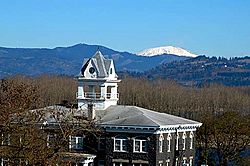
The Columbia County Courthouse with Mount St. Helens in the background
|
||
|
||

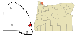
Location in Oregon
|
||
| Country | United States | |
| State | Oregon | |
| County | Columbia | |
| Incorporated | 1889 | |
| Government | ||
| • Type | Mayor-council government | |
| Area | ||
| • Total | 5.95 sq mi (15.41 km2) | |
| • Land | 4.83 sq mi (12.51 km2) | |
| • Water | 1.12 sq mi (2.90 km2) | |
| Elevation | 89 ft (27 m) | |
| Population
(2020)
|
||
| • Total | 13,817 | |
| • Density | 2,860.07/sq mi (1,104.33/km2) | |
| Time zone | UTC−8 (Pacific) | |
| • Summer (DST) | UTC−7 (Pacific) | |
| Zip Code |
97051
|
|
| FIPS code | 41-64600 | |
| GNIS feature ID | 2411759 | |
| Website | https://www.sthelensoregon.gov | |
St. Helens is the main city of Columbia County, Oregon. It was started in 1845 by Captain Henry Montgomery Knighton. He was from New England and first named the town "Plymouth". The name changed to St. Helens in 1850. It was named after Mount St. Helens, a volcano about 39 miles (63 km) away in Washington.
The city is about 28 miles (45 km) northwest of Portland. In 2020, about 13,817 people lived there.
Contents
History of St. Helens
Early Explorers and Settlement
The famous Lewis and Clark Expedition traveled through this area. They camped near what is now St. Helens on November 5, 1805. This was during their journey to the Pacific Ocean. While there, they met Native Americans. Clark also noted the "low rockey clifts" along the river.
St. Helens began as a busy river port in the 1840s. It was located on the Columbia River. A man from Scotland named Peter Crawford planned and mapped out the first town.
Growth and Mergers
In 1853, the Pacific Mail Steamship Company tried to make St. Helens their only stop on the Columbia River. But merchants in Portland did not like this idea. A steamship from San Francisco, the Peytona, helped to solve this problem. St. Helens officially became a city in 1889.
Later, in 1914, St. Helens joined with a nearby town called Houlton. Today, Houlton is part of the West St. Helens neighborhood.
Geography and Climate
Where is St. Helens?
U.S. Route 30 runs through the city. St. Helens is on the west side of the Columbia River. It is just north of where the Multnomah Channel flows into the Columbia River. A creek called Milton Creek also flows through the town. It empties into the Multnomah Channel through Scappoose Bay.
The United States Census Bureau says the city covers about 5.51 square miles (14.27 square kilometers). About 4.53 square miles (11.73 square kilometers) is land. The other 0.98 square miles (2.54 square kilometers) is water.
St. Helens Weather
St. Helens has a warm-summer Mediterranean climate. This means it has warm, dry summers and mild, wet winters.
| Climate data for St. Helens, Oregon | |||||||||||||
|---|---|---|---|---|---|---|---|---|---|---|---|---|---|
| Month | Jan | Feb | Mar | Apr | May | Jun | Jul | Aug | Sep | Oct | Nov | Dec | Year |
| Record high °F (°C) | 63 (17) |
71 (22) |
82 (28) |
90 (32) |
102 (39) |
117 (47) |
106 (41) |
107 (42) |
106 (41) |
94 (34) |
72 (22) |
62 (17) |
117 (47) |
| Mean daily maximum °F (°C) | 46.5 (8.1) |
50.5 (10.3) |
55.4 (13.0) |
60.7 (15.9) |
67.8 (19.9) |
72.6 (22.6) |
80.4 (26.9) |
81.6 (27.6) |
75.7 (24.3) |
63.4 (17.4) |
52.4 (11.3) |
45.7 (7.6) |
62.7 (17.1) |
| Daily mean °F (°C) | 40.6 (4.8) |
42.6 (5.9) |
46.5 (8.1) |
50.7 (10.4) |
57.1 (13.9) |
61.5 (16.4) |
67.6 (19.8) |
68.2 (20.1) |
62.9 (17.2) |
53.5 (11.9) |
45.4 (7.4) |
40.2 (4.6) |
53.0 (11.7) |
| Mean daily minimum °F (°C) | 34.7 (1.5) |
34.7 (1.5) |
37.5 (3.1) |
40.6 (4.8) |
46.3 (7.9) |
50.4 (10.2) |
54.8 (12.7) |
54.7 (12.6) |
50.1 (10.1) |
43.5 (6.4) |
38.3 (3.5) |
34.6 (1.4) |
43.3 (6.3) |
| Record low °F (°C) | 9 (−13) |
4 (−16) |
18 (−8) |
20 (−7) |
21 (−6) |
34 (1) |
38 (3) |
30 (−1) |
34 (1) |
20 (−7) |
10 (−12) |
1 (−17) |
1 (−17) |
| Average precipitation inches (mm) | 6.33 (161) |
4.76 (121) |
4.76 (121) |
3.81 (97) |
2.77 (70) |
1.85 (47) |
0.39 (9.9) |
0.78 (20) |
1.84 (47) |
3.94 (100) |
6.68 (170) |
7.56 (192) |
45.45 (1,154) |
| Average snowfall inches (cm) | 1.3 (3.3) |
0.4 (1.0) |
0 (0) |
0 (0) |
0 (0) |
0 (0) |
0 (0) |
0 (0) |
0 (0) |
0 (0) |
0.4 (1.0) |
0.8 (2.0) |
3 (7.6) |
| Average precipitation days | 18 | 15 | 17 | 15 | 12 | 9 | 4 | 5 | 7 | 12 | 18 | 18 | 150 |
| Source 1: Temperature and precip averages | |||||||||||||
| Source 2: Record highs, lows, and snowfall averages, June 2021 record high | |||||||||||||
City Neighborhoods
Columbia Heights used to be a separate place. Now, it is part of the city of St. Helens.
People of St. Helens
Population Growth
In 2017, about 13,240 people were estimated to live in St. Helens. The city's population has grown a lot over the years.
| Historical population | |||
|---|---|---|---|
| Census | Pop. | %± | |
| 1880 | 209 | — | |
| 1890 | 220 | 5.3% | |
| 1900 | 258 | 17.3% | |
| 1910 | 743 | 188.0% | |
| 1920 | 2,220 | 198.8% | |
| 1930 | 3,994 | 79.9% | |
| 1940 | 4,304 | 7.8% | |
| 1950 | 4,711 | 9.5% | |
| 1960 | 5,022 | 6.6% | |
| 1970 | 6,212 | 23.7% | |
| 1980 | 7,064 | 13.7% | |
| 1990 | 7,535 | 6.7% | |
| 2000 | 10,019 | 33.0% | |
| 2010 | 12,883 | 28.6% | |
| 2020 | 13,817 | 7.2% | |
| Sources: | |||
Who Lives in St. Helens? (2010 Census)
In 2010, there were 12,883 people living in St. Helens. They lived in 4,847 homes. About 3,243 of these were families. The city had about 2,844 people per square mile (1,104 per square kilometer).
Most people (90.3%) were White. Other groups included Native American (1.6%) and Asian (1.3%). About 6.1% of the population was Hispanic or Latino.
About 38.6% of homes had children under 18. Many homes (46.5%) were married couples. The average home had 2.59 people. The average family had 3.11 people.
The average age in the city was 34 years old. About 27.6% of people were under 18. About 10.2% were 65 or older. The city had slightly more females (50.2%) than males (49.8%).
Fun Things to Do
St. Helens for Visitors
In October, St. Helens celebrates Halloween with many fun events. The city decorates its Riverfront District. These events are great for families.
The Riverfront District was used as a filming location for the 1998 Disney Channel movie Halloweentown. Parts of the movie Twilight, based on Stephenie Meyer's book, were also filmed here.
Education in St. Helens
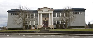
Public schools in St. Helens are managed by the St. Helens School District.
Local Media
The Chronicle was a weekly newspaper for St. Helens. It was published since 1881 but stopped in 2024.
KOHI (AM) is the local radio station for St. Helens.
Famous People from St. Helens
- Robert Cornthwaite, an actor
- Rob Mallicoat, a baseball player
- David Mayo, an American football player
- Frank A. Moore, a Chief Justice of the Oregon Supreme Court
- Katee Sackhoff, an actress
- Chris Wakeland, a baseball player
Sister City
St. Helens has one sister city:
See also
 In Spanish: St. Helens (Oregón) para niños
 | Madam C. J. Walker |
 | Janet Emerson Bashen |
 | Annie Turnbo Malone |
 | Maggie L. Walker |


