
Columbia County, Oregon facts for kids
Quick facts for kids
Columbia County
|
|
|---|---|

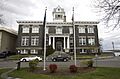
Columbia County Courthouse in St. Helens
|
|

Location within the U.S. state of Oregon
|
|
 Oregon's location within the U.S. |
|
| Country | |
| State | |
| Founded | January 16, 1854 |
| Named for | Columbia River |
| Seat | St. Helens |
| Largest city | St. Helens |
| Area | |
| • Total | 688 sq mi (1,780 km2) |
| • Land | 657 sq mi (1,700 km2) |
| • Water | 31 sq mi (80 km2) 4.5%% |
| Population
(2020)
|
|
| • Total | 52,589 |
| • Estimate
(2023)
|
53,880 |
| • Density | 75/sq mi (29/km2) |
| Time zone | UTC−8 (Pacific) |
| • Summer (DST) | UTC−7 (PDT) |
| Congressional district | 1st |
Columbia County is one of the 36 counties in the U.S. state of Oregon. It is located in the northwest part of the state. As of the 2020 census, about 52,589 people lived there. The main city and county seat is St. Helens. The county is named after the famous Columbia River.
Contents
History of Columbia County
Long ago, the Chinook and Clatskanie Native American tribes lived in this area. They were here for hundreds of years before European explorers arrived. In 1792, a sea captain named Robert Gray sailed his ship, the Columbia Rediviva, into the Columbia River.
Later, in 1805 and 1806, the famous Lewis and Clark Expedition traveled along the Columbia River. They camped on the riverbanks in the area that would become Columbia County.
Columbia County was officially created in 1854. It was formed from the northern part of Washington County. At first, the county seat was a town called Milton. But in 1857, the county seat was moved to St. Helens, where it remains today.
The county has faced several big floods over the years. One of the most recent was in December 2007. Heavy rains caused the Nehalem River to overflow. This flooded the city of Vernonia and nearby rural areas. Because of this, the President declared it a disaster area.
Geography of Columbia County
Columbia County covers about 688 square miles. Most of this (657 square miles) is land, and 31 square miles (about 4.5%) is water. It is one of Oregon's smaller counties in terms of land area.

Neighboring Counties
Columbia County shares borders with several other counties:
- Wahkiakum County, Washington (to the northwest)
- Cowlitz County, Washington (to the northeast)
- Clark County, Washington (to the east)
- Multnomah County (to the southeast)
- Washington County (to the south)
- Clatsop County (to the west)
Protected Natural Areas
Part of the Julia Butler Hansen National Wildlife Refuge is located in Columbia County. This refuge helps protect wildlife and their habitats.
People of Columbia County
Over the years, the number of people living in Columbia County has grown a lot. In 1860, there were only 532 people. By 2020, the population had reached over 52,000!
The people living in Columbia County come from many different backgrounds. Most residents are White. There are also people who are American Indian, Asian, Black, Pacific Islander, and from other racial groups. Many people in the county also have Hispanic or Latino roots.
Communities in Columbia County
Columbia County has several towns and cities, as well as smaller communities.

Cities
- Clatskanie
- Columbia City
- Prescott
- Rainier
- St. Helens (This is the county seat, where the main government offices are)
- Scappoose
- Vernonia
Census-Designated Places (CDPs)
These are areas that are like towns but are not officially incorporated as cities.
Unincorporated Communities
These are smaller communities that are not part of any city or CDP.
Media and News
Columbia County has had local newspapers for a long time. The Clatskanie Chief started in 1891, and the Rainier Review began in 1895. The St. Helens Chronicle also has a long history.
Today, The Columbia County Chronicle & Chief used to be a main newspaper for the county, but it stopped publishing in 2024. The South County Spotlight, which started in 1961, still serves the area.
There is also one AM radio station, KOHI AM 1600. It has been broadcasting since 1959 and is owned locally.
Economy
The main ways people make a living in Columbia County are through wood products and paper manufacturing. Other important jobs are in trade, construction, and growing plants (horticulture).
In the past, the county had huge forests with very old trees. These trees were all cut down by the 1950s. Now, new, younger trees provide the wood for local lumber and paper mills.
Many people who live in Columbia County travel outside the county for work. Most of them go to the nearby Portland, Oregon area for their jobs.
Transportation
Public Transit

Columbia County Rider (CC Rider) is the public bus service in Columbia County. It has several bus lines that connect different parts of the county, like downtown St. Helens and Scappoose. It also helps people travel to other places like Portland.
The CC Rider service is mostly paid for by grants from the state and federal governments.
Major Highways
Several important highways pass through Columbia County, making it easy to travel by car.
 US 26
US 26 US 30
US 30
US 30 Bus. OR 47
OR 47 OR 202
Images for kids
-
Columbia County Courthouse in St. Helens
See also
 In Spanish: Condado de Columbia (Oregón) para niños
