
Multnomah County, Oregon facts for kids
Quick facts for kids
Multnomah County
|
|||
|---|---|---|---|
|
|||

Location within the U.S. state of Oregon
|
|||
 Oregon's location within the U.S. |
|||
| Country | |||
| State | |||
| Founded | December 22, 1854 | ||
| Named for | Multnomah people | ||
| Seat | Portland | ||
| Largest city | Portland | ||
| Area | |||
| • Total | 466 sq mi (1,210 km2) | ||
| • Land | 431 sq mi (1,120 km2) | ||
| • Water | 34 sq mi (90 km2) 7.4%% | ||
| Population
(2020)
|
|||
| • Total | 815,428 | ||
| • Estimate
(2023)
|
789,698 |
||
| • Density | 1,749.8/sq mi (675.6/km2) | ||
| Time zone | UTC−8 (Pacific) | ||
| • Summer (DST) | UTC−7 (PDT) | ||
| Congressional districts | 1st, 3rd, 5th | ||


Multnomah County is one of the 36 counties in the U.S. state of Oregon. In 2020, about 815,428 people lived here. It is part of the larger Portland metropolitan area. Multnomah County is the smallest county in Oregon by size, but it has the most people. Its main city, Portland, is also the largest city in Oregon.

Contents
History of Multnomah County
The land around the lower Willamette River has been home to people for thousands of years. The Multnomah people, part of the Chinookan peoples, lived here long before Europeans arrived. We know this from places like the Cathlapotle village nearby.
Multnomah County was officially created on December 22, 1854. It was formed from parts of two other Oregon counties: Washington County and Clackamas County. Business owners in Portland asked for this new county. They found it hard to travel to the county seat in Hillsboro. They also wanted to keep more of Portland's tax revenue within their city. The county's first leaders met on January 17, 1855.
The county's name comes from a Chinookan word, multnomah. This word means "lower river" or "toward the great water." The explorer William Clark wrote about a river he called "Multnomah" in his journal. He may have been referring to the Willamette River.
In 1924, the county's three leaders were removed from office by voters. This happened because of problems with how they awarded contracts for building the Burnside Bridge and Ross Island Bridge. Their removal also helped reduce the influence of certain groups in the city.
Vanport was a town built north of Portland in 1943. It housed workers for shipyards during World War II. Sadly, a big flood destroyed the town five years later.
In 1968, Oregon voters approved a change to the state constitution. This change allowed large cities and counties to combine their governments. Multnomah County was the only county in Oregon big enough for this. Since then, people have sometimes suggested that Multnomah County and Portland should merge.
Multnomah County Since 2000
In the 2000 presidential election, Multnomah County played a big role in deciding who won Oregon's votes. The county's votes helped Al Gore win Oregon. The county has continued to vote for Democratic candidates in later elections.
In 2001, the Multnomah County Library decided to take legal action. They wanted to stop a law called the Children's Internet Protection Act. This law would have required libraries to filter internet access. The US Supreme Court later said the law was constitutional. However, the library chose to give up federal funding to keep offering unfiltered internet access to everyone.
In 2003, voters in Multnomah County approved a special local income tax. This was during a time when the local economy was struggling. The tax helped prevent cuts to schools, police, and social services. Multnomah County was one of the few places in Oregon to approve such a tax increase.
Geography of Multnomah County
Multnomah County covers about 466 square miles. About 34 square miles of this area is water, mostly from rivers. It is the smallest county in Oregon by land area. The county is located along the south side of the Columbia River.
The county has several old, inactive volcanoes from the Boring Lava Field. The eastern part of the county's northern border includes the Oregon side of the Columbia River Gorge.
Major Highways
Neighboring Counties
- Columbia County – northwest
- Clark County, Washington – north
- Skamania County, Washington – northeast
- Hood River County – east
- Clackamas County – south
- Washington County – west
Protected Natural Areas
- Columbia River Gorge National Scenic Area (part)
- Mount Hood National Forest (part)
People of Multnomah County (Demographics)
| Historical population | |||
|---|---|---|---|
| Census | Pop. | %± | |
| 1860 | 4,150 | — | |
| 1870 | 11,510 | 177.3% | |
| 1880 | 25,203 | 119.0% | |
| 1890 | 74,884 | 197.1% | |
| 1900 | 103,167 | 37.8% | |
| 1910 | 226,261 | 119.3% | |
| 1920 | 275,898 | 21.9% | |
| 1930 | 338,241 | 22.6% | |
| 1940 | 355,099 | 5.0% | |
| 1950 | 471,537 | 32.8% | |
| 1960 | 522,813 | 10.9% | |
| 1970 | 556,667 | 6.5% | |
| 1980 | 562,640 | 1.1% | |
| 1990 | 583,887 | 3.8% | |
| 2000 | 660,486 | 13.1% | |
| 2010 | 735,334 | 11.3% | |
| 2020 | 815,428 | 10.9% | |
| 2023 (est.) | 789,698 | 7.4% | |
| U.S. Decennial Census 1790–1960 1900–1990 1990–2000 2010–2020 |
|||
Racial and Ethnic Makeup Since 1960
| Racial composition | 2020 | 2010 | 2000 | 1990 | 1980 | 1970 | 1960 |
|---|---|---|---|---|---|---|---|
| White (non-Hispanic) | 65.7% | 72.1% | 76.5% | 85.3% | 88.4% | – | – |
| Hispanic or Latino | 12.7% | 10.9% | 7.5% | 3.1% | 2.0% | 1.5% | – |
| Asian (non-Hispanic) | 7.5% | 6.5% | 5.7% | 4.6% | – | – | 1.2% |
| Black or African American (non-Hispanic) | 5.4% | 5.4% | 5.6% | 6.0% | 5.3% | 3.9% | 3.0% |
| Native American (non-Hispanic) | 0.7% | 0.8% | 1.0% | 1.1% | – | – | 0.2% |
| Pacific Islander (non-Hispanic) | 0.7% | 0.5% | 0.3% | – | – | – | – |
| Mixed race (non-Hispanic) | 6.8% | 3.6% | 4.0% | – | – | – | – |
2020 Census Information
| Race / Ethnicity | Pop 2000 | Pop 2010 | Pop 2020 | % 2000 | % 2010 | % 2020 |
|---|---|---|---|---|---|---|
| White alone (NH) | 505,492 | 530,303 | 535,623 | 76.5% | 72.1% | 65.7% |
| Black or African American alone (NH) | 36,592 | 39,919 | 43,793 | 5.6% | 5.4% | 5.4% |
| Native American or Alaska Native alone (NH) | 5,754 | 5,527 | 5,455 | 1.0% | 0.8% | 0.7% |
| Asian alone (NH) | 37,344 | 47,508 | 61,280 | 5.7% | 6.5% | 7.5% |
| Pacific Islander alone (NH) | 2,206 | 3,870 | 5,251 | 0.3% | 0.5% | 0.7% |
| Other race alone (NH) | 1,216 | 1,520 | 4,885 | —% | —% | —% |
| Mixed race or Multiracial (NH) | 22,275 | 26,549 | 55,388 | 4.0% | 3.6% | 6.8% |
| Hispanic or Latino (any race) | 49,607 | 80,138 | 103,753 | 7.5% | 10.9% | 12.7% |
| Total | 660,486 | 735,334 | 815,428 | 100.0% | 100.0% | 100.0% |
In 2020, Multnomah County had 815,428 people living there. There were 341,507 households and 180,512 families. The county's population density was about 1,891 people per square mile.
The main racial groups were 65.7% White, 5.4% Black or African American, 0.7% Native American, 7.5% Asian, 0.7% Pacific Islander, and 6.8% from two or more races. About 12.7% of the population was Hispanic or Latino.
The average household income in the county was $83,668. The income per person was $49,713. About 12.1% of the people lived below the poverty line.
2010 Census Information
In 2010, there were 735,334 people living in Multnomah County. There were 304,540 households. The population density was about 1,705 people per square mile.
The racial makeup was 76.5% White, 6.5% Asian, 5.6% Black or African American, 1.1% American Indian, 0.5% Pacific Islander, 5.1% from other races, and 4.6% from two or more races. People of Hispanic or Latino origin made up 10.9% of the population.
The average age in the county was 35.7 years. The average household income was $49,618. About 16.0% of the population lived below the poverty line.
Economy of Multnomah County
The main industries in Multnomah County are making goods (manufacturing), moving goods (transportation), and buying and selling goods (wholesale and retail trade). Tourism is also very important. Oregon does not have a sales tax, which means many shoppers from nearby Washington state come to Multnomah County.
The Port of Portland was started in 1891. It is a very busy port on the West Coast. It ranks third for total water trade on the West Coast. Portland is one of the five largest ports for importing cars in the nation. It is also the West Coast's top exporter of grain and lumber. The Port of Portland also manages Portland International Airport (PDX) and the Portland-Troutdale Airport.
Fun Places to Visit (Tourism)
Multnomah County has many popular attractions and places to visit, especially in Portland. These include:
- Oregon Museum of Science and Industry (OMSI)
- Portland Art Museum
- Memorial Coliseum
- Oregon Convention Center
- Moda Center
- Providence Park
- Washington Park
- Oregon Zoo
- International Rose Test Garden
- Lan Su Chinese Garden
- Portland Japanese Garden
- Hoyt Arboretum
- Pittock Mansion
Outside of Portland, you can also visit the Historic Columbia River Highway, Multnomah Falls, and Oxbow Regional Park.
Communities in Multnomah County
Cities
- Fairview
- Gresham
- Lake Oswego (small part)
- Maywood Park
- Milwaukie (small part)
- Portland (county seat)
- Troutdale
- Wood Village
Census-Designated Places (CDPs)
These are areas that are like towns but are not officially incorporated as cities.
- Cedar Mill (part)
- Dunthorpe
- Orient
- West Haven-Sylvan (part)
Unincorporated Communities
These are smaller communities that are not part of any city.
Education in Multnomah County
Many different school districts serve the students in Multnomah County. These include:
- Beaverton School District 48J
- Centennial School District 28J
- Corbett School District 39
- David Douglas School District 40
- Gresham-Barlow School District 1J
- Hillsboro School District 1J
- Lake Oswego School District 7J
- Parkrose School District 3
- Portland School District 1J
- Rainier School District 13
- Reynolds School District 7
- Riverdale School District 51J
- Scappoose School District 1J
For older students, Portland Community College serves the western parts of the county. Mt. Hood Community College serves the eastern parts.
Images for kids
-
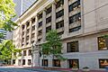
Old Multnomah County Courthouse
See also
 In Spanish: Condado de Multnomah para niños
