Skamania County, Washington facts for kids
Quick facts for kids
Skamania County
|
|
|---|---|

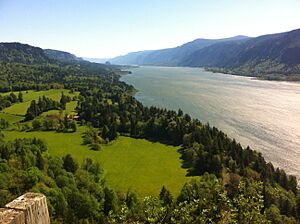
Skamania County panorama
|
|

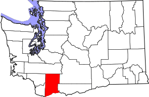
Location within the U.S. state of Washington
|
|
 Washington's location within the U.S. |
|
| Country | |
| State | |
| Founded | March 9, 1854 |
| Seat | Stevenson |
| Largest city | Carson |
| Area | |
| • Total | 1,683 sq mi (4,360 km2) |
| • Land | 1,656 sq mi (4,290 km2) |
| • Water | 28 sq mi (70 km2) 1.7% |
| Population
(2020)
|
|
| • Total | 12,036 |
| • Estimate
(2023)
|
12,640 |
| • Density | 7.15/sq mi (2.76/km2) |
| Time zone | UTC−8 (Pacific) |
| • Summer (DST) | UTC−7 (PDT) |
| Congressional district | 3rd |
Skamania County is a county in the state of Washington. In 2020, about 12,036 people lived here. The main town and county seat is Stevenson. However, the area called Carson River Valley has more people. Skamania County is part of the larger Portland-Vancouver-Hillsboro city region.
History
What's in a Name?
Skamania County was created in 1854. Its name comes from an old Chinook word, sk'mániak. This word means 'swift waters'. It likely refers to the fast-moving rivers in the area.
How the County Began
In the early 1800s, both Americans and British people started settling in the area that would become Washington state. The British were mostly interested in fur trading. American settlers wanted land for farming and raising animals. For a while, the area was shared by both countries. This was called a condominium.
This shared control led to many arguments. In 1846, the Oregon Treaty gave the land south of 49 degrees north to American control. On March 9, 1854, Skamania County was officially formed. It was split off from an older county called Clarke County.
At first, Skamania County was very large. It stretched all the way east to the Rocky Mountains. But over time, parts of it were used to create new counties. Walla Walla County was formed from its eastern parts in April 1854. Later, Klickitat County was created in 1861.
In 1865, the county was briefly dissolved because of a tax problem. But the U.S. Congress stepped in, and it was brought back in 1867. Since then, Skamania County has kept its shape. Fort Cascades, a fort built to protect the Columbia River, was the first county seat. But since 1893, Stevenson has been the county seat.
Recent History
Skamania County is famous for something called the "Bigfoot Ordinance." This rule was passed on April 1, 1969. It makes it illegal to kill a "nocturnal primate mammal" known as a "Sasquatch," "Yeti," or "Bigfoot." The punishment could be a $10,000 fine and five years in prison.
Even though it was passed on April Fool's Day, this rule is real! It was updated in 1984 and is still in effect. The main reason for the rule was to protect people. Many scientists and hunters were coming to the area after Bigfoot sightings. The county wanted to prevent problems from too many armed people.
Mount St. Helens, a famous volcano, is located in Skamania County. It erupted in 1980. This was a very big event that changed the landscape.
Geography
Skamania County covers about 1,684 square miles. Most of this (1,656 square miles) is land. About 28 square miles, or 1.7%, is water. A huge part of the county, 90%, is covered in forests. Also, 80% of the county is part of the Gifford Pinchot National Forest.
The highest point in the county is Mount Adams, which is 8,920 feet tall. Before it erupted, Mount St. Helens was the highest point at 9,677 feet.
Natural Features
Main Roads
Neighboring Counties
- Lewis County - north
- Yakima County - northeast
- Klickitat County - east
- Hood River County, Oregon - south
- Multnomah County, Oregon - southwest
- Clark County - west
- Cowlitz County - west
Population Information
| Historical population | |||
|---|---|---|---|
| Census | Pop. | %± | |
| 1860 | 173 | — | |
| 1870 | 133 | −23.1% | |
| 1880 | 809 | 508.3% | |
| 1890 | 774 | −4.3% | |
| 1900 | 1,688 | 118.1% | |
| 1910 | 2,887 | 71.0% | |
| 1920 | 2,357 | −18.4% | |
| 1930 | 2,891 | 22.7% | |
| 1940 | 4,633 | 60.3% | |
| 1950 | 4,788 | 3.3% | |
| 1960 | 5,207 | 8.8% | |
| 1970 | 5,845 | 12.3% | |
| 1980 | 7,919 | 35.5% | |
| 1990 | 8,289 | 4.7% | |
| 2000 | 9,872 | 19.1% | |
| 2010 | 11,066 | 12.1% | |
| 2020 | 12,036 | 8.8% | |
| 2023 (est.) | 12,640 | 14.2% | |
| U.S. Decennial Census 1790–1960 1900–1990 1990–2000 2010–2020 |
|||
2020 Census Details
In 2020, there were 12,036 people living in Skamania County. There were 4,748 households, which are groups of people living together. The population density was about 7.3 people per square mile.
Most people (85.6%) were White. About 1.6% were Native American, and 1.0% were Asian. People of Hispanic or Latino background made up 6.4% of the population. About 16.7% of residents were under 18 years old. Also, 25.8% were 65 years or older.
2010 Census Details
In 2010, the county had 11,066 people. There were 4,522 households. The average household had 2.44 people. The average age of people in the county was 44 years old.
Fun Things to Do
Skamania County has many trails for hiking. You can explore the Columbia River Gorge and the Gifford Pinchot National Forest. This forest includes the Mount St. Helens National Volcanic Monument. The famous Pacific Crest Trail also goes through the county.
Fishing is popular here. You can catch fish like rainbow trout, steelhead, and bass. The Columbia Gorge Museum in Stevenson teaches about the area's history. You can also visit places where the Lewis and Clark Expedition camped long ago.
Historical markers show important spots like Fort Cascades and Fort Raines. These forts were built in the 1850s. They protected a road around the Cascades Rapids. If you like water sports, kiteboarding and windsurfing are popular in the Columbia River Gorge during certain seasons.
Parks and Other Protected Areas
County Parks
- Prindle Park has picnic areas and a playground.
- Big Cedars Campground offers simple campsites.
- Home Valley Campground is another county camping spot.
State Parks
- Beacon Rock State Park is great for hiking, camping, rock climbing, and picnicking.
Forest Service Sites
- Sams Walker Day Use Site has a trail and river access. You can also watch for wildlife here.
- St. Cloud Day Use Site offers an easy trail, a picnic area, and river access. It's also good for spotting wildlife.
National Protected Areas
- Franz Lake National Wildlife Refuge
- Gifford Pinchot National Forest (part of it)
- Mount St. Helens National Monument (part of it)
- Pierce National Wildlife Refuge
- Wind River Arboretum
- Wind River Experimental Forest
Communities
Cities
- North Bonneville
- Stevenson (the county seat)
Census-Designated Places
- Carson
- Carson River Valley (used to be one)
Small Towns and Areas (Unincorporated)
See also
 In Spanish: Condado de Skamania para niños
 | Stephanie Wilson |
 | Charles Bolden |
 | Ronald McNair |
 | Frederick D. Gregory |

