North Bonneville, Washington facts for kids
Quick facts for kids
North Bonneville
|
|
|---|---|

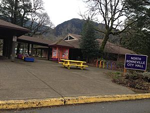
City Hall in North Bonneville, February 2016
|
|

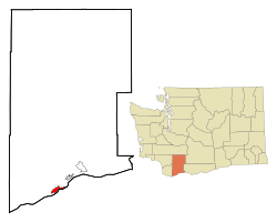
Location of North Bonneville, Washington
|
|
| Country | United States |
| State | Washington |
| County | Skamania |
| Area | |
| • Total | 2.78 sq mi (7.19 km2) |
| • Land | 2.52 sq mi (6.54 km2) |
| • Water | 0.25 sq mi (0.65 km2) |
| Elevation | 66 ft (20 m) |
| Population
(2020)
|
|
| • Total | 1,397 |
| • Density | 502.5/sq mi (194.30/km2) |
| Time zone | UTC-8 (Pacific (PST)) |
| • Summer (DST) | UTC-7 (PDT) |
| ZIP code |
98639
|
| Area code | 509 |
| FIPS code | 53-49555 |
| GNIS feature ID | 1531485 |
| Website | City of North Bonneville |
North Bonneville is a small city in Washington, United States. It is located in Skamania County, right along the Columbia River. This area is part of the beautiful Columbia River Gorge National Scenic Area. In 2020, about 1,397 people lived there.
Contents
History of North Bonneville
North Bonneville started as a town for workers. These workers were building a huge project called the Bonneville Lock, Dam, and powerhouse. This big construction began in late 1933. The city of North Bonneville officially became a city on June 25, 1935.
Moving the City
Later, in 1971, the government decided to build a second powerhouse. This new powerhouse would be built exactly where North Bonneville was located. The people of the town did not want to leave their community. They worked very hard to find a way to move the entire town.
With help from the state and the U.S. Army Corps of Engineers, they planned a new town. Experts designed and built a new place for everyone to live. Contractors prepared the new town site for about 600 people. The old town was then taken apart to make way for the new powerhouse.
Building the New Town
In 1974, a special law called Public Law 93-251 was passed. This law made sure the U.S. Army Corps of Engineers had to help North Bonneville move. The project cost about $35 million.
The new town was built on higher ground to protect it from floods. It included new streets, water pipes, electricity, and a sewage system. They also built parks, a main business area, and all the public buildings. Even highways and railways had to be moved! People and businesses lived in temporary homes until their new permanent ones were ready. The new North Bonneville was built to hold 1,500 residents. Everyone celebrated the successful move on July 29, 1978.
Geography and Climate
North Bonneville is located at 45°38′39″N 121°58′5″W / 45.64417°N 121.96806°W. It covers a total area of about 2.62 square miles (6.79 square kilometers). Most of this area is land, and a small part is water.
Local Climate
The weather in North Bonneville is usually warm and dry in the summer. The average monthly temperatures do not get very hot. This type of weather is called a "warm-summer Mediterranean climate." On climate maps, you might see it labeled as "Csb."
Population Information
| Historical population | |||
|---|---|---|---|
| Census | Pop. | %± | |
| 1940 | 643 | — | |
| 1950 | 564 | −12.3% | |
| 1960 | 494 | −12.4% | |
| 1970 | 459 | −7.1% | |
| 1980 | 394 | −14.2% | |
| 1990 | 411 | 4.3% | |
| 2000 | 593 | 44.3% | |
| 2010 | 956 | 61.2% | |
| 2020 | 1,397 | 46.1% | |
| U.S. Decennial Census 2020 Census |
|||
2010 Census Details
In 2010, there were 956 people living in North Bonneville. There were 420 households, which are groups of people living together. The city had about 397 people per square mile (153 people per square kilometer).
Most of the people living there were White (94.9%). A small number were Asian, Native American, or African American. About 4.4% of the population was Hispanic or Latino.
About 28.6% of households had children under 18. Many households (45.7%) were married couples. The average age of people in the city was 42.8 years old. About 24.1% of residents were under 18. The number of males and females was almost equal.
Parks and Outdoor Fun
North Bonneville is in the amazing Columbia River Gorge National Scenic Area. This means there are many cool places nearby to explore!
You can visit Beacon Rock State Park or the Pierce National Wildlife Refuge. If you like hiking, the famous Pacific Crest Trail is close by. You can also hike up Greenleaf Peak and Table Mountain.
From the city, you can see the huge Bonneville Dam and its spillway. Another important structure nearby is the Bridge of the Gods, which crosses the Columbia River.
See also
 In Spanish: North Bonneville (Washington) para niños
 | Janet Taylor Pickett |
 | Synthia Saint James |
 | Howardena Pindell |
 | Faith Ringgold |

