Table Mountain (Skamania County, Washington) facts for kids
Quick facts for kids Table Mountain |
|
|---|---|

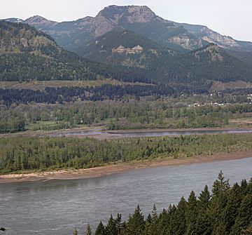
South face of Table Mountain and Columbia River from John B. Yeon State Scenic Corridor
|
|
| Highest point | |
| Elevation | 3,417 ft (1,042 m) NGVD 29 |
| Prominence | 377 ft (115 m) |
| Geography | |
| Location | Skamania County, Washington, U.S. |
| Parent range | Cascade Range |
| Topo map | USGS Bonneville Dam |
| Geology | |
| Mountain type | Basalt |
Table Mountain is a tall mountain located in Washington state. It rises on the north side of the Columbia River, about 4 miles north of the Bonneville Dam. This mountain is one of the most famous and impressive sights in the Columbia River Gorge.
The southeast side of Table Mountain drops down 2,400 feet very quickly. At its top, there is an almost straight-up 800-foot cliff. Nearby, you can see other mountains like Greenleaf Peak and Hamilton Mountain. Even though Hamilton Mountain is lower, it is also very steep and closer to the Columbia River. Together, these mountains create a stunning view on the Washington side of the Gorge.
A Giant Landslide
Between the years 1425 and 1450 AD, a huge part of the south side of Table Mountain broke off. This event is known as the Bonneville Slide.
How the Slide Changed the River
When the landslide happened, it blocked the Columbia River. For a while, the river was completely dammed up. This created a natural land bridge across the river.
The Legend of the Bridge of the Gods
After the slide, Native American people living in the area could walk across the river on this new land bridge. This amazing event led to a famous story called the Bridge of the Gods. The river eventually carved a new path around the south side of the slide.
 | Selma Burke |
 | Pauline Powell Burns |
 | Frederick J. Brown |
 | Robert Blackburn |

