
Mount St. Helens National Volcanic Monument facts for kids
Quick facts for kids Mount St. Helens National Volcanic Monument |
|
|---|---|

Mount St. Helens from the Johnston Ridge Observatory (July 2018)
|
|

Mount St. Helens National Volcanic Monument
Location in Washington (state)

Mount St. Helens National Volcanic Monument
Location in the United States
|
|
| Location | Skamania / Cowlitz / Lewis counties, Washington, United States |
| Nearest city | Castle Rock, Washington |
| Area | 110,000 acres (450 km2) |
| Created | August 26, 1982 |
| Governing body | U.S. Forest Service |
| Website | Mount St. Helens National Volcanic Monument |
The Mount St. Helens National Volcanic Monument is a special protected area in Washington state, USA. It was created after the huge 1980 eruption of Mount St. Helens. The monument covers about 110,000 acres (445 square kilometers) and was set up for research, fun activities, and learning.
The U.S. Congress established this monument on August 27, 1982. Inside the monument, nature is allowed to recover on its own after the volcanic disturbance. The U.S. Forest Service manages this area, and it's part of the Gifford Pinchot National Forest.
When the monument was dedicated in 1983, officials said they were proud to save this unique natural event for future generations. Since then, many trails, viewpoints, and visitor centers have been built. These help people explore and learn about the volcano. The state of Washington even celebrates May as "Volcano Awareness Month." During this time, events are held to remember the eruption and teach people about volcano safety.
Since 1986, people have been allowed to climb to the top of the volcano, but you need a special permit to do so.
Contents
Mount St. Helens Visitor Center at Silver Lake
The Mount St. Helens Visitor Center at Silver Lake is about 30 miles (48 km) west of the volcano. It opened in 1987. This center is now run by Washington State Parks.
Inside, you can find exhibits about the local culture and history. There are also displays about the volcano's geology and the 1980 eruption. You can learn how plants and animals have returned to the area. The center has a theater, a gift shop, and outdoor trails.
In 2024, the center got a big upgrade. New artworks and exhibits were added, showing the history of the Cowlitz Indian Tribe and their connection to the mountain. There are also new science displays about earthquakes and volcanoes. The renovated center reopened in May 2025.
Johnston Ridge Observatory

The Johnston Ridge Observatory is about 52 miles (84 km) east of Castle Rock, Washington. It sits close to the mountain, offering amazing views. Usually, it's open from mid-May through October.
The observatory teaches visitors about the volcano's history and what it was like during the 1980 eruption. You can also learn about how scientists watch for volcanic activity. There are movies and ranger-led programs every hour. A paved trail outside gives you views of the lava dome, the crater, and the landslide area.
The observatory is named after volcanologist David A. Johnston. He was at a camp nearby on the morning of the 1980 eruption. The observatory itself opened in 1997.
Unfortunately, access to the observatory has been closed since May 2023. A large landslide, called the 2023 South Coldwater Slide, destroyed a bridge on the main road. Because of the high costs and difficult conditions for repairs, the road and observatory are expected to remain closed until 2026 or 2027.
Science and Learning Center at Coldwater

The Science and Learning Center at Coldwater (SLC) is another important visitor spot. It first opened in 1993 as the Coldwater Ridge Visitor Center. After closing for a while, it reopened in May 2013.
Today, the SLC works with the Mount St. Helens Institute. It serves as an educational center and hosts conferences. It is open to the public on weekends and offers educational programs.
After the 2023 landslide closed the Johnston Ridge Observatory, the SLC became a temporary alternative. It now has exhibits and facilities to help visitors learn about the volcano. In 2024, over 54,000 people visited the SLC. More than 2,200 students took part in the institute's youth education programs.
There are plans to expand the SLC in the future. This would include an amphitheater, camping areas, and more hiking trails. The Cowlitz Indian Tribe has also supported this project.
The Winds of Change Trail #232 starts from the Science and Learning Center. It's a short, easy trail that teaches you about the area.
Exploring the South and East Sides of Mount St. Helens
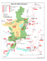
The southern and eastern parts of Mount St. Helens are reached by special U.S. Forest Service roads. These roads lead to many interesting places.
Here are some of the main roads:
 Forest Service Road 25: Connects from U.S. Route 12 to Road 90.
 Forest Service Road 26: Leads from Road 99 to Norway Pass and then to Road 25.
 Forest Service Road 81: Goes from SR 503/Road 90 to Merrill Lake and the Climber's Bivouac.
 Forest Service Road 83: Takes you from Road 90 to Ape Cave, Ape Canyon, and Lava Canyon.
 Forest Service Road 90: An entrance to the monument from State Route 503.
 Forest Service Road 99: Connects from Road 25 to Bear Meadows, Meta Lake, and Windy Ridge.
Bear Meadows
Bear Meadows is a beautiful open area with great views northeast of Mount St. Helens. It's located on Forest Service Road 99. This spot is famous because a photographer named Gary Rosenquist was camping here in 1980. He took many amazing photos of the eruption as it happened. He and his friends had to quickly leave for safety, but he kept taking pictures as they drove away.
Windy Ridge
Windy Ridge offers one of the closest views of the volcano that the public can reach. You can drive to Windy Ridge on Forest Service Road 99. It's only about 4 miles (6.4 km) northeast of the volcano's crater. From here, you can look over Spirit Lake. You'll see the damage from the eruption, but also how quickly the land is recovering. Plants are growing back, and wildlife is returning.
Ape Cave

Ape Cave is a fascinating lava tube located south of Mount St. Helens. It's the longest continuous lava tube in the continental United States. A lava tube is like a natural tunnel formed when hot, flowing lava cools on the outside, creating a crust, while the lava inside keeps flowing away.
This cave formed about 1,900 years ago. It's usually about 50 feet (15 meters) underground, and the air inside stays a cool 42°F (5.5°C) all year.
A logger discovered the cave in 1947. Later, a local Boy Scout troop, called the Mount St. Helens Apes, explored it. That's how the cave got its name!
Ape Cave is a very popular place for hiking. The Ape Cave Trail No. 239 runs inside the cave and is a National Recreation Trail. About 170,000 visitors explore it every year.
Trails and Recreation
Some trails around Spirit Lake were closed on weekdays in 2024. This was due to a project to fix a drainage tunnel built in 1985. These trail closures are expected to continue through 2027.
Images for kids
-
Map of the site

