Cowlitz County, Washington facts for kids
Quick facts for kids
Cowlitz County
|
|
|---|---|

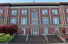
Cowlitz County Courthouse
|
|

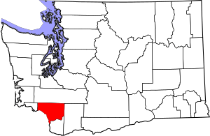
Location within the U.S. state of Washington
|
|
 Washington's location within the U.S. |
|
| Country | |
| State | |
| Founded | April 21, 1854 |
| Seat | Kelso |
| Largest city | Longview |
| Area | |
| • Total | 1,166 sq mi (3,020 km2) |
| • Land | 1,140 sq mi (3,000 km2) |
| • Water | 26 sq mi (70 km2) 2.2%% |
| Population
(2020)
|
|
| • Total | 110,730 |
| • Estimate
(2022)
|
111,956 |
| • Density | 94.97/sq mi (36.666/km2) |
| Time zone | UTC−8 (Pacific) |
| • Summer (DST) | UTC−7 (PDT) |
| Congressional district | 3rd |
Cowlitz County is a county located in the U.S. state of Washington. In 2020, about 110,730 people lived here. The main city and county seat is Kelso. The largest city is Longview.
The county was created in April 1854. Its name comes from the Cowlitz Indian term Cow-e-liske. This name means 'river of shifting sands' or 'capturing the medicine spirit.' Cowlitz County is part of the larger Portland-Vancouver-Salem area.
Contents
History
Early Inhabitants
Before Europeans arrived, many Native Americans lived in this area. The Cowlitz tribe was the largest group. They loved the region because there was a lot of salmon. The Cowlitz people were known for trading with other tribes across Washington. Sadly, many Cowlitz people died from a smallpox outbreak in 1829-1830.
European Exploration
European explorers first sailed up the Columbia River in 1792. British Lieutenant W. R. Broughton explored past where Cowlitz County is today. Later, on November 5, 1805, Lewis and Clark camped near the Kalama River. In the next few days, they explored the areas that are now Kelso and Longview.
Fur Trade and Settlement
By the 1820s, the Hudson's Bay Company started a big fur trade here. Furs were sent down the Cowlitz River to the Columbia River. From there, they traveled all over the world. But the fur trade slowed down in the late 1830s. This was because too many animals had been hunted, and fur clothing became less popular.
Over the next few decades, many white settlers moved to the region. Most settlers built homes near the rivers that flowed into the Columbia River. They formed small towns. The first town was Monticello, close to today's Longview. In 1841, several families from the Red River Colony settled there.
Forming Washington Territory
On November 25, 1852, settlers met in Monticello. They asked the government to create a new territory north of the Columbia River. This petition was called the Monticello Convention. It worked! Three months later, the United States Congress formed the Columbia Territory. It was soon renamed Washington Territory.
When the new Washington Territory started, it had two counties. These were Vancouver County and Lewis County. In 1849, Vancouver County was renamed Clark County. One of the first things the new Washington government did was create Cowlitz County. This happened on April 24, 1854. Governor Isaac Stevens signed the law. Later in 1854, the western part of Cowlitz County became Wahkiakum County. Since then, the county's borders have stayed the same.
Timber Industry
Almost every town that grew in the late 1800s started because of logging or lumber-milling. In the 1920s, the Weyerhaeuser Company and Long-Bell Lumber Company built huge wood processing factories. At that time, these were the largest in the world! Even today, the timber industry is very important to Cowlitz County.
County Seats Over Time
Cowlitz County has had four different county seats:
- Monticello (1854–1865)
- Freeport (1865–1872)
- Kalama (1872–1922)
- Kelso (1922–Present)
Geography
Cowlitz County is in the southwest part of Washington state. It covers about 1,166 square miles. Most of this area (1,140 square miles) is land, and 26 square miles (2.2%) is water.
The county is part of a long valley called the Puget Sound – Willamette Depression. This valley stretches from Puget Sound in Washington to the Willamette Valley in Oregon. Many of the county's big rivers start in the nearby Cascade Mountains. These include the Columbia, Cowlitz, Coweeman, Kalama, Lewis, and Toutle rivers.
Cowlitz County is one of the smaller counties in Washington. It is the 28th largest out of 39 counties.
Geographic Features
Major Highways
Neighboring Counties
- Lewis County - north
- Skamania County - east
- Clark County - south
- Wahkiakum County - west
- Columbia County - south
Protected Areas
County Parks
- Catlin Cemetery
- Cougar Wayside
- Finn Hall Wayside
- Harry Gardner Park
- Hog Island Access
- Riverside Park
- SRS Viewpoint
- Woodbrook Park
Demographics
| Historical population | |||
|---|---|---|---|
| Census | Pop. | %± | |
| 1860 | 406 | — | |
| 1870 | 730 | 79.8% | |
| 1880 | 2,062 | 182.5% | |
| 1890 | 5,917 | 187.0% | |
| 1900 | 7,877 | 33.1% | |
| 1910 | 12,561 | 59.5% | |
| 1920 | 11,791 | −6.1% | |
| 1930 | 31,906 | 170.6% | |
| 1940 | 40,155 | 25.9% | |
| 1950 | 53,369 | 32.9% | |
| 1960 | 57,801 | 8.3% | |
| 1970 | 68,616 | 18.7% | |
| 1980 | 79,548 | 15.9% | |
| 1990 | 82,119 | 3.2% | |
| 2000 | 92,948 | 13.2% | |
| 2010 | 102,410 | 10.2% | |
| 2020 | 110,730 | 8.1% | |
| 2022 (est.) | 111,956 | 9.3% | |
| U.S. Decennial Census 1790–1960 1900–1990 1990–2000 2010–2020 |
|||
Population in 2020
In 2020, Cowlitz County had 110,730 people and 42,776 households. The population density was about 97 people per square mile. Most people (90.4%) were White. About 9.9% of the population was of Hispanic or Latino origin.
About 22.5% of the people in the county were under 18 years old. About 19.4% were over 65 years old. The number of males and females was almost equal. The average income for a household was $64,506. About 12.6% of the people lived below the poverty line.
Population in 2010
In 2010, there were 102,410 people living in the county. The population density was about 89.8 people per square mile. Most people (88.9%) were white. About 7.8% of the population was of Hispanic or Latino origin.
Of the households, 31.8% had children under 18 living with them. The average age of people in the county was 40.2 years. The average income for a household was $45,877. About 16.9% of the population lived below the poverty line. This included 23.3% of those under 18.
Communities
Cities
- Castle Rock
- Kalama
- Kelso (County seat)
- Longview
- Woodland (Partly in Clark County)
Census-designated places
- Beacon Hill
- Cougar
- Lexington
- Longview Heights
- Ryderwood
- West Side Highway (former)
Unincorporated communities
See also
 In Spanish: Condado de Cowlitz para niños
 | Emma Amos |
 | Edward Mitchell Bannister |
 | Larry D. Alexander |
 | Ernie Barnes |

