
Lewis County, Washington facts for kids
Quick facts for kids
Lewis County
|
|
|---|---|

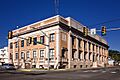
Lewis County Historic Courthouse
|
|

Location within the U.S. state of Washington
|
|
 Washington's location within the U.S. |
|
| Country | |
| State | |
| Founded | December 19, 1845 |
| Named for | Meriwether Lewis |
| Seat | Chehalis |
| Largest city | Centralia |
| Area | |
| • Total | 2,436 sq mi (6,310 km2) |
| • Land | 2,403 sq mi (6,220 km2) |
| • Water | 33 sq mi (90 km2) 1.4%% |
| Population
(2020)
|
|
| • Total | 82,149 |
| • Estimate
(2023)
|
86,154 |
| • Density | 32.5/sq mi (12.5/km2) |
| Time zone | UTC−8 (Pacific) |
| • Summer (DST) | UTC−7 (PDT) |
| Congressional district | 3rd |
Lewis County is a county in the state of Washington. In 2020, about 82,149 people lived here. The main city where the county government is located is Chehalis. The biggest city in the county is Centralia. Lewis County is part of a larger area that includes Seattle and Tacoma.
Contents
History of Lewis County
Lewis County was first created on December 19, 1845. It was first called Vancouver County, named after George Vancouver. But in 1849, its name was changed to honor Meriwether Lewis. He was a famous explorer. Even though the county is named after him, Meriwether Lewis never actually visited this area.
The first county seat, or main government town, was Claquato in 1862. Later, in 1874, Chehalis became the county seat. The very first court hearing in the Washington Territory happened in Lewis County. It was held at the John R. Jackson Courthouse. This is the oldest courthouse still standing in Washington.
In November 2019, Lewis County was officially recognized as a "Purple Heart County." This means it honors military members who have been wounded in battle.
Geography of Lewis County
Lewis County is located along the Interstate 5 highway. It shares its borders with eight other counties. These are Grays Harbor, Thurston, Pierce, Yakima, Skamania, Cowlitz, Wahkiakum, and Pacific counties.
The county covers about 2,436 square miles. Most of this area, 2,403 square miles, is land. The rest, 33 square miles, is water. Lewis County was once home to one of the world's tallest Douglas fir trees. It was in the town of Mineral and stood about 120 meters (394 feet) tall.
Geographic Features
Lewis County has many interesting natural features:
- Cascade Mountains
- Chehalis River and its smaller rivers like the South Fork Chehalis River, Newaukum River, and Skookumchuck River.
- Cowlitz River and its smaller rivers like the Ohanapecosh River, Cispus River, and Tilton River.
- Nisqually River
- Lake Mayfield
- Riffe Lake
- Big Horn, which is the highest point in Lewis County.
- Boistfort Peak, the highest point in the Willapa Hills.
- Walupt Creek Falls
Major Highways
These are the main roads that go through Lewis County:
 Interstate 5
 U.S. Route 12
 State Route 6
 State Route 7
Neighboring Counties
- Grays Harbor County – to the north and northwest
- Thurston County – to the north
- Pierce County – to the north and northeast
- Yakima County – to the east
- Skamania County – to the south and southeast
- Cowlitz County – to the south
- Wahkiakum County – to the south and southwest
- Pacific County – to the west
Protected Natural Areas
Parts of these important natural areas are found in Lewis County:
- Gifford Pinchot National Forest
- Mount Baker-Snoqualmie National Forest
- Mount Rainier National Park
- Mount St. Helens National Volcanic Monument
- Goat Rocks Wilderness
Communities in Lewis County
Lewis County has several cities, one town, and a few census-designated places.
Cities
Town
Census-Designated Places
These are areas that are like towns but are not officially incorporated as cities:
Population of Lewis County
| Historical population | |||
|---|---|---|---|
| Census | Pop. | %± | |
| 1850 | 558 | — | |
| 1860 | 384 | −31.2% | |
| 1870 | 888 | 131.3% | |
| 1880 | 2,600 | 192.8% | |
| 1890 | 11,499 | 342.3% | |
| 1900 | 15,157 | 31.8% | |
| 1910 | 32,127 | 112.0% | |
| 1920 | 36,840 | 14.7% | |
| 1930 | 40,034 | 8.7% | |
| 1940 | 41,393 | 3.4% | |
| 1950 | 43,755 | 5.7% | |
| 1960 | 41,858 | −4.3% | |
| 1970 | 45,467 | 8.6% | |
| 1980 | 56,025 | 23.2% | |
| 1990 | 59,358 | 5.9% | |
| 2000 | 68,600 | 15.6% | |
| 2010 | 75,455 | 10.0% | |
| 2020 | 82,149 | 8.9% | |
| 2023 (est.) | 86,154 | 14.2% | |
| U.S. Decennial Census 1790–1960 1900–1990 1990–2000 2010–2020 |
|||
In 2010, Lewis County had 75,455 people living there. The population density was about 31.4 people per square mile. Most people in the county were white (89.7%). About 8.7% of the population was of Hispanic or Latino background. The average age of people in Lewis County was 41.5 years old.
Helping People Without Homes
Lewis County takes part in a yearly count of people who do not have a stable home. This count is called the Point In Time Count. It helps the county understand how many people need housing support. In 2023, 153 people were counted as not having a stable home. This count does not include students who might be in a difficult housing situation. However, in 2018, about 558 students were identified as needing housing support.
Economy of Lewis County
| Rank | Employer | Type of business | Number of employees |
|---|---|---|---|
| 1 | Providence Centralia Hospital | Health care | 900 |
| 2 | United Natural Foods | Food Wholesale/Distribution | 750 |
| 3 | Walmart | Retail | 653 |
| 4 | Lewis County | Government | 624 (2021) |
| 5 | Centralia School District | Education | 530 |
| 6 | Centralia College | Education | 472 |
| 7 | Chehalis School District | Education | 420 |
| 8 | Michaels | Distribution/Warehouse | 310 (2021) |
| 9 | Hamptons Lumber Mills | Timber | 305 |
| 10 | Braun Northwest, Inc. | Manufacturing | 275 |
The economy in Lewis County relies a lot on lumber production. The county produces a large amount of dried timber each year. It also has plants that make pulpwood. Lewis County is also a big producer of Christmas trees in the United States. In 2022, it grew over 548,000 Christmas trees.
Farming is another important part of the county's economy. Many people also work in mining, manufacturing, and warehousing.
Tourism also brings a lot of money to Lewis County. In 2023, over 5.6 million people visited the county. Many visitors come to see Mount Rainier and to shop in the cities of Centralia and Chehalis. The county works to promote tourism by highlighting its towns and cities.
Arts and Culture
Art
Lewis County is home to the ARTrails of Southwest Washington. This group started in 2003. It helps show off local artists, art studios, and galleries. Every fall, they hold a studio tour where people can visit different art spaces. The Lewis County Historical Museum has a special gallery for ARTrails.
Charitable Organizations
The Lewis County branch of the American Association of University Women (AAUW) has been active since 1923. This group holds a yearly used book sale. The money raised helps fund scholarships for young women. It also supports day camps and career days for middle and high school girls.
Education in Lewis County
Lewis County is home to Centralia College. It was founded in 1925 and is located in Centralia. It is the oldest community college in Washington state that has been open continuously.
Parks and Recreation

Lewis County manages many parks and recreation areas. As of 2022, the county oversees about 164 acres of parks. These areas include Back Memorial Park and Rose Parks in Adna. Other parks are Schaefer County Park in Centralia and Cowlitz River Park in Packwood. Historic sites like Claquato Church and St. Urban Church are also managed by the county. The county also has historical markers that honor the travels of pioneer Ezra Meeker on the Oregon Trail.
The Lewis County Historic Bike Ride is a yearly event in the spring. It started in the early 1990s as a historical celebration. Riders can choose different routes that go through small towns and communities. The ride often serves as practice for the Seattle to Portland Bicycle Classic (STP). In 2010, the county decided that all its parks would be "No Shooting Zones."
Infrastructure
The Lewis County Public Utility District (LCPUD) provides electricity to the county. In 2024, the LCPUD also started offering high-speed broadband internet. This project is for people in rural areas of the county. It is expected to be finished by late 2027.
Renewable Energy
Lewis County is part of the Pacific Northwest Hydrogen Hub (PNW H2) project. This project aims to produce and store hydrogen fuels. It could also lead to making hydrogen fuel products like vehicles. The PNW H2 has given money to schools, Centralia College, and energy companies in the county. Lewis County Transit also received money from this program. It is the only transit agency in the United States to get this funding.
The Skookumchuck Wind Farm is in Lewis County. It has 38 wind turbines that can create a lot of electricity. The wind farm started working in late 2020. The energy it produces is used by Puget Sound Energy's Green Direct program.
Images for kids
-
Lewis County Historic Courthouse
See also
 In Spanish: Condado de Lewis (Washington) para niños
