Pacific County, Washington facts for kids
Quick facts for kids
Pacific County
|
|
|---|---|

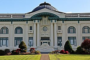
Pacific County Courthouse, South Bend
|
|

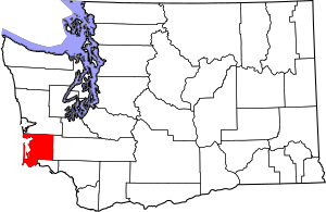
Location within the U.S. state of Washington
|
|
 Washington's location within the U.S. |
|
| Country | |
| State | |
| Founded | February 4, 1851 |
| Named for | Pacific Ocean |
| Seat | South Bend |
| Largest city | Raymond |
| Area | |
| • Total | 1,223 sq mi (3,170 km2) |
| • Land | 933 sq mi (2,420 km2) |
| • Water | 291 sq mi (750 km2) 24%% |
| Population
(2020)
|
|
| • Total | 23,365 |
| • Estimate
(2023)
|
24,200 |
| • Density | 19/sq mi (7/km2) |
| Time zone | UTC−8 (Pacific) |
| • Summer (DST) | UTC−7 (PDT) |
| Congressional district | 3rd |
Pacific County is a county in the state of Washington. In 2020, about 23,365 people lived there. The main town, called the county seat, is South Bend. The biggest city in the county is Raymond.
This county was created in February 1851. It was named after the huge Pacific Ocean nearby. Pacific County is famous for Willapa Bay. This bay provides a lot of the oysters eaten in the United States. In fact, it produces about one-quarter of all U.S. oysters! Other important jobs in the county include forestry, fishing, and tourism.
Contents
A Look Back: Pacific County's History
The land that is now Pacific County was once part of Oregon Territory. This was in the early 1800s. In 1845, the government of Oregon created two counties in this northern area. These were Vancouver and Clark counties.
Later, in 1849, Vancouver County changed its name to Lewis County. Then, on February 4, 1851, a part of Lewis County became Pacific County. The borders of Pacific County have stayed the same ever since.
The county seat, or main town, moved a few times. First, it was Pacific City. When the U.S. military took over Pacific City, the county seat moved to Chinookville.
Then, Oysterville became the county seat in 1852. But in 1893, something exciting happened! People from South Bend secretly took the county records from Oysterville. They carried them across Willapa Harbor. Because of this, South Bend became the new county seat.
Where is Pacific County?
Pacific County covers about 1,223 square miles. Most of this area is land, about 933 square miles. The rest, about 291 square miles, is water. This means about 24% of the county is water!
Cool Places to See
- Cape Disappointment: A famous cape at the mouth of the Columbia River.
- Columbia River: A very long river that forms part of the county's southern border.
- Long Beach Peninsula: A long, sandy peninsula popular for beaches and tourism.
- Long Island: An island in Willapa Bay.
- Willapa Bay: A large bay known for its oysters.
Main Roads
- U.S. Route 101: A major highway that runs through the county.
- State Route 6: Another important road in the area.
Neighboring Counties
Pacific County shares borders with other counties:
- Grays Harbor County to the north.
- Lewis County to the east.
- Wahkiakum County to the southeast.
- Clatsop County, Oregon to the south, in Oregon.
Protected Natural Areas
- Lewis and Clark National Historical Park: Part of this park is in Pacific County.
- Willapa National Wildlife Refuge: A special place to protect wildlife.
Who Lives in Pacific County?
| Historical population | |||
|---|---|---|---|
| Census | Pop. | %± | |
| 1860 | 420 | — | |
| 1870 | 738 | 75.7% | |
| 1880 | 1,645 | 122.9% | |
| 1890 | 4,358 | 164.9% | |
| 1900 | 5,983 | 37.3% | |
| 1910 | 12,532 | 109.5% | |
| 1920 | 14,891 | 18.8% | |
| 1930 | 14,970 | 0.5% | |
| 1940 | 15,928 | 6.4% | |
| 1950 | 16,558 | 4.0% | |
| 1960 | 14,674 | −11.4% | |
| 1970 | 15,796 | 7.6% | |
| 1980 | 17,237 | 9.1% | |
| 1990 | 18,882 | 9.5% | |
| 2000 | 20,984 | 11.1% | |
| 2010 | 20,920 | −0.3% | |
| 2020 | 23,365 | 11.7% | |
| 2023 (est.) | 24,200 | 15.7% | |
| U.S. Decennial Census 1790–1960 1900–1990 1990–2000 2010–2020 |
|||
In 2010, about 20,920 people lived in Pacific County. Most people, about 87.4%, were white. About 8.0% of the people were of Hispanic or Latino background. The average age of people living there was about 50.8 years old.
Towns and Communities
Here are some of the places where people live in Pacific County:
Cities
- Ilwaco
- Long Beach
- Raymond
- South Bend (This is the county seat!)
Census-Designated Places (CDPs)
These are areas that are like towns but are not officially cities.
Other Communities
These are smaller, unincorporated communities.
- Dexter by the Sea
- Firdale
- Frances
- Holcomb
- Megler
- Menlo
- Nemah
- North Cove
- Oceanside
- Old Willapa
- Oysterville
- Pluvius
- Seaview
- Surfside
Images for kids
See also
 In Spanish: Condado de Pacific para niños
 | Precious Adams |
 | Lauren Anderson |
 | Janet Collins |


