Oregon Territory facts for kids
Quick facts for kids Territory of Oregon |
|||||||||||
|---|---|---|---|---|---|---|---|---|---|---|---|
| Organized incorporated territory of the United States | |||||||||||
| 1846–1859 | |||||||||||
|
Seal of the Oregon Territory
|
|||||||||||
| Capital |
|
||||||||||
| Government | |||||||||||
| • Type | Organized incorporated territory | ||||||||||
| • Motto | Alis volat propriis | ||||||||||
| Governor | |||||||||||
|
• 1848–1850; 1853
|
Joseph Lane | ||||||||||
|
• 1850
|
Kintzing Prichette | ||||||||||
|
• 1850–1853
|
John P. Gaines | ||||||||||
|
• 1853–1854
|
John W. Davis | ||||||||||
|
• 1854–1859
|
George L. Curry | ||||||||||
| History | |||||||||||
| June 15, 1846 | |||||||||||
|
• Organized
|
14 August 1846 | ||||||||||
|
• Washington Territory split off
|
March 2, 1853 | ||||||||||
| 14 February | |||||||||||
|
|||||||||||
The Territory of Oregon was a special area of the United States that was set up by the government. It existed from August 14, 1848, until February 14, 1859. On that date, a part of the territory became the State of Oregon.
Before it became a U.S. territory, this large area was called the Oregon Country. Several countries, including Spain, Britain, and the U.S., claimed it. In 1846, Britain and the U.S. agreed to divide the land.
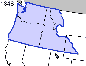
When the Oregon Territory was created, it included all of what are now the states of Oregon, Washington, and Idaho. It also included parts of Wyoming and Montana. The capital city of the territory changed several times. It started in Oregon City, then moved to Salem, briefly to Corvallis, and finally back to Salem. Salem became the capital when Oregon became a state.
Early History of the Oregon Country
Long ago, Native Americans lived in the region that would become the Oregon Territory. European explorers first visited the area by sea. Spanish explorers arrived in 1777. British and American ships also came soon after.
Later, explorers like Alexander Mackenzie and the Lewis and Clark Expedition explored the land. The fur trade also grew in the region. These activities made both Great Britain and the United States want to claim the land.
To avoid conflict, Britain and the U.S. signed the Treaty of 1818. This treaty allowed both countries to share the "Oregon Country." This huge area included what are now Oregon, Washington, and Idaho. It also covered parts of Montana and Wyoming, and a part of British Columbia in Canada.
How the Territory Was Formed
During the time Britain and the U.S. shared the land, most people living there were Native Americans. Other activities mainly involved the fur trade. The British Hudson's Bay Company was very powerful in this trade.
Over time, some fur trappers started to settle down and farm. Missionaries also began to arrive in the 1830s. More settlers came in the late 1830s. Covered wagons started traveling the Oregon Trail in 1841. At this time, only local Native American communities had governments. No single country fully controlled the area.
In 1841, a group of settlers in the Willamette Valley started meeting. They wanted to create a government for the area. These early meetings happened in a place called Champoeg, Oregon. These Champoeg Meetings led to more discussions. In 1843, they created the Provisional Government of Oregon.
In 1846, the U.S. and Britain finally settled their land dispute. They signed the Oregon Treaty. This treaty set the border between their lands.
The U.S. government did not organize its part of the region for two years. But then, news of the Whitman massacre reached the United States Congress. This event helped Congress decide to organize the region. On August 14, 1848, Congress passed a law to create the Territory of Oregon.
The Oregon Territory first included all of present-day Idaho, Oregon, and Washington. It also had parts of Montana and Wyoming west of the Continental Divide. Its southern border was at 42 degrees north latitude. This was the boundary from the Adams-Onis Treaty of 1819. The territory stretched north to 49 degrees north latitude. Oregon City, Oregon was chosen as the first capital.
Becoming a State
Oregon City was the capital from 1848 to 1851. Then, Salem became the capital from 1851 to 1855. Corvallis was briefly the capital in 1855. Later that year, the capital moved back to Salem permanently.
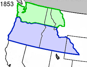
In 1853, a new territory was created from the northern part of Oregon Territory. This new area was called the Washington Territory. It included the land north of the lower Columbia River. This change was approved by Congress and President Millard Fillmore.
In 1857, leaders held the Oregon Constitutional Convention. They wrote a constitution to prepare for Oregon to become a state. The delegates approved the document in September. Then, the people of the territory voted to approve it in November.
In 1850, the Oregon Territory had a population of 13,294 people. The table below shows the population of the ten largest counties at that time:
| Rank | County | Population |
|---|---|---|
| 1 | Marion | 2,749 |
| 2 | Washington | 2,652 |
| 3 | Clackamas | 1,859 |
| 4 | Yamhill | 1,512 |
| 5 | Polk | 1,051 |
| 6 | Linn | 994 |
| 7 | Benton | 814 |
| 8 | Clark | 643 |
| 9 | Lewis | 558 |
| 10 | Clatsop | 462 |
| Oregon Territory | 13,294 |
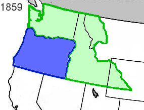
On February 14, 1859, Oregon officially became a U.S. state. It joined the Union with its current borders. The remaining eastern parts of the old territory, in what is now southern Idaho and western Wyoming, were added to the Washington Territory.
See also
 In Spanish: Territorio de Oregón (Estados Unidos) para niños
 | William L. Dawson |
 | W. E. B. Du Bois |
 | Harry Belafonte |


