
Adams–Onís Treaty facts for kids
| Treaty of Amity, Settlement and Limits between the United States of America, and His Catholic Majesty | |
|---|---|

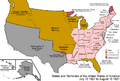
Map showing results of the Adams–Onís Treaty.
|
|
| Type | Bilateral treaty |
| Context | Territorial cession |
| Signed | February 22, 1819 |
| Location | Washington, D.C. |
| Effective | February 22, 1821 |
| Expiry | April 14, 1903 |
| Parties | |
| Citations | 8 Stat. 252; TS 327; 11 Bevans 528; 3 Miller 3 |
| Languages | English, Spanish |
| Terminated by the treaty of friendship and general relations of July 3, 1902 (33 Stat. 2105; TS 422; 11 Bevans 528). | |
The Adams–Onís Treaty (also called the Transcontinental Treaty or Florida Purchase Treaty) was an important agreement signed in 1819. It was between the United States and Spain. This treaty gave Florida to the U.S. and clearly set the border between the U.S. and New Spain (which is now mostly Mexico). It helped solve a long-standing argument about where the two countries' lands ended. Many people saw it as a big win for American diplomacy.
At the time, Spain found it hard to manage Florida. They couldn't afford to send many people or soldiers there. So, Spain decided to give Florida to the United States. In return, the U.S. agreed to settle the border along the Sabine River in Spanish Texas. The treaty also drew the U.S. border all the way through the Rocky Mountains to the Pacific Ocean. The U.S. also agreed to pay up to $5 million to its citizens who had claims against the Spanish government. The U.S. also gave up its claims to parts of Spanish Texas and other Spanish areas that it thought were part of the Louisiana Purchase.
The treaty was fully active for only a short time, from February 22 to August 24, 1821. This was because Spanish military leaders signed the Treaty of Córdoba, which recognized Mexico's independence. Even though Spain didn't officially agree to the Treaty of Córdoba, Mexico took control of the former Spanish colony. Later, in 1828, Mexico and the United States signed the Treaty of Limits. This treaty confirmed the border set by the Adams–Onís Treaty as the boundary between Mexico and the U.S.
Contents
History of the Treaty
The Adams–Onís Treaty was worked out by John Quincy Adams, who was the Secretary of State (a top government official) for U.S. President James Monroe. The Spanish side was represented by Luis de Onís y González-Vara, a special diplomat from King Ferdinand VII.
Why Florida Was Important


Spain had said no many times when America tried to buy Florida. But by 1818, Spain had many problems with its colonies. Giving up Florida seemed like a good idea. Spain was tired from fighting Napoleon in Europe (the Peninsular War). It needed to focus on its other colonies, where people were fighting for independence.
Spain didn't want to spend more money on Florida. American settlers were moving into the area. Also, Spain was worried about the border between New Spain (a huge area including modern-day Mexico and parts of the U.S.) and the United States. Spain had very few soldiers in Florida. This meant they couldn't stop Seminole warriors from crossing the border. These warriors would raid American towns and farms in Georgia. They also offered safety to enslaved people who had escaped from southern U.S. states.
From 1810 to 1813, the United States took over most of West Florida. They claimed it was part of the Louisiana Purchase. During the War of 1812, General James Wilkinson took over Mobile. Spain never got back the part of West Florida west of the Perdido River.
Spain also struggled to control the inner parts of East Florida. Their presence was mostly limited to coastal cities like St. Augustine. The interior was largely controlled by the Seminole people.
During the First Seminole War, American General Andrew Jackson chased Native Americans and escaped enslaved people into Spanish Florida. He built Fort Scott near the Georgia border. From there, he destroyed the "Negro Fort" in Florida. This fort was seen as a danger by plantation owners in Georgia because it offered a safe place for runaway slaves.
To stop the Seminole from raiding Georgia and helping runaway slaves, the U.S. Army often went into Spanish territory. Andrew Jackson's campaign in 1817–1818, known as the First Seminole War, led the U.S. to effectively take control of Florida. John Quincy Adams said the U.S. had to take control because Florida was "a place open to every enemy... of the United States." Spain asked Britain for help, but Britain refused. Some U.S. officials wanted Jackson fired for invading Florida. But Adams realized Jackson's actions put the U.S. in a strong position to negotiate a good deal.
The Louisiana Border Dispute

In 1521, Spain created the "Viceroyalty of New Spain" to rule its lands in the Americas. In 1682, a French explorer named La Salle claimed Louisiana for France. Spain saw this as an invasion of its lands. To stop French settlement, Spain created the Province of Tejas in 1691.
In 1762, France secretly gave Louisiana to Spain. Then, in 1763, the Treaty of Paris split Louisiana. The part east of the Mississippi River went to Britain, and the part west went to Spain. This removed the French threat. The Spanish areas of Louisiana, Tejas, and New Mexico then existed with unclear borders.
In 1800, French leader Napoleon Bonaparte forced Spain to give Louisiana back to France. Spain continued to manage Louisiana until 1802. The next year, Napoleon sold the territory to the United States. This was known as the Louisiana Purchase.
After the Louisiana Purchase in 1803, the United States and Spain disagreed about the exact borders. The U.S. claimed that Louisiana included the Mississippi River and all lands whose waters flowed into it. West of New Orleans, the U.S. claimed all land east and north of the Sabine River or the Rio Grande. Spain, however, said that all land west of the Calcasieu River and south of the Arkansas River belonged to its provinces of Tejas and New Mexico.
Claims in the Oregon Country

Several countries claimed the land west of the Continental Divide (the line of mountains that separates rivers flowing east from rivers flowing west). This area was between Spain's Alta California and Russia's Alaska.
- Britain claimed it based on explorations by James Cook, George Vancouver, Alexander Mackenzie, and David Thompson.
- The United States claimed it based on Robert Gray's trip up the Columbia River, the Lewis and Clark Expedition, and the building of Fort Astoria in 1811.
In 1818, the U.S. and Britain agreed to share this region. This agreement, called the Anglo-American Convention of 1818, set the border east of the Continental Divide at the 49th parallel north. West of the divide, they agreed to share the land. This agreement didn't include Spain or Russia, who also had claims. The U.S. called this area the Oregon Country, while the British called it the Columbia District.
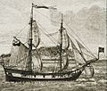
Russian Claims in America

.jpg)
In 1741, Russian explorers landed in northwestern North America. This led to the Russian fur trade. By 1812, the Russian Empire claimed Alaska and the Pacific Coast as far south as Fortress Ross, which was only about 105 kilometers (65 miles) northwest of Spain's Presidio Real de San Francisco.
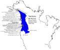
Spanish Claims in New Spain

.png)
.png)
The Spanish Empire claimed all lands west of the Continental Divide throughout the Americas. Between 1774 and 1779, King Charles III of Spain sent ships north along the Pacific Coast to claim these lands. Spanish explorers reached as far north as what is now Hinchinbrook Island in Alaska.
Between 1788 and 1793, Spain sent more expeditions north of Alta California. In 1789, Spain set up a colony called Santa Cruz de Nuca on Vancouver Island. Spain claimed it had exclusive rights there and seized several ships. This led to the Nootka Crisis with Great Britain. To solve this, Spain and Britain signed the Third Nootka Convention in 1794. They agreed to abandon permanent settlements at Nootka Sound and allow both nations to use it.
East of the Continental Divide, Spain claimed all land south of the Arkansas River and west of the Calcasieu River. The large area between the U.S. and Spanish claims was mostly home to native peoples. The region between the Calcasieu and Sabine rivers became a lawless "no man's land." The United States saw great potential in these western lands and wanted clear borders. Spain, seeing its control over New Spain weakening, wanted to secure its claims before Mexico gained independence.
Details of the Treaty Agreement

The treaty had 16 articles and was signed in Washington, D.C., on February 22, 1819. The signers were John Quincy Adams for the U.S. and Luis de Onís y González-Vara for Spain. Spain delayed approving the treaty for two years. They hoped this would stop the U.S. from supporting the independence movements in South America.
The U.S. Senate quickly approved the treaty. But because Spain delayed, a new approval was needed. Some, like Henry Clay, wanted Spain to also give up Texas. This idea was rejected. The Senate approved the treaty again in February 1821, after Spain finally approved it in October 1820. The treaty officially began on February 22, 1821.
The treaty marked the end of the first period of U.S. expansion.
- Under Article 2, the U.S. gained East Florida.
- It also settled the argument over West Florida, part of which the U.S. had already taken.
- Article 3 defined the border with New Spain, making Texas clearly part of it. This cleared up much of the confusion about the Louisiana Purchase border.
- Spain also gave up its claims to the Oregon Country to the U.S. under Article 3.
The U.S. did not pay Spain directly for Florida. Instead, under Article 11, the U.S. agreed to pay its own citizens' legal claims against Spain, up to $5 million. The Pinckney's Treaty of 1795 between the U.S. and Spain remained in effect (Article 12). For twelve years, Spanish goods received special trade benefits in the ports of Pensacola and St. Augustine (Article 15).
The New Border Line
Article 3 of the treaty described the new border:
The Boundary Line between the two Countries, West of the Mississippi, shall begin on the Gulf of Mexico, at the mouth of the River Sabine in the Sea (29°40′42″N 93°50′03″W / 29.67822°N 93.83430°W), continuing North, along the Western Bank of that River, to the 32d degree of Latitude (32°00′00″N 94°02′45″W / 32°N 94.04574°W); thence by a Line due North to the degree of Latitude, where it strikes the Rio Roxo of Nachitoches, or Red-River (33°33′04″N 94°02′45″W / 33.55112°N 94.04574°W), then following the course of the Rio-Roxo Westward to the degree of Longitude, 100 West from London and 23 from Washington (34°33′37″N 100°00′00″W / 34.56038°N 100°W), then crossing the said Red-River, and running thence by a Line due North to the River Arkansas (37°44′38″N 100°00′00″W / 37.74375°N 100°W), thence, following the Course of the Southern bank of the Arkansas to its source in Latitude, 42. North and thence by that parallel of Latitude to the South-Sea [Pacific Ocean]. The whole being as laid down in Melishe's Map of the United States, published at Philadelphia, improved to the first of January 1818. But if the Source of the Arkansas River shall be found to fall North or South of Latitude 42, then the Line shall run from the said Source (39°15′30″N 106°20′38″W / 39.2583225°N 106.3439141°W) due South or North, as the case may be, till it meets the said Parallel of Latitude 42 (42°00′00″N 106°20′38″W / 42°N 106.3439141°W), and thence along the said Parallel to the South Sea (42°00′00″N 124°12′46″W / 42°N 124.21266°W).
When the treaty was signed, the exact paths of the Sabine, Red, and Arkansas Rivers were not fully known. Also, rivers can change course. It took many years to figure out the exact border.
- South of the 32nd parallel north, the border followed the Sabine River.
- Between certain longitudes, it followed the Red River.
- West of the 100th meridian west, it followed the Arkansas River.
- From the source of the Arkansas River in the Rocky Mountains, the border went north to the 42nd parallel north. Then it went west along the 42nd parallel to the Pacific Ocean.
Spain gained important buffer zones around its provinces of Tejas, New Mexico, and Alta California. The U.S. gave up some land east of the Continental Divide. But the new border allowed the U.S. to settle the southwestern part of the State of Louisiana, the Arkansas Territory, and the Missouri Territory.
Spain gave up all its claims in the Americas north of the 42nd parallel north. This was a big change after 327 years of claiming lands in the Americas. Because of the Anglo-American Convention of 1818, both American and British citizens could settle land north of the 42nd parallel and west of the Continental Divide. The U.S. now had a strong presence on the Pacific Coast. This meant it could start settling the jointly occupied Oregon Country.
For the United States, this treaty meant its claimed territory now stretched far west from the Mississippi River to the Pacific Ocean. For Spain, it meant keeping its colony of Texas and a buffer zone between its colonies in California and New Mexico and the U.S. Many historians believe the treaty was a great success for the U.S. It allowed the U.S. to open trade with Asia across the Pacific.
This new border was sometimes called the "Step Boundary" because of its zig-zag shape. However, this shape wasn't fully clear for many years. For example, the source of the Arkansas River was not known until the 1840s. It turned out to be hundreds of miles south of where people thought it was near the 42nd parallel north.
How the Treaty Was Carried Out
Washington set up a group from 1821 to 1824 to handle American citizens' claims against Spain. Many famous lawyers, like Daniel Webster, represented these citizens. The group looked at 1,859 claims and fairly distributed the $5 million.
The treaty helped reduce problems with Spain (and later Mexico). It also allowed the U.S. Congress to cut the army budget. The treaty was respected by both sides. However, because the maps used were not perfect, the border between Texas and Oklahoma remained unclear for most of the 1800s.
Later Events

Spain approved the treaty in 1820, and the United States in 1821. This was during the time Spain and Mexico were fighting the Mexican War of Independence.
Spain finally recognized Mexico's independence with the Treaty of Córdoba on August 24, 1821. Mexico was not originally part of the Adams–Onís Treaty. But in 1831, Mexico agreed to the border by signing the 1828 Treaty of Limits with the U.S.
With the Russo-American Treaty of 1824, Russia gave up its claims south of parallel 54°40′ north to the United States. In 1825, Russia set the southern border of Alaska at the same parallel. This set the final limits of the Oregon Country between the 42nd parallel north and the 54°40′ north parallel, west of the Continental Divide.
By the mid-1830s, a disagreement arose about the border with Texas. Maps had incorrectly switched the Sabine and Neches rivers, which moved the border in Mexico's favor. So, the eastern border of Texas was not firmly set until the Republic of Texas became independent in 1836. The U.S. and Mexico did not agree on it until the Treaty of Guadalupe Hidalgo in 1848, which ended the Mexican–American War. That treaty also officially gave Mexico's Alta California and today's American Southwest to the U.S.
Another border dispute happened after Texas joined the U.S. The treaty said the border between French (U.S.) and Spanish (Mexican) claims was the Red River until it reached the 100th meridian. But the 100th meridian on the John Melish map of 1818 was about 90 miles east of the true 100th meridian. Also, the Red River forked about 50 miles east of the 100th meridian. Texas claimed the land south of the North Fork, and the U.S. claimed the land north of the South Fork. In 1860, Texas organized the area as Greer County. This issue was not settled until a U.S. Supreme Court ruling in 1896. The ruling supported the federal claims, and the land was added to the Oklahoma Territory.
The treaty also led to a border dispute between the states of Oregon and California, which is still not fully resolved. When California became a state in 1850, it set the 42nd parallel as its official border, as it had been since 1819. But in an 1868–1870 survey, mistakes were made in marking the Oregon-California border. This created a disagreement that continues today.
In 2020, a false rumor spread in Spain that the Adams–Onís Treaty would expire in 2055 and Florida would return to Spain. This is not true.
See Also
 In Spanish: Tratado de Adams-Onís para niños
- List of treaties
- Spain–United States relations
- Spanish expeditions to the Pacific Northwest
- Stephen H. Long's Expedition of 1820, an outcome of the treaty
- Republic of East Florida
Images for kids
-

Map showing results of the Adams–Onís Treaty.
-
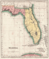
Spanish West Florida and East Florida from 1810 to 1821
-
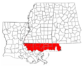
Part of West Florida that the United States claimed
-

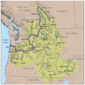
The Mississippi River Basin
-
The Columbia River Basin
-
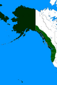
Russian claims in the Americas in green, 1812–1824
-
The Saint Peter sailboat
-
Spanish claims north of Alta California from 1789 to 1795
-
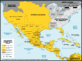
The Viceroyalty of New Spain in 1800. (Note: Many boundaries outside of New Spain are shown incorrectly.)
-
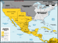
The Viceroyalty of New Spain in 1821, after the Adams–Onís Treaty took effect. (Note: Many boundaries outside of New Spain are shown incorrectly.)
-
The Adams–Onís Treaty
-
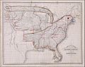
An 1833 map of the United States in the shape of an eagle
-
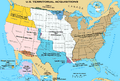
Territorial expansion of the United States

