
Neches River facts for kids
Quick facts for kids Neches River |
|
|---|---|
.jpg)
Neches River, looking into the Big Thicket National Preserve from Orange County, Texas, USA (October 2016)
|
|

Map of the Neches River and associated watershed
|
|
| Native name | Nachawi |
| Other name(s) | Río de las Neches |
| Physical characteristics | |
| Main source | East of Colfax, Texas 32°30′N 95°45′W / 32.500°N 95.750°W |
| River mouth | Sabine Lake 29°58′08″N 93°51′21″W / 29.96889°N 93.85583°W |
| Length | 416 mi (669 km) |
| Basin features | |
| Basin size | 10,011 sq mi (25,930 km2) |
| Tributaries |
|
| Waterbodies | Rhine Lake Lake Palestine Steinhagen Reservoir |
The Neches River is a long and important river in Texas, USA. It starts in Van Zandt County and flows for about 416 miles (669 km) through the beautiful piney woods of eastern Texas. As it travels, it forms the borders of 14 different counties before finally reaching Sabine Lake near the Rainbow Bridge.
Two big lakes, Lake Palestine and B. A. Steinhagen Reservoir, are built on the Neches River. The Angelina River is another important river that flows into the Neches. Other rivers like Village Creek and Pine Island Bayou also join the Neches, draining a large area called the Big Thicket.
Many towns and cities are located along the river, including Tyler, Lufkin, and Silsbee. While much of the river flows through natural, undeveloped areas, the last 40 miles (64 km) are very busy. This lower part is a major shipping route with many industries and cities like Beaumont, Vidor, and Port Arthur.
Contents
What's in a Name? The Neches River's Origin
The name "Neches" comes from the Caddo word "Nachawi." This word means "wood of the bow." Spanish settlers later called the river Río Neches, which is how the name we use today came to be.
Exploring the Wild Neches River

Most of the Neches River remains in its natural state, except for areas with dams and man-made lakes. This means it's a great place for wildlife and nature lovers!
Protected Areas Along the River
A special place called the Neches River National Wildlife Refuge protects about 11 miles (18 km) of the upper Neches. This refuge was created to protect the diverse forests and provide a home for migratory birds. It opened to the public in 2019.
Further downstream, the river forms the eastern edge of the Davy Crockett National Forest. This includes a wilderness area called the Big Slough Wilderness. Even further south, the Neches borders the Angelina National Forest, which has its own wilderness areas.
The Angelina Neches/Dam B Wildlife Management Area protects over 12,600 acres (5,100 hectares) where the Neches and Angelina Rivers meet. This area is managed by the Texas Parks and Wildlife Department. Next to it is Martin Dies Jr. State Park.
The Big Thicket National Preserve
South of the B. A. Steinhagen Lake, a 56-mile (90 km) stretch of the Neches River is part of the Big Thicket National Preserve. This preserve is managed by the National Park Service. The Big Thicket is special because it's recognized by UNESCO as a biosphere reserve. This means it's an important area where several different ecosystems come together, protecting many types of plants and animals. You can visit the Big Thicket Visitor Center near Kountze.
Protecting the River: A Legal Battle
In 2006, the United States Fish and Wildlife Service started buying land along the Neches River. Their goal was to create the Neches River National Wildlife Refuge. This land was also considered by the city of Dallas for a new lake, which they called Lake Fastrill. This lake was planned for the future, around 2050, to provide water for Dallas and its suburbs.
In 2007, Dallas and the Texas Water Development Board sued the U.S. Fish and Wildlife Service. They argued that the wildlife refuge was created without thinking about its effects on the economy and environment. However, in 2010, the U.S. Supreme Court decided in favor of the U.S. Fish and Wildlife Service. This decision allowed the wildlife refuge to continue growing and protecting the river's natural areas.
The Lower Neches Valley Authority is a group that helps manage the Neches River in several Texas counties, including Tyler, Hardin, and Jefferson counties.
The Busy, Industrialized Neches River
The last 40 miles (64 km) of the Neches River, from the Beaumont Interstate 10 bridge down to Sabine Lake, are very busy with industries. This part of the river is kept as a deep shipping channel. This allows large ships to travel between the Port of Beaumont and Sabine Lake.
A Deep Waterway for Ships
Currently, this shipping channel is 40 feet (12 meters) deep and 400 feet (122 meters) wide. There are plans to make it even deeper, to 48 feet (14.6 meters). This big project, called the Sabine–Neches Waterway, is estimated to cost about $1.1 billion. Making the channel deeper allows even larger ships to use it, which helps with trade and business in the region.
Industries Along the River
Several large chemical plants are located along the southern part of the river. The Sabine-Neches Navigation District, created in 1909, is in charge of managing this important shipping channel.
- Views of the industrialized portion
-
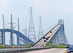
Rainbow and Veteran's Memorial bridges near river mouth
-
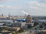
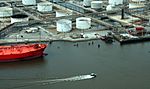
View of a portion of Port of Beaumont
-
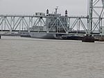
Port of Beaumont looking toward wharfs 5,6,&7
-
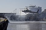
1st Air Cavalry Brigade Takes Birds to Port of Beaumont
-
River view at one of the petro-chemical facilities
-
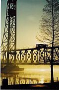
The KCS Railway bridge over the Neches River in Beaumont is a major transportation link for the region.
.jpg)


Places to See Along the Neches River
- Lake Palestine
- Neches River National Wildlife Refuge
- B. A. Steinhagen Reservoir
- Big Thicket National Preserve
- The Port of Beaumont is located on the Neches River in Beaumont, Texas. It is near the mouth of the river and the Rainbow Bridge.
See also
 In Spanish: Río Neches para niños
