
Sabine Lake facts for kids
Quick facts for kids Sabine Lake |
|
|---|---|

Satellite image of Sabine Lake, with a portion of Port Arthur visible in the upper left
|
|

Sabine Lake
Location in Louisiana

Sabine Lake
Location in Texas

Sabine Lake
Location in the United States
|
|
| Location | Texas/Louisiana Gulf Coast |
| Coordinates | 29°52′30″N 93°50′51″W / 29.87500°N 93.84750°W |
| Primary inflows | Neches River, Sabine River |
| Ocean/sea sources | Gulf of Mexico |
| Basin countries | United States |
| Max. length | 14 miles (23 km) |
| Max. width | 7 miles (11 km) |
| Surface area | 45,320 acres (18,340 ha) |
| Max. depth | 10 feet (3 m) |
| Islands | Pleasure Island |
| Settlements | Port Arthur, Texas |
Sabine Lake is a large bay located on the Gulf Coast where Texas and Louisiana meet. It's about 90 miles (145 km) east of Houston and 160 miles (257 km) west of Baton Rouge. The city of Port Arthur is right next to it.
This lake is formed where the Neches River and Sabine River flow together. It connects to the Gulf of Mexico through a narrow passage called Sabine Pass. Sabine Lake also marks part of the border between Texas and Louisiana. It touches Jefferson and Orange Counties in Texas, and Cameron Parish, Louisiana in Louisiana.
Sabine Lake is one of seven main estuaries along the Texas Gulf Coast. An estuary is where a river meets the sea, mixing fresh and salt water. Much of the Louisiana side of the lake is protected by the Sabine National Wildlife Refuge. People have lived around Sabine Lake for a very long time. Native American groups were here at least 1,500 years ago. European explorers arrived in the 1700s. Later, the city of Port Arthur grew in the 1900s. Today, the lake is an important part of the Sabine–Neches Waterway and the Gulf Intracoastal Waterway. It is a busy place for shipping and industries that make products from oil and gas.
Contents
History of Sabine Lake
People have lived near Sabine Lake for many centuries. Archaeologists have found signs that Native American groups, part of the Marksville culture, lived near the lake around the year 500 CE. Burial mounds were found near the north shore, where Port Neches is today. These might have belonged to the Karankawa people. By the 1700s, when Europeans arrived, the Atakapa people lived in the area.
European Exploration and Early Uses
English explorers, led by George Gauld, mapped Sabine Lake in 1777. Spanish explorers also visited the lake that same year. Another Spanish group mapped the lake in 1785 as they surveyed the Texas coast. In the early 1800s, the lake was used by smugglers, including the pirate Jean Lafitte. They moved goods that were not allowed into the region. The lake was also used to transport timber and cotton from inland areas to the coast.
Changing Borders and Growth
In 1801, a treaty made Sabine Lake part of the border between French Louisiana and Spanish Texas. After the Louisiana Purchase, the lake became part of the United States' border with Spanish Texas. Later, it bordered Mexican Texas and then the Republic of Texas. During the time of the Republic of Texas, there were disagreements about taxes on shipping on the lake. But when Texas joined the U.S., Sabine Lake became part of the border between the U.S. states of Louisiana and Texas.
In the mid-to-late 1800s, settlements around the lake were not permanent. A big storm, the 1886 Indianola hurricane, destroyed the main towns nearby. These were Sabine Pass and Johnson Bayou.
Developing the Waterways
To make it easier for ships to enter the lake, the inlet at Sabine Pass was dredged and made deeper in 1880. In 1895, the city of Port Arthur was founded. The southwestern part of the lake was made into a channel in 1899, creating the Port Arthur Canal. This channel connected Sabine Pass to Port Arthur.
In 1901, oil was discovered at Spindletop, which started the Texas oil boom. This led to fast economic growth in nearby Beaumont. People wanted to expand the canal system. By 1908, Sabine Lake's channel was extended north to the mouths of the Neches and Sabine Rivers. This improved shipping access to the ports of Beaumont and Orange. This combined system of channels is now known as the Sabine–Neches Waterway.
The dirt and sand removed during the channel work were used to create Pleasure Island. This is an artificial barrier island that runs along most of the western shore. It protects Port Arthur and the waterway. In 1937, most of the Louisiana shore became part of the Sabine National Wildlife Refuge. In the early 1900s, the lake and its shipping channel became part of a larger network of canals. This network stretched from New Orleans to Galveston Bay. After World War II, this network grew into the Gulf Intracoastal Waterway.
Features of Sabine Lake

Sabine Lake is located on the Gulf Coastal Plain at the Texas–Louisiana border. The natural parts of the lake are usually about 10 feet (3 meters) deep. However, the ship channels have been dug much deeper, to more than 40 feet (12 meters).
The eastern (Louisiana) shore has very little human development. Most of it is protected within the Sabine National Wildlife Refuge. The western (Texas) shore is very developed. The city of Port Arthur is there, along with many shipping and oil-related buildings.
Pleasure Island runs next to the western shore for about 18 miles (29 km). It separates the Port Arthur Canal and Sabine–Neches Canal from the main part of the lake. The Martin Luther King Bridge crosses the Sabine–Neches Canal to connect Port Arthur to Pleasure Island. The Sabine Causeway connects Pleasure Island to the Louisiana shore at the southern end of the lake. Water flows between Sabine Lake and the Gulf of Mexico at Sabine Pass.
Sabine Lake is the smallest of the seven main estuaries along the Texas Gulf Coast. It is about 14 miles (23 km) long and 7 miles (11 km) wide. Its surface area is about 45,320 acres (18,340 hectares). The Neches and Sabine Rivers flow into the lake, along with smaller streams. Because the lake is small and a lot of fresh water flows into it, it has the least salt of the major Texas estuaries.
Before the 1900s, the lake was even less salty. The upper parts were almost completely fresh. But since then, the lake has been dug out a lot for channels. This has caused more salt water to enter the estuary, especially when less fresh water flows in. This increase in saltiness has harmed the variety and growth of wetland plants in the area.
Ecosystem and Wildlife
.jpg)
The main type of water plant in Sabine Lake is Ruppia maritima, also known as widgeongrass. The lake is home to many different finfish and shellfish. Popular sport fishing species include Atlantic croaker, spotted seatrout, southern flounder, red and black drum, sheepshead, and gafftopsail catfish. Other important fish include the bay anchovy, Gulf menhaden, and spot.
Commercial fishing in the lake mainly catches shellfish. These include blue crab and different types of penaeid shrimp, like northern brown shrimp and Atlantic white shrimp. Sabine Lake is the only major Texas estuary where people do not commercially harvest American oysters. This is because the lake does not have suitable oyster beds, and the water is too polluted for legal oyster harvesting.
The land around the lake includes Western Gulf coastal grasslands and coastal marsh ecosystems. There are also urban areas in Port Arthur and its suburbs on the western shore. Most of the natural shoreline is surrounded by brackish marshes. These marshes have plants like cordgrasses and common reeds as the main types of plants.
These coastal wetlands provide homes for animals such as American alligators, Atlantic ridley sea turtles, red wolves, and brown pelicans. Since the late 1800s, human activities have caused more salt water to enter the lake and the land to sink. This has led to plants dying and the land eroding. The remaining marshes are still changing as the ecosystem adapts to the altered water flow in the estuary.
Industry and Economy
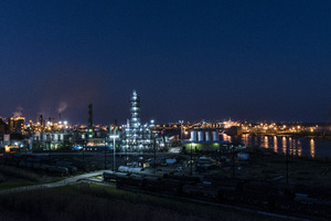
The channels dug in Sabine Lake have made it a very important waterway for industry. It is a key part of the Gulf Intracoastal Waterway and the center of the Sabine–Neches Waterway. The three ports connected to the Gulf of Mexico by the lake (Port Arthur, Beaumont, and Orange) are a major hub for shipping and the petrochemical industries. This area is often called the Golden Triangle of Texas.
The biggest industries around the lake are:
- Taking oil and natural gas out of the ground.
- Processing oil and gas into other products.
- Shipping goods by water.
- Building and repairing ships.
Farming is also an important part of the local economy. Farmers mainly grow rice and soybeans, raise livestock, and participate in commercial fishing.
- Sabine Lake from the Handbook of Texas Online
See also
 In Spanish: Lago Sabine para niños
