
Johnson Bayou, Louisiana facts for kids
Quick facts for kids
Johnson Bayou, Louisiana
|
|
|---|---|

Johnson Bayou, Louisiana
Location in Louisiana
|
|
| Country | United States |
| State | Louisiana |
| Parish | Cameron |
| Elevation | 0 ft (0 m) |
| Time zone | UTC-6 (CST) |
| • Summer (DST) | UTC-5 (CDT) |
| Area code(s) | 337 |
Johnson Bayou is a small community located in Cameron Parish, Louisiana, United States. It sits right on the Gulf Coast, along a scenic route called the Creole Nature Trail. The community is named after Daniel Johnson, who settled here around 1790.
This village is built on a special type of landform called a barrier island. These islands are made up of ridges of sand and shells, formed over time by the Mississippi River. This unique land, known as a coastal cheniere, is quite rare and found in only a few places around the world.
Before two big storms hit in 2020, about 400 people lived in Johnson Bayou. After Hurricanes Laura and Delta caused a lot of damage, the population dropped. By September 2021, it had started to recover, with almost 300 residents. Johnson Bayou is also part of the larger Lake Charles area.

Contents
History of Johnson Bayou
Johnson Bayou has faced many powerful storms throughout its history. These storms have often caused a lot of damage to the community.
The Great Storm of 1886
On October 12, 1886, a massive storm completely destroyed Johnson Bayou. A huge wall of water, called a storm surge, between seven and twelve feet high, swept inland. This terrible event caused the deaths of 50 to 100 people. The storm also badly damaged about thirty miles of railway tracks between Sabine Pass and Beaumont.
Hurricanes in Modern Times
Johnson Bayou was hit again by Hurricane Audrey in 1957. Then, on September 24, 2005, Hurricane Rita caused more damage. Two years later, on September 13, 2007, Hurricane Humberto brought heavy rains to the area.
A year after that, on September 13, 2008, Hurricane Ike made landfall nearby. This hurricane caused widespread damage across the region.
Most recently, in 2020, Johnson Bayou was struck by two major hurricanes. Hurricane Laura hit on August 27, 2020, followed by Hurricane Delta on October 6, 2020. These storms caused significant destruction to the community.
Geography of Johnson Bayou
Johnson Bayou is located at an elevation of about 5 to 7 feet (around 2 meters) above sea level. It sits on a barrier island along Louisiana Highway 82.
The community is about 12 miles (19 km) west of Holly Beach. It is also about 28 miles (45 km) southeast of Port Arthur, Texas, across the Sabine Pass channel.
Community and Nature
Johnson Bayou is home to the Holleyman Bird Sanctuary, also known as the Peveto Woods Bird & Butterfly Sanctuary. This special place is a haven for birds and butterflies. It is located south of the Sabine National Wildlife Refuge, which is a large area protected for wildlife.
The community also plays a role in energy. It has four natural gas pipelines running through it. Johnson Bayou is also the site of one of the world's largest LNG (Liquefied Natural Gas) terminals. This terminal helps process and transport natural gas.
Education in Johnson Bayou
The Cameron Parish School Board manages the schools in the area.
Johnson Bayou High School
Johnson Bayou High School is a school that serves both elementary and high school students from the community.
Cameron Parish Public Library
The Cameron Parish Public Library used to have a branch in Johnson Bayou. It was located at 4586 Gulf Beach Highway. However, the library closed for a while after Hurricane Laura in August 2020. It was expected to reopen in January 2022.
Gallery
-
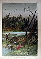
Destruction from the Great October Hurricane of 1886
-
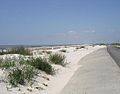
The beach between Johnson Bayou and Holly Beach prior to Hurricane Rita in 2005
-
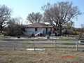
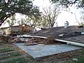
A house in Johnson Bayou destroyed by Hurricane Rita
-
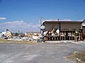
Hurricane Ike damage to main store and buildings
-

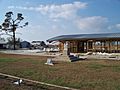
Hurricane Ike damage to school building
-

School suffered severe damage inside building due to Hurricane Ike
-
Church and buildings damaged by Hurricane Ike
-
Brick house completely destroyed with nearby double wide house severely damaged from Hurricane Ike


_School_entrance.jpg)
_School.jpg)


