
Sabine National Wildlife Refuge facts for kids
Quick facts for kids Sabine National Wildlife Refuge |
|
|---|---|
|
IUCN Category IV (Habitat/Species Management Area)
|
|
 |
|

Sabine National Wildlife Refuge
Location in the United States
|
|
| Location | Cameron Parish, Louisiana |
| Nearest city | Hackberry, Louisiana |
| Area | 124,511 acres (503.88 km2) |
| Established | 1937 |
| Visitors | open to public |
| Governing body | U.S. Fish and Wildlife Service |
| Website | Sabine National Wildlife Refuge |
The Sabine National Wildlife Refuge is a special place in southwestern Louisiana. It is a National Wildlife Refuge managed by the United States government. You can find it in Cameron Parish, along Louisiana State Route 27. The refuge is about 8 miles (13 km) south of Hackberry. It is also about 12 miles (19 km) north of Holly Beach. On its western side, the refuge touches Sabine Lake. This lake is an inlet that leads to Port Arthur, Texas. The eastern part of the refuge reaches Calcasieu Lake.
Contents
What is the Southwest Louisiana National Wildlife Refuge Complex?
The Southwest Louisiana National Wildlife Refuge Complex was created in 2004. It brought together several wildlife refuges under one management system. These refuges include the East Cove National Wildlife Refuge and Lacassine National Wildlife Refuge. It also includes the Cameron Prairie National Wildlife Refuge and Shell Keys National Wildlife Refuge. Sabine National Wildlife Refuge is also part of this important group.
Amazing Animals and Their Homes
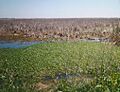
Sabine is a huge wildlife sanctuary, covering 124,511 acres (504 km²). It is the largest coastal marsh refuge along the Gulf Coast of the United States. This amazing place is home to more than 200 different species of birds.
Birds of Sabine Refuge
You can see many types of birds here, such as:
- Ducks
- Geese
- Great egrets
- Neotropic cormorants
- Raptors (like hawks and eagles)
- Snowy egrets
- Wading birds
- Shorebirds
Other Wildlife at Sabine
Besides birds, many other animals live in the refuge. You might spot a large number of American alligators. The waters are also home to blue crabs and shrimp. On land, you could see American mink and muskrats. Other animals include coypu, North American river otters, rabbits, and various turtles.
Exploring the Refuge Trails
The visitor center has information about the Wetland Walkway. This is a 1.5-mile (2.4 km) nature trail made of concrete. Part of it is a wooden boardwalk. It is located about 4 miles (6.4 km) south of the refuge headquarters. The walkway has an observation tower. There are also fifteen "knowledge stations" to teach you about the Gulf Coast marshland.
Another trail is the Blue Goose Trail. This trail is 1 mile (1.6 km) long round trip. It offers a beautiful scenic overlook.
How Hurricanes Impact Sabine Refuge

Sabine National Wildlife Refuge was directly hit by Hurricane Rita on September 24, 2005. The storm caused a lot of damage. All the main buildings, like the office and visitor center, were too damaged to fix. They had to be removed. Only three buildings at the headquarters were repaired.
Damage to Recreation Areas
Recreational spots along Highway 27 were also badly affected. Bridges, piers, observation towers, and boardwalks were damaged. Restrooms, fences, and parking lots also needed repairs. Refuge staff are working with others to fix these areas.
Marsh and Canal Damage
West of Highway 27, the refuge's canals and marshes were severely impacted. Strong winds and water from the storm caused a lot of destruction. About 32,000 acres (129.5 km²) of marshland and levees were damaged. Canals and marshes became clogged with millions of cubic meters of debris. This debris came from offshore oil rigs and nearby coastal towns.
There were also dangerous materials left behind. Tanks and barrels with liquids and gases could break open. This would release harmful substances into the environment. Over 1,400 containers of hazardous materials were found. They were estimated to hold between 115,000 and 350,000 gallons of dangerous liquids and gases.
Sabine National Wildlife Refuge Facts

Here are some quick facts about the Sabine National Wildlife Refuge:
- Location: 29°54′N 93°32′W / 29.900°N 93.533°W
- Average Elevation: 10 feet (3 meters) above sea level.
- Total Area:
- Water: 39,844 acres (161 km²)
- Grassland/Marsh: 84,667 acres (343 km²)
- Visitors: Around 300,000 people visit each year.
Images for kids
-
-
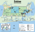
Sabine NWR map (U.S. Fish & Wildlife Service; click for a larger view).
-
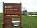
Sabine National Wildlife Refuge - Hunter Check Station
