Cameron Parish, Louisiana facts for kids
Quick facts for kids
Cameron Parish
|
|
|---|---|

|
|

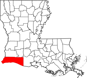
Location within the U.S. state of Louisiana
|
|
 Louisiana's location within the U.S. |
|
| Country | |
| State | |
| Founded | 1870 |
| Named for | Simon Cameron |
| Seat | Cameron |
| Largest community | Grand Lake |
| Area | |
| • Total | 1,937 sq mi (5,020 km2) |
| • Land | 1,285 sq mi (3,330 km2) |
| • Water | 652 sq mi (1,690 km2) 34% |
| Population
(2020)
|
|
| • Total | 5,617 |
| • Density | 4.37/sq mi (1.69/km2) |
| Time zone | UTC−6 (Central) |
| • Summer (DST) | UTC−5 (CDT) |
| Congressional district | 3rd |
Cameron Parish (pronounced "PAIR-ish") is a special kind of county in the southwest part of Louisiana. It's located right in the corner of the state. In 2020, about 5,617 people lived here. The main town, or "parish seat," is called Cameron.
Even though Cameron Parish is the largest parish in Louisiana by land size, it has one of the smallest populations. It's part of the larger Lake Charles area.
Contents
History of Cameron Parish
This area was once part of a huge French colony called La Louisiane. French settlers arrived here in the 1600s and early 1700s. They met Native American groups like the Atakapa and Choctaw peoples, who had lived here for thousands of years.
French and Spanish Rule
In the late 1700s, after France lost a big war, many French-speaking families moved here. These families were called Acadians. They came from a place called Acadia (now part of Canada) and were forced to leave by the British. Many of their descendants still live in the small towns of Cameron Parish today.
Later, France gave this land to Spain. The Spanish government even gave land to the Acadians. But then, around 1800, France took control of the area again for a short time under Napoleon Bonaparte.
Louisiana Purchase and Early American Settlers
In 1803, Napoleon sold all of France's land west of the Mississippi River to the United States. This huge deal was called the Louisiana Purchase. The U.S. especially wanted New Orleans, a very important port city.
After the Louisiana Purchase, some early American settlers moved into this area. In 1807, this land became part of Calcasieu Parish. The western part of this coastal area was once called "No Man's Land." This was a disputed area between Spain and the U.S. for many years. It was known for outlaws and pirates, like Jean Lafitte. The U.S. finally gained full control of this land in 1819.
American Civil War and Jayhawkers
During the American Civil War, people in this area had mixed loyalties. Some supported the Union (the North), and others supported the Confederacy (the South). Groups called "Jayhawkers" were active here. They were made up of people who didn't want to fight in the war, runaway slaves, and even thieves. They caused trouble for both sides and for local families.
Local groups called "Regulators" tried to protect their communities from the Jayhawkers. After the war, some of these Regulators caused problems for Black people and tried to stop new laws meant to help them.
Founding of Cameron Parish
Cameron Parish was officially created in 1870. It was formed from parts of Calcasieu and Vermilion parishes. The parish was named after Simon Cameron, a politician from Pennsylvania. He was President Abraham Lincoln's first Secretary of War.
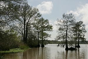
Cameron Parish is one of the largest parishes in Louisiana. However, it has very few people because much of its land is marsh and wetlands. The area is known for its "cheniers," which are raised, fertile ridges found along the coast. These ridges were used for farming and raising animals in the past.
20th Century Changes
In 1937, oil was discovered offshore near Cameron Parish. This was the first offshore oil field in Louisiana! Over time, some wetlands were drained and waterways were dug deeper for ships. While this helped with oil production, it also caused the coastline to wear away faster.
From the mid-1900s to the early 2000s, Cameron Parish was hit hard by four major hurricanes: Audrey, Rita, Ike, and Laura.
Hurricane Audrey struck on June 27, 1957. It was a terrible storm that caused over 390 deaths. People in Cameron Parish often talk about history as "before Audrey" and "after Audrey."
21st Century Hurricanes
On September 24, 2005, Hurricane Rita destroyed much of the parish. A movie called Little Chenier was filmed there just before Rita hit. It shows what the area looked like before the storm.
In 2008, Hurricane Ike brought a huge storm surge that flooded the coastline. Many communities like Cameron, Holly Beach, and Creole were almost completely destroyed. Because of these two hurricanes, the population of the parish dropped by almost one-third between 2000 and 2010.
In 2020, Hurricane Laura hit near Cameron with very strong winds. Just six weeks later, Hurricane Delta also made landfall in the area.
Today, Cameron Parish is a popular place for hunting and fishing.
Geography
Cameron Parish covers a total area of about 1,937 square miles. About 1,285 square miles is land, and 652 square miles (34%) is water. Much of this water is part of the marshlands along the Gulf of Mexico. It is the third-largest parish in Louisiana by land area.
Main Roads
Neighboring Areas
Cameron Parish shares borders with these other parishes and counties:
- Calcasieu Parish (to the northwest)
- Jefferson Davis Parish (to the northeast)
- Vermilion Parish (to the east)
- Jefferson County, Texas (to the southwest)
- Orange County, Texas (to the west)
Protected Natural Areas
Cameron Parish is home to several important wildlife refuges:
- Cameron Prairie National Wildlife Refuge
- East Cove National Wildlife Refuge
- Lacassine National Wildlife Refuge (part of it)
- Sabine National Wildlife Refuge
Communities
Cameron Parish does not have any official cities or towns. Instead, it has several communities.
Census-Designated Places
These are areas that the U.S. Census Bureau defines for gathering population data:
Other Communities
These are smaller, unincorporated communities:
- Constance Beach
- Creole
- Gibbstown
- Grand Chenier
- Grand Lake
- Hacketts Corner
- Holly Beach
- Johnson Bayou
- Lone Pine
- Lowry
- Rutherford Beach
Population Facts
| Historical population | |||
|---|---|---|---|
| Census | Pop. | %± | |
| 1870 | 1,591 | — | |
| 1880 | 2,416 | 51.9% | |
| 1890 | 2,828 | 17.1% | |
| 1900 | 3,952 | 39.7% | |
| 1910 | 4,288 | 8.5% | |
| 1920 | 3,952 | −7.8% | |
| 1930 | 6,054 | 53.2% | |
| 1940 | 7,203 | 19.0% | |
| 1950 | 6,244 | −13.3% | |
| 1960 | 6,909 | 10.7% | |
| 1970 | 8,194 | 18.6% | |
| 1980 | 9,336 | 13.9% | |
| 1990 | 9,260 | −0.8% | |
| 2000 | 9,991 | 7.9% | |
| 2010 | 6,839 | −31.5% | |
| 2020 | 5,617 | −17.9% | |
| U.S. Decennial Census 1790-1960 1900-1990 1990-2000 2010-2013 |
|||
The number of people living in Cameron Parish dropped a lot between 2000 and 2010. This was mainly because of the damage from Hurricanes Rita and Ike in 2005 and 2008.
| Race | Num. | Perc. |
|---|---|---|
| White (non-Hispanic) | 5,174 | 92.11% |
| Black or African American (non-Hispanic) | 71 | 1.26% |
| Native American | 28 | 0.5% |
| Asian | 13 | 0.23% |
| Pacific Islander | 1 | 0.02% |
| Other/Mixed | 133 | 2.37% |
| Hispanic or Latino | 197 | 3.51% |
In 2020, there were 5,617 people living in Cameron Parish. Most people (about 92%) were White. A smaller number of people were Black or African American, Native American, Asian, or other races. About 3.5% of the population was Hispanic or Latino.
In 2010, most people in the parish (about 95.7%) were White. Many people in Cameron Parish have French, French Canadian, or Cajun family backgrounds.
Education
The Cameron Parish School Board runs the public schools in Cameron Parish.
Students in Cameron Parish can also attend Sowela Technical Community College.
The Cameron Parish Public Library system serves the area. All of its libraries are in smaller communities, not in official cities.
The main library is at 512 Marshall Street in Cameron.
There are also six branch libraries:
- Grand Chenier Branch at 2863 Grand Chenier Highway
- Grand Lake Branch at 10200 Gulf Hwy
- Hackberry Branch at 613 Main Street
- Johnson Bayou Branch at 4586 Gulf Beach Highway
- Lowry Branch at 454 Lowry Highway
Notable People
- Gilbert Franklin Hennigan: He represented Cameron Parish in the Louisiana State Senate from 1944 to 1956.
- Doug Kershaw: A famous musician, he was born in Cameron Parish on January 24, 1936.
- Conway LeBleu: Born in Lake Charles, he represented both Calcasieu and Cameron parishes in the Louisiana House from 1964 to 1988.
See also
 In Spanish: Parroquia de Cameron para niños
 | Delilah Pierce |
 | Gordon Parks |
 | Augusta Savage |
 | Charles Ethan Porter |

