Jefferson County, Texas facts for kids
Quick facts for kids
Jefferson County
|
||
|---|---|---|

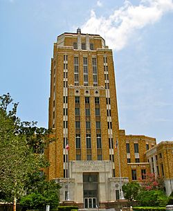
The Jefferson County Courthouse in Beaumont. The Art Deco-style building was added to the National Register of Historic Places on June 17, 1982. The top five floors once served as the County Jail.
|
||
|
||

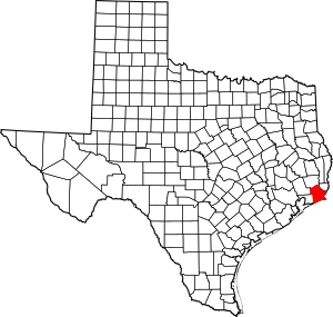
Location within the U.S. state of Texas
|
||
 Texas's location within the U.S. |
||
| Country | ||
| State | ||
| Founded | 1837 | |
| Named for | Thomas Jefferson | |
| Seat | Beaumont | |
| Largest city | Beaumont | |
| Area | ||
| • Total | 1,113 sq mi (2,880 km2) | |
| • Land | 876 sq mi (2,270 km2) | |
| • Water | 236 sq mi (610 km2) 21%% | |
| Population
(2020)
|
||
| • Total | 256,526 |
|
| Time zone | UTC−6 (Central) | |
| • Summer (DST) | UTC−5 (CDT) | |
| Congressional districts | 14th, 36th | |
Jefferson County is a county located in the southeastern part of Texas. It's known for its coastal plains and is right next to the Gulf of Mexico. The Neches River forms its northeastern border.
As of the 2020 census, about 256,526 people live here. The main city and county seat is Beaumont. Jefferson County has the highest percentage of African Americans in Texas.
The area became a county in 1837, after Texas became independent. It was named after Thomas Jefferson, a former U.S. president. Before that, it was part of Mexico.
Jefferson County is a big part of the Beaumont–Port Arthur metropolitan area. This area includes four counties, and Jefferson County has the most people. It also has several correctional facilities.
Contents
Exploring Jefferson County's Land
What is Jefferson County's size?
Jefferson County covers a total area of about 1,113 square miles. Most of this is land (876 square miles), and about 236 square miles (21%) is water.
The county is located on the flat lands of the Texas Gulf Coast. To the north, it's bordered by Pine Island Bayou. The Neches River is to its northeast. To the east, you'll find Sabine Lake and the mouth of the Sabine River.
The southern part of the county has a lot of marshland. Much of this marsh is part of Sea Rim State Park. This park stretches all the way to the beach along the Gulf of Mexico.
Main Roads in Jefferson County
 Interstate 10

 U.S. Highway 69/U.S. Highway 96/U.S. Highway 287
 U.S. Highway 90
 State Highway 73
 State Highway 82
 State Highway 87
 State Highway 105
 State Highway 124
 State Highway 326
 State Highway 347
Neighboring Counties and Parishes
- Hardin County (north)
- Orange County (northeast)
- Chambers County (southwest)
- Liberty County (northwest)
- Cameron Parish, Louisiana (east)
Protected Natural Areas
- Big Thicket National Preserve (part)
- McFaddin National Wildlife Refuge
- Texas Point National Wildlife Refuge
Communities in Jefferson County
Cities to Know
- Beaumont (This is the county seat and the biggest city!)
- Bevil Oaks
- China
- Groves
- Nederland
- Nome
- Port Arthur
- Port Neches
- Taylor Landing
Other Areas to Explore
Census-Designated Places
These are areas that are like towns but aren't officially incorporated as cities.
Other Communities
Who Lives in Jefferson County?
| Historical population | |||
|---|---|---|---|
| Census | Pop. | %± | |
| 1850 | 1,836 | — | |
| 1860 | 1,995 | 8.7% | |
| 1870 | 1,906 | −4.5% | |
| 1880 | 3,489 | 83.1% | |
| 1890 | 5,857 | 67.9% | |
| 1900 | 14,239 | 143.1% | |
| 1910 | 38,182 | 168.2% | |
| 1920 | 73,120 | 91.5% | |
| 1930 | 133,391 | 82.4% | |
| 1940 | 145,329 | 8.9% | |
| 1950 | 195,083 | 34.2% | |
| 1960 | 245,659 | 25.9% | |
| 1970 | 244,773 | −0.4% | |
| 1980 | 250,938 | 2.5% | |
| 1990 | 239,397 | −4.6% | |
| 2000 | 252,051 | 5.3% | |
| 2010 | 252,273 | 0.1% | |
| 2020 | 256,526 | 1.7% | |
| U.S. Decennial Census 1850–2010 2010–2020 |
|||
In 2020, Jefferson County had a population of 256,526 people. The population has grown steadily over the years.
In 2000, there were 252,051 people living in the county. About 33% of households had children under 18. The average household had about 2.55 people.
The median age in the county was 35 years old. This means half the people were younger than 35 and half were older. For every 100 females, there were about 101 males.
The median income for a household in 2000 was $34,706. This means half of the households earned more than this amount, and half earned less. About 17.4% of the population lived below the poverty line.
How Jefferson County Makes Money
What drives the local economy?
Jefferson County's economy is very strong, especially because of its deep-water ports. These ports are in cities like Beaumont and Port Arthur. The Sabine Neches Waterway helps big ships reach these ports. This waterway is one of the busiest ports in the U.S.
The county also has good transportation links. Interstate 10, along with other U.S. and State Highways, runs through the area. There are also train and truck services for moving goods. The Jack Brooks Regional Airport handles both passengers and cargo.
The main industries here are:
- Refining petroleum (oil)
- Making and processing petrochemicals (chemicals from oil and gas)
- Producing bio-fuels and other chemicals
- Making steel products
- Shipping goods
- Manufacturing wood, pulp, and food products
- Agriculture (farming)
- Health care services
The county is also working to add more types of jobs, especially in services and government. It's even home to the largest military off-load port in the world!
Many large projects are happening in the area. Companies like Exxon Mobil and Golden Pass LNG are investing a lot. This shows how important the county is for energy and trade. The county is also working to make sure there are enough skilled workers for these growing industries.
Learning in Jefferson County
Schools and Colleges
Jefferson County has several school districts:
- Beaumont Independent School District
- Hamshire-Fannett Independent School District
- Hardin-Jefferson Independent School District
- Nederland Independent School District
- Port Arthur Independent School District
- Port Neches–Groves Independent School District
- Sabine Pass Independent School District
For higher education, Beaumont is home to Lamar University. This is a public research university. In Fall 2014, it had almost 15,000 students. It offers many different degree programs, from bachelor's to doctoral degrees.
Port Arthur has Lamar State College–Port Arthur. This college offers two-year degrees and one-year certifications. It helps students get ready for specific jobs. In Fall 2014, it had over 2,000 students.
See also
 In Spanish: Condado de Jefferson (Texas) para niños
 | Jessica Watkins |
 | Robert Henry Lawrence Jr. |
 | Mae Jemison |
 | Sian Proctor |
 | Guion Bluford |


