Liberty County, Texas facts for kids
Quick facts for kids
Liberty County
|
|
|---|---|

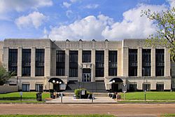
The Liberty County Courthouse in Liberty
|
|

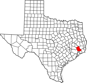
Location within the U.S. state of Texas
|
|
 Texas's location within the U.S. |
|
| Country | |
| State | |
| Founded | 1836 |
| Named for | Liberty |
| Seat | Liberty |
| Largest city | Dayton |
| Area | |
| • Total | 1,176 sq mi (3,050 km2) |
| • Land | 1,158 sq mi (3,000 km2) |
| • Water | 18 sq mi (50 km2) 1.5% |
| Population
(2020)
|
|
| • Total | 91,628 |
| • Density | 77.91/sq mi (30.083/km2) |
| Time zone | UTC−6 (Central) |
| • Summer (DST) | UTC−5 (CDT) |
| Congressional district | 36th |
Liberty County is a county in the state of Texas, USA. Think of a county as a local area within a state. In 2020, about 91,628 people lived here. The main town, or county seat, is Liberty.
The county was first set up in 1831 when Texas was part of Mexico. It was called Villa de la Santísima Trinidad de la Libertad. Later, in 1836, when Texas became its own country, it was renamed Liberty County. The name "Liberty" was chosen to represent the idea of freedom.
Liberty County is also part of the larger Houston–The Woodlands–Sugar Land area.
Contents
Geography
Liberty County covers a total area of about 1,176 square miles. A small part, about 18 square miles, is covered by water.
The Trinity River flows right through the middle of the county. It even forms part of the border with other counties. The east fork of the San Jacinto River also flows through the northeast part of the county, near Cleveland. Another waterway, Tarkington Bayou, starts in a national forest and flows south through the county.
The highest point in Liberty County is called "Davis Hill." It's actually the top of a salt dome in the northern part of the county.
Neighboring Counties
Liberty County shares borders with these other counties:
- Polk County (north)
- Hardin County (east)
- Jefferson County (southeast)
- Chambers County (south)
- Harris County (southwest)
- Montgomery County (west)
- San Jacinto County (northwest)
Protected Natural Areas
Parts of these special natural areas are found in Liberty County:
Communities
Liberty County has several towns and cities where people live.
Cities
- Ames
- Cleveland
- Daisetta
- Dayton
- Dayton Lakes
- Devers
- Hardin
- Liberty (the county seat)
- Mont Belvieu (mostly in Chambers County)
- Nome
- North Cleveland
- Old River-Winfree (mostly in Chambers County)
- Plum Grove
Town
Census-Designated Place
- Big Thicket Lake Estates (partly in Polk County)
- Hull
Unincorporated Communities
These are smaller communities not officially part of a city or town.
Population Information
The population of Liberty County has grown a lot over the years. In 1850, there were only 2,522 people. By 2020, the population had reached 91,628.
| Historical population | |||
|---|---|---|---|
| Census | Pop. | %± | |
| 1850 | 2,522 | — | |
| 1860 | 3,189 | 26.4% | |
| 1870 | 4,414 | 38.4% | |
| 1880 | 4,999 | 13.3% | |
| 1890 | 4,230 | −15.4% | |
| 1900 | 8,102 | 91.5% | |
| 1910 | 10,686 | 31.9% | |
| 1920 | 14,637 | 37.0% | |
| 1930 | 19,868 | 35.7% | |
| 1940 | 24,541 | 23.5% | |
| 1950 | 26,729 | 8.9% | |
| 1960 | 31,595 | 18.2% | |
| 1970 | 33,014 | 4.5% | |
| 1980 | 47,088 | 42.6% | |
| 1990 | 52,726 | 12.0% | |
| 2000 | 70,154 | 33.1% | |
| 2010 | 75,643 | 7.8% | |
| 2020 | 91,628 | 21.1% | |
| 2023 (est.) | 108,272 | 43.1% | |
| U.S. Decennial Census 1850–2010 2010 2020 |
|||
The county is also becoming more diverse. The table below shows how the different racial and ethnic groups have changed over time.
| Race / Ethnicity (NH = Non-Hispanic) | Pop 2000 | Pop 2010 | Pop 2020 | % 2000 | % 2010 | % 2020 |
|---|---|---|---|---|---|---|
| White alone (NH) | 52,289 | 52,321 | 50,044 | 74.53% | 69.17% | 54.62% |
| Black or African American alone (NH) | 8,952 | 8,074 | 7,024 | 12.76% | 10.67% | 7.67% |
| Native American or Alaska Native alone (NH) | 284 | 289 | 291 | 0.40% | 0.38% | 0.32% |
| Asian alone (NH) | 218 | 337 | 466 | 0.31% | 0.45% | 0.51% |
| Pacific Islander alone (NH) | 18 | 23 | 12 | 0.03% | 0.03% | 0.01% |
| Other race alone (NH) | 69 | 120 | 329 | 0.10% | 0.16% | 0.36% |
| Mixed race or Multiracial (NH) | 664 | 877 | 2,665 | 0.95% | 1.16% | 2.91% |
| Hispanic or Latino (any race) | 7,660 | 13,602 | 30,797 | 10.92% | 17.98% | 33.61% |
| Total | 70,154 | 75,643 | 91,628 | 100.00% | 100.00% | 100.00% |
In 2000, the county had about 70,154 people. The population density was about 60 people per square mile. The largest group was White, followed by African American and Hispanic or Latino.
Liberty County has a lower percentage of residents with a college degree compared to other counties of its size.
Economy
Around 1995, Liberty County's economy mainly relied on farming and oil. At that time, the economy was facing challenges.
To help the economy, the Texas Department of Criminal Justice built four correctional facilities in the county. These facilities created many jobs. In 1995, they employed over 1,000 people and added $22 million to the county's yearly payroll. One of these facilities, Cleveland, is run by a private company, which means the county gets tax money from its operations.
Education
Students in Liberty County attend schools in several different school districts:
- Cleveland ISD
- Dayton Independent School District (ISD)
- Devers ISD
- Hardin ISD
- Hull-Daisetta ISD
- Liberty ISD
- Tarkington ISD
After high school, students in some districts can attend Lee College. Students in other districts can go to Lone Star College.
The Sam Houston Regional Library and Research Center is located near Liberty. It's a special library and research center. Land for the library was donated in 1973, and it opened its doors in 1977.
Infrastructure
Liberty County has services to help its residents.
Police Services
The Liberty County Sheriff's Office helps keep the peace in areas outside of cities. They also help city police departments. Most cities in the county, like Cleveland and Dayton, have their own police departments. The county also has constables and deputies in different areas.
Fire Services
Fire protection is mostly provided by volunteer fire departments. The cities of Cleveland and Liberty have their own fire departments with both paid and volunteer firefighters. These departments also cover areas outside their city limits.
Here are some of the fire departments serving the county:
- Ames VFD
- Cleveland VFD
- Cypress Lakes VFD
- Dayton VFD
- Devers VFD
- Hardin VFD
- Highway 321 VFD
- Hull-Daisetta VFD
- Kenefick VFD
- Liberty VFD
- Moss Bluff VFD
- North Liberty County VFD
- Plum Grove VFD
- Raywood VFD
- Tarkington VFD
- Westlake VFD
- Woodpecker VFD
Emergency Medical Services
Allegiance EMS provides ambulance services throughout most of the county. However, the City of Liberty Fire and EMS Department handles emergency medical services within the city of Liberty itself.
Correctional Facilities
The Texas Department of Criminal Justice operates several facilities in Liberty County. These include one women's prison, the L.V. Hightower Unit, and two women's state jails, the Dempsie Henley Unit and Lucille G. Plane Unit. These are all located north of Dayton.
There is also a men's prison called the Cleveland Unit in Cleveland. This prison is run by a private company called the GEO Group, Inc..
These facilities opened between 1989 and 1995. In 1995, Liberty County had the fourth-highest number of state prisons and jails in Texas.
Transportation
Getting around Liberty County is possible through various roads and airports.
Main Roads
 U.S. Highway 59
 U.S. Highway 90
 State Highway 61
 State Highway 99 (Grand Parkway)
 State Highway 105
 State Highway 146
 State Highway 321
Airports
There are two airports for smaller planes in the county:
- Liberty Municipal Airport is east of Liberty.
- Cleveland Municipal Airport is east of Cleveland.
For international flights, residents can use George Bush Intercontinental Airport in Houston.
Toll Roads
| Authority overview | |
|---|---|
| Formed | July 2007 |
| Jurisdiction | Liberty County, Texas |
| Headquarters | Liberty County Commissioners Court |
The Liberty County Toll Road Authority was created in 2007. Its purpose is to have a say in any new toll road projects in the county. Currently, it does not operate any toll roads.
Notable People
Some well-known people have connections to Liberty County:
- William Fields (1810-1858), an American politician.
- Edward Bradford Pickett (1823–1882), who led the Texas Constitutional Convention in 1875 and was a state lawmaker.
- Bobby Seale, a co-founder of the Black Panther Party.
See also
 In Spanish: Condado de Liberty (Texas) para niños
 | Charles R. Drew |
 | Benjamin Banneker |
 | Jane C. Wright |
 | Roger Arliner Young |

