Montgomery County, Texas facts for kids
Quick facts for kids
Montgomery County
|
|
|---|---|

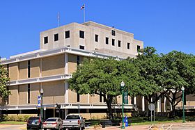
The Montgomery County Courthouse in Conroe
|
|

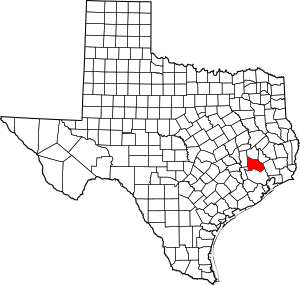
Location within the U.S. state of Texas
|
|
 Texas's location within the U.S. |
|
| Country | |
| State | |
| Founded | 1837 |
| Named for | Montgomery, Texas |
| Seat | Conroe |
| Largest community | The Woodlands |
| Area | |
| • Total | 1,077 sq mi (2,790 km2) |
| • Land | 1,042 sq mi (2,700 km2) |
| • Water | 35 sq mi (90 km2) 3.3% |
| Population
(2020)
|
|
| • Total | 620,443 |
| • Estimate
(2023)
|
711,354 |
| • Density | 576.08/sq mi (222.43/km2) |
| Time zone | UTC−6 (Central) |
| • Summer (DST) | UTC−5 (CDT) |
| Congressional districts | 2nd, 8th |
Montgomery County is a place in Texas, a state in the USA. In 2020, about 620,443 people lived here. Its main city, where the county government is, is Conroe.
The county was created on December 14, 1837. It got its name from the town of Montgomery. The county has grown a lot! Between 2000 and 2010, its population grew by 55%. From 2010 to 2020, it grew by another 36%. By July 1, 2023, the population was estimated to be 711,354 people.
Montgomery County is part of the larger Houston–The Woodlands–Sugar Land area. This is a big group of cities and towns that are connected.
Contents
Exploring Montgomery County's Geography
Montgomery County covers a total area of about 1,077 square miles. Most of this area, about 1,042 square miles, is land. The rest, about 35 square miles, is covered by water. This means about 3.3% of the county is water.
Neighboring Counties Around Montgomery
Montgomery County shares its borders with several other counties. These are like its neighbors on a map.
- Walker County (to the north)
- San Jacinto County (to the northeast)
- Liberty County (to the east)
- Harris County (to the south)
- Waller County (to the west)
- Grimes County (to the northwest)
Protected Natural Areas
Part of the Sam Houston National Forest is located in Montgomery County. This is a special area of nature that is protected.
Communities: Cities, Towns, and More
Montgomery County has many different types of communities. These include cities, towns, and other smaller places where people live.
Cities in Montgomery County
- Cleveland (mostly in Liberty County)
- Conroe (this is the county seat)
- Cut and Shoot
- Houston (mostly in Harris County)
- Magnolia
- Montgomery
- Oak Ridge North
- Panorama Village
- Patton Village
- Roman Forest
- Shenandoah
- Splendora
- Willis
- Woodbranch
Towns in Montgomery County
Census-Designated Places (CDPs)
These are areas that are like towns but are not officially incorporated as cities.
- Pinehurst
- Porter Heights
- The Woodlands (a small part is in Harris County)
Unincorporated Communities
These are smaller communities that are not part of any city or town.
- Chateau Woods (used to be a city)
- Decker Prairie
- Dobbin
- Egypt
- Grangerland
- Imperial Oaks
- New Caney
- Porter
- River Plantation
- Spring (most of it is in Harris County)
- Tamina
Understanding Montgomery County's Population
The number of people living in Montgomery County has changed a lot over the years. You can see this growth in the table below.
| Historical population | |||
|---|---|---|---|
| Census | Pop. | %± | |
| 1850 | 2,384 | — | |
| 1860 | 5,479 | 129.8% | |
| 1870 | 6,483 | 18.3% | |
| 1880 | 10,154 | 56.6% | |
| 1890 | 11,765 | 15.9% | |
| 1900 | 17,067 | 45.1% | |
| 1910 | 15,679 | −8.1% | |
| 1920 | 17,334 | 10.6% | |
| 1930 | 14,588 | −15.8% | |
| 1940 | 23,055 | 58.0% | |
| 1950 | 24,504 | 6.3% | |
| 1960 | 26,839 | 9.5% | |
| 1970 | 49,479 | 84.4% | |
| 1980 | 128,487 | 159.7% | |
| 1990 | 182,201 | 41.8% | |
| 2000 | 293,768 | 61.2% | |
| 2010 | 455,746 | 55.1% | |
| 2020 | 620,460 | 36.1% | |
| 2023 (est.) | 711,354 | 56.1% | |
| U.S. Decennial Census 1850–2010 2010–2020 |
|||
In 2010, there were about 455,746 people living in the county. There were also about 162,530 households, which are groups of people living together. The population density was about 423 people per square mile.
The county's population is made up of people from many different backgrounds. In 2010, most people were White (83.5%). There were also Black or African American (4.3%), Native American (0.7%), and Asian (2.1%) people. About 20.8% of the population was Hispanic or Latino.
By 2020, the population had grown to 620,443. The mix of people also changed. About 59.86% were non-Hispanic White. African American or Black people made up 5.51%. Hispanic or Latino people made up a larger part, at 26.45%.
In 2010, about 27.6% of the people were under 18 years old. The average age was 36.1 years. Most households were married couples living together.
Education: Schools and Colleges
Montgomery County offers many choices for education, from public schools to colleges.
Public Schools in the County
Several public school districts serve the students in Montgomery County. These districts manage the public schools.
- Conroe ISD
- Magnolia ISD
- Montgomery ISD
- New Caney ISD
- Richards ISD (partially)
- Splendora ISD
- Tomball ISD (partially)
- Willis ISD
- Humble ISD (partially)
- Cleveland ISD (partially)
Private Schools in the County
There are also many private schools for students of all ages.
- Pre-K to 12th Grade
- Covenant Christian School
- Christ Community School
- Esprit International School
- The Woodlands Christian Academy
- The John Cooper School
- The Woodlands Preparatory School
- Porter Christian Academy
- Cunae International School
- Legacy Preparatory Christian Academy
- Willis Classical Academy
- Pre-K to 8th Grade
- St. Anthony Of Padua Catholic School
The closest Catholic high school for students in The Woodlands area is Frassati Catholic High School.
Colleges and Universities
For higher education, Montgomery County has two campuses of the Lone Star College System. These are Montgomery and The University Center.
Lone Star College serves students from many local school districts. These include Conroe, Magnolia, Montgomery, New Caney, Splendora, Tomball, and Willis ISDs. Students from the Richards ISD part of the county go to Blinn Junior College District.
In the past, there were colleges for Black students before schools were desegregated. These included Conroe Normal and Industrial College and Royal College.
Libraries: Places to Read and Learn
The county has its own library system called the Montgomery County Memorial Library System. These libraries offer books, computers, and other resources for everyone.
Healthcare: Hospitals and Care
In 1938, the Montgomery County Hospital opened. It was the first public hospital in the county and had 25 beds. Later, in the 1970s, the Montgomery County Hospital District was created. This led to a new, larger hospital opening in 1982, replacing the older one.
Transportation: Getting Around the County
Montgomery County has different ways to travel, including airports and major roads.
Airports in the County
Conroe-North Houston Regional Airport is in Conroe. It's an airport for general aviation, meaning it's used for private planes and smaller flights.
The Houston Airport System says that George Bush Intercontinental Airport is the main airport for Montgomery County. This is a large international airport located in nearby Harris County.
Major Highways Connecting the County
Several important highways run through Montgomery County. They help people travel to and from different places.
 Interstate 45
 Interstate 69/U.S. Highway 59
 State Highway 75
 State Highway 99 - Grand Parkway Toll Road
 State Highway 105
 State Highway 242
 State Highway 249 - also known as MCTRA 249 Tollway and the Aggie Expressway
Toll Roads in Montgomery County
Montgomery County has some roads where you pay a fee to drive. These are called toll roads. Many of them are "pass-through" or "shadow" toll roads. This means the county gets money from the state for traffic on these roads.
There are two main toll roads in the county where you pay directly. One is a part of State Highway 249. This section is called the MCTRA 249 Tollway. It runs from the Harris County line to Pinehurst. North of Pinehurst, it continues as the Aggie Expressway (SH 249 Toll).
The other main toll road is Grand Parkway (State Highway 99). It also starts at the Harris County line and goes through Montgomery County. It then goes back into Harris County before continuing into Liberty and Chambers Counties.
See also
 In Spanish: Condado de Montgomery (Texas) para niños
 | Emma Amos |
 | Edward Mitchell Bannister |
 | Larry D. Alexander |
 | Ernie Barnes |

