San Jacinto County, Texas facts for kids
Quick facts for kids
San Jacinto County
|
|
|---|---|

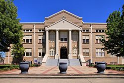
The San Jacinto County Courthouse in Coldspring
|
|

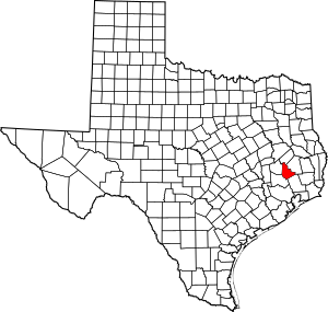
Location within the U.S. state of Texas
|
|
 Texas's location within the U.S. |
|
| Country | |
| State | |
| Founded | 1870 |
| Named for | Battle of San Jacinto |
| Seat | Coldspring |
| Largest city | Shepherd |
| Area | |
| • Total | 628 sq mi (1,630 km2) |
| • Land | 569 sq mi (1,470 km2) |
| • Water | 59 sq mi (150 km2) 9.3% |
| Population
(2020)
|
|
| • Total | 27,402 |
| • Density | 43.63/sq mi (16.847/km2) |
| Time zone | UTC−6 (Central) |
| • Summer (DST) | UTC−5 (CDT) |
| Congressional district | 8th |
San Jacinto County (pronounced SAN juh-SIN-toh) is a county located in the state of Texas in the United States. In 2020, about 27,402 people lived there. The main town, or county seat, is Coldspring.
The county got its name from the famous Battle of San Jacinto. This battle was a very important event in 1836. It helped Texas win its freedom from Mexico and become its own republic.
Contents
Exploring San Jacinto County's Geography
San Jacinto County covers a total area of about 628 square miles. Most of this area, about 569 square miles, is land. The rest, about 59 square miles, is covered by water, like lakes and rivers.
Main Roads in the County
Several important highways run through San Jacinto County, helping people travel around.
Neighboring Counties
San Jacinto County shares its borders with several other counties:
- To the north: Trinity County
- To the east: Polk County
- To the southeast: Liberty County
- To the southwest: Montgomery County
- To the west: Walker County
Protected Natural Areas
Part of the Sam Houston National Forest is located within San Jacinto County. This forest is a special protected area where nature can thrive.
Understanding the Population of San Jacinto County
The number of people living in San Jacinto County has changed over the years. Here's how the population has grown:
| Historical population | |||
|---|---|---|---|
| Census | Pop. | %± | |
| 1880 | 6,186 | — | |
| 1890 | 7,360 | 19.0% | |
| 1900 | 10,277 | 39.6% | |
| 1910 | 9,542 | −7.2% | |
| 1920 | 9,867 | 3.4% | |
| 1930 | 9,711 | −1.6% | |
| 1940 | 9,056 | −6.7% | |
| 1950 | 7,172 | −20.8% | |
| 1960 | 6,153 | −14.2% | |
| 1970 | 6,702 | 8.9% | |
| 1980 | 11,434 | 70.6% | |
| 1990 | 16,372 | 43.2% | |
| 2000 | 22,246 | 35.9% | |
| 2010 | 26,384 | 18.6% | |
| 2020 | 27,402 | 3.9% | |
| U.S. Decennial Census 1850–2010 2010 2020 |
|||
In 2000, there were 22,246 people living in the county. The population density was about 39 people for every square mile. There were also many homes, with about 11,520 housing units.
About 30% of the homes had children under 18 living there. Many homes were made up of married couples. The average age of people in the county was 40 years old. About 25% of the population was under 18, and about 16% was 65 or older.
Education in San Jacinto County
Students in San Jacinto County attend schools in several different school districts:
- Coldspring-Oakhurst Consolidated Independent School District
- Shepherd Independent School District
- Cleveland Independent School District (part of the county)
- Willis Independent School District (part of the county)
For college, students in the Coldspring-Oakhurst and Shepherd school districts can go to Angelina College. Students in the Cleveland and Willis school districts can attend Lone Star College.
Towns and Communities
San Jacinto County has several towns and communities:
Cities
- Coldspring (This is the county seat, where the main government offices are.)
- Point Blank
- Shepherd
Special Designated Places
These are areas that are like towns but are not officially incorporated as cities:
See also
 In Spanish: Condado de San Jacinto para niños
 | Kyle Baker |
 | Joseph Yoakum |
 | Laura Wheeler Waring |
 | Henry Ossawa Tanner |


