
Cameron, Louisiana facts for kids
Quick facts for kids
Cameron, Louisiana
|
|
|---|---|
 |
|

Cameron, Louisiana
Location in Louisiana

Cameron, Louisiana
Location in the United States
|
|
| Country | United States |
| State | Louisiana |
| Parish | Cameron |
| Area | |
| • Total | 12.60 sq mi (32.64 km2) |
| • Land | 11.43 sq mi (29.60 km2) |
| • Water | 1.17 sq mi (3.04 km2) |
| Elevation | 3 ft (0.9 m) |
| Population
(2020)
|
|
| • Total | 315 |
| • Density | 27.57/sq mi (10.64/km2) |
| Time zone | UTC-6 (CST) |
| • Summer (DST) | UTC-5 (CDT) |
| Zip code |
70631
|
| Area code(s) | 337 |
| FIPS code | 22-12000 |
Cameron is a small community in Cameron Parish, Louisiana, United States. It's known as a census-designated place (CDP), which means it's a specific area counted by the census. Cameron is also the main town, or parish seat, of Cameron Parish.
This coastal town has faced many challenges, especially from powerful hurricanes. After severe damage from Hurricane Rita in 2005 and Hurricane Ike in 2008, the population dropped a lot. In 2010, only 406 people lived there, a big decrease from earlier years.
Contents
History of Cameron

Cameron was first called Leesburg, but its post office was named Cameron, like the parish. Its location at the mouth of the Calcasieu River made it an important place for moving mail, cattle, and other goods by ship to Lake Charles. When the first successful oil well in Louisiana was found in 1901, Cameron became a center for getting oil out of the ground.
Major Hurricanes and Rebuilding
Cameron has been hit by several strong hurricanes over the years.
- Hurricane Audrey (1957): In 1957, Hurricane Audrey almost completely destroyed Cameron. A huge storm surge of 12 feet (3.7 meters) and winds of 125 miles per hour (201 km/h) caused a lot of damage. More than 300 people in the town sadly lost their lives.
- Hurricane Rita (2005): Nearly 50 years later, in September 2005, Hurricane Rita struck Cameron. It brought winds of 120 miles per hour (193 km/h) and some of the highest storm surges ever recorded in Louisiana, reaching up to 17.8 feet (5.4 meters). Most of the town was destroyed, but thankfully, everyone had left before the storm hit.
- Hurricane Ike (2008): On September 13, 2008, Hurricane Ike hit Cameron with a 12-foot (3.7-meter) storm surge. This happened while the town was still trying to recover from Hurricane Rita. Ike destroyed over 90 percent of the homes in the area and caused massive flooding everywhere.
After these two powerful hurricanes, the parish made building rules much stricter. Insurance costs also went up a lot, making it very expensive for many people to rebuild their homes. Because of this, Cameron's population fell by 79 percent between 2000 and 2010.
By 2010, even though the First Baptist Church was rebuilt, the town had lost its grocery and drug stores. There was only a gas station, a bank, and a post office and restaurant, which were in temporary trailers. Many residents were still living in mobile homes. The main parish library, which was destroyed by both Rita and Ike, was rebuilt on tall stilts to protect it from future floods. The South Cameron Memorial Hospital, also destroyed by Rita, was rebuilt to withstand tropical storms. A new government building was finished in 2015, but the parish courthouse still needed repairs.
- Hurricane Laura (2020): On August 27, 2020, Hurricane Laura made landfall near Cameron as a very strong Category 4 storm with winds of 150 miles per hour (240 km/h). A storm surge of 9 to 12 feet (2.7 to 3.7 meters) flooded the areas around Cameron. Much of the town was again destroyed or badly damaged, including the hospital.
- Hurricane Delta (2020): Just six weeks later, Hurricane Delta hit not far from Cameron as a Category 2 storm. It caused even more damage after Laura. Clean-up efforts from Laura had to stop to prepare for Delta.
Geography
Cameron is located in the southern part of Cameron Parish, right along the Gulf of Mexico. It sits at an elevation of about 4 feet (1.2 meters) above sea level. State highways 27 and 82 run through the community as Marshall Street. These roads cross the Calcasieu Ship Channel just west of town. Highway 82 goes east about 93 miles (150 km) to Abbeville and west 48 miles (77 km) to Port Arthur, Texas. Highway 27 goes west and then north 48 miles (77 km) to Sulphur. Lake Charles is about 52 miles (84 km) north.
The total area of Cameron is about 12.6 square miles (32.6 square kilometers). Most of this is land, with a small part being water.
Climate
| Climate data for Cameron, Louisiana | |||||||||||||
|---|---|---|---|---|---|---|---|---|---|---|---|---|---|
| Month | Jan | Feb | Mar | Apr | May | Jun | Jul | Aug | Sep | Oct | Nov | Dec | Year |
| Record high °F (°C) | 84 (29) |
80 (27) |
88 (31) |
93 (34) |
96 (36) |
100 (38) |
101 (38) |
103 (39) |
106 (41) |
98 (37) |
88 (31) |
88 (31) |
106 (41) |
| Mean daily maximum °F (°C) | 60.4 (15.8) |
63.6 (17.6) |
70.1 (21.2) |
76.6 (24.8) |
83.3 (28.5) |
88.4 (31.3) |
90.3 (32.4) |
91.0 (32.8) |
87.6 (30.9) |
80.2 (26.8) |
71.2 (21.8) |
62.8 (17.1) |
77.1 (25.1) |
| Mean daily minimum °F (°C) | 43.1 (6.2) |
46.3 (7.9) |
52.7 (11.5) |
59.8 (15.4) |
68.3 (20.2) |
73.8 (23.2) |
75.7 (24.3) |
75.2 (24.0) |
70.5 (21.4) |
61.3 (16.3) |
52.5 (11.4) |
45.0 (7.2) |
60.4 (15.8) |
| Record low °F (°C) | 13 (−11) |
11 (−12) |
25 (−4) |
27 (−3) |
44 (7) |
54 (12) |
61 (16) |
52 (11) |
45 (7) |
29 (−2) |
20 (−7) |
12 (−11) |
11 (−12) |
| Average precipitation inches (mm) | 5.68 (144) |
3.46 (88) |
3.84 (98) |
3.93 (100) |
4.93 (125) |
6.50 (165) |
6.47 (164) |
5.43 (138) |
5.58 (142) |
4.32 (110) |
4.71 (120) |
4.41 (112) |
59.26 (1,505) |
| Average snowfall inches (cm) | 0.1 (0.25) |
0 (0) |
0 (0) |
0 (0) |
0 (0) |
0 (0) |
0 (0) |
0 (0) |
0 (0) |
0 (0) |
0 (0) |
0 (0) |
0.1 (0.25) |
Demographics
| Historical population | |||
|---|---|---|---|
| Census | Pop. | %± | |
| 1890 | 941 | — | |
| 1900 | 1,323 | 40.6% | |
| 1910 | 1,407 | 6.3% | |
| 1920 | 1,220 | −13.3% | |
| 1930 | 1,423 | 16.6% | |
| 1940 | 2,109 | 48.2% | |
| 1950 | 2,276 | 7.9% | |
| 1960 | 2,721 | 19.6% | |
| 1970 | 3,205 | 17.8% | |
| 1980 | 1,736 | −45.8% | |
| 1990 | 2,041 | 17.6% | |
| 2000 | 1,965 | −3.7% | |
| 2010 | 406 | −79.3% | |
| 2020 | 315 | −22.4% | |
| U.S. Decennial Census | |||
In 2000, Cameron had a population of 1,965 people. There were 695 households, and 510 families lived there. The average household had about 2.77 people.
The population was spread out, with about 27.5% of people under 18 years old. The median age was 34 years.
After the major hurricanes, the population of Cameron dropped significantly. By 2010, only 406 people lived there, and by 2020, the population was 315.
Culture
Cameron is located on the Creole Nature Trail, which is a special scenic route.
The town is also home to the Louisiana Fur and Wildlife Festival, which happens every January.
Education
The Cameron Parish School Board manages the schools in Cameron.
Before Hurricane Rita hit in September 2005, Cameron Elementary School taught students from pre-kindergarten to 7th grade. High school students went to Johnson Bayou High School. Both of these schools, along with South Cameron High School in Creole, were damaged by Hurricane Rita. For almost a year, students from these high schools shared the campus of Grand Lake High School in Grand Lake. In the fall of 2006, high school students returned to the Johnson Bayou campus using temporary buildings. Students from Cameron Elementary, South Cameron Elementary, and South Cameron High School were all brought together at the South Cameron High School campus.
Hurricane Ike in 2008 caused damage to every school and library in Cameron Parish. Most were flooded and had wind damage, so all schools had to close. Over the next seven years, four new schools were built, including a new Johnson Bayou High School near Cameron.
The Cameron Parish Public Library used to have its main library in Cameron. As of 2024, the library is not open due to the effects of a hurricane. The current library building was built after a previous one was destroyed by Hurricane Ike, and another one before that was destroyed by Hurricane Rita. In 2020, a reporter from The New York Times described the current library as "like a fortress on stilts" because it was built high up to withstand storms. For a while, starting in 2010, an old electric and hardware store was used as the library.
Cameron Parish is also served by Sowela Technical Community College.
Images for kids
-
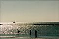
Shrimping and fishing in the Gulf
-
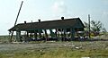
Damage in Cameron from Hurricane Rita (photo taken in April 2006)


See also
 In Spanish: Cameron (Luisiana) para niños
