
Galveston Bay facts for kids
Quick facts for kids Galveston Bay |
|
|---|---|

Satellite image of Galveston Bay. Galveston Island is at the bottom of the image, separated from Bolivar Peninsula by Bolivar Roads. A portion of Greater Houston is visible to the left.
|
|

Galveston Bay
Location in Texas
|
|
| Location | Texas Gulf Coast |
| Coordinates | 29°34′11″N 94°56′12″W / 29.56972°N 94.93667°W |
| Primary inflows | Trinity River, San Jacinto River |
| Ocean/sea sources | Gulf of Mexico |
| Basin countries | United States |
| Max. length | 30 miles (48 km) |
| Max. width | 17 miles (27 km) |
| Surface area | 345,280 acres (139,730 ha) |
| Average depth | 6 feet (1.8 m) |
| Max. depth | 10 feet (3.0 m) |
| Settlements | Houston, Pasadena, League City, Baytown, Texas City, Galveston, La Porte, Seabrook, Anahuac |
Galveston Bay is a large bay located on the upper coast of Texas, in the western Gulf of Mexico. It is the seventh-largest estuary in the United States. An estuary is a place where fresh river water mixes with salty ocean water.
This bay is the biggest of seven major estuaries along the Texas Gulf Coast. It connects to the Gulf of Mexico and is surrounded by marshes and grasslands. The water in the bay is a mix of fresh and salt water, which helps many different kinds of marine life to live there.
Galveston Bay is quite shallow for its size. Its deepest part is about 10 feet (3 meters), and its average depth is only 6 feet (1.8 meters).
The bay has been very important in the history of Texas. Galveston Island is home to the city of Galveston. This city was one of the first big settlements in southeast Texas. It was also the largest city in the state by the late 1800s.
A terrible hurricane in 1900 caused Galveston to decline. But the rise of Houston as a major trade center kept the bay important. This was helped by digging the Houston Ship Channel across the bay.
Today, Galveston Bay is part of Greater Houston, one of the largest metropolitan areas in the United States. The Port of Houston, located on the bay, is the second-busiest port in the nation. Other important ports are the Port of Texas City and the Port of Galveston. Galveston Bay also provides more seafood than almost any other estuary in the U.S.
Contents
History of Galveston Bay
The area around Galveston Bay changed a lot after the last Ice age, about 18,000 years ago. At that time, sea levels were low, and the Texas coast stretched much farther south. The Trinity River carved a deep canyon through what is now Bolivar Roads.
As the ice age ended, sea levels rose and filled this canyon. Then, they filled the wide, flat lands of what is now Trinity Bay. Between 7,700 and 5,500 years ago, the coastline moved north to where it is today. Soon after, Galveston Island (a barrier island) formed about 5,500 years ago. Bolivar Peninsula formed later, about 2,500 years ago.
People have lived in Texas for at least 10,000 years. The first main groups in the Galveston Bay area were the Karankawa and Atakapan tribes. They lived along the Gulf Coast.

Spanish explorers mapped the Gulf Coast. In 1785, explorer José Antonio de Evia named the bay and island Gálvezton. This was to honor the Spanish leader Bernardo de Gálvez.
Later, in 1816, Louis Aury set up a naval base there to help with the Mexican War of Independence. When he left, the pirate Jean Lafitte took over. He made Galveston Island a hideout for outlaws for a while. The United States Navy eventually forced him out.
After gaining independence from Spain, Mexico claimed Texas. Settlements grew around the bay, including Galveston, Anahuac, and San Jacinto. Texas later revolted and became independent in 1836 after the Battle of San Jacinto. The new Republic of Texas grew fast and joined the United States in 1845.
When the American Civil War began in 1861, Galveston residents supported the Confederacy. The Union navy blocked the city's harbor. In October 1862, Union forces occupied Galveston. However, in January 1863, a small Confederate force won the Battle of Galveston and took back the island. The Union still blocked the bay until the war ended.
After the war, the area recovered quickly. Ranching was a big business on the mainland. Galveston became a major U.S. port for shipping cotton, leather, cattle, and other goods. Railroads were built, and new towns appeared.

The Galveston Hurricane of 1900 caused huge damage to Galveston and nearby communities. Because of the hurricane, growth shifted inland to Houston. People were afraid to build businesses in Galveston. Texas City also became an important port.
Shipping through the bay grew a lot after 1914. The government finished digging the Houston Ship Channel to a depth of 25 feet (7.6 meters). The Texas oil boom started in 1901. By 1915, oil production and refineries were common around the bay.
Commercial fishing also grew after the 1920s, especially for oysters, fish, and shrimp. By the late 1930s, the Port of Houston was the largest cotton port in the U.S.

In 1963, NASA's Johnson Space Center was built near the bay in the Clear Lake Area. This brought new growth. By the 1970s, Houston was one of the nation's largest cities. Its growth connected it to the bay communities.
The bay's shoreline became very urbanized and industrialized. This led to pollution. In the 1970s, the bay was called "the most polluted body of water in the U.S." by a U.S. Representative.
Taking out oil and groundwater from the earth, plus large waves from ships, caused the land to sink and erode. This was especially true in the Baytown–Pasadena area. Over the last few decades, about 100 acres (40 hectares) of the historic San Jacinto battleground have gone underwater. Sylvan Beach, a popular spot, has eroded badly. The Brownwood neighborhood of Baytown was abandoned.
Today, the bay is a popular place for fun activities. These include boating, ecotourism (travel to natural areas), and waterfowl hunting.
Recent Incidents Affecting the Bay
2019 Cargo Plane Crash
On February 23, 2019, Atlas Air Flight 3591, a cargo plane, crashed into Trinity Bay near Anahuac, Texas. Both pilots and one passenger died. The plane was a Boeing 767. It was flying from Miami to Houston.
Before crashing, the plane made a sharp turn and went into a fast dive. Witnesses said it looked like a nosedive and heard loud sounds. Investigators found the flight recorders. They later said the crash happened because the co-pilot reacted incorrectly to a sudden change in the plane's controls. This caused him to lose his sense of direction, and the crew could not recover the plane in time.
2024 Oil Spill and Bridge Damage
On May 15, 2024, a tugboat lost control of two barges it was pushing. This happened near the Pelican Island causeway, which is the only bridge to Pelican Island. One barge hit the bridge and two telephone poles. This caused part of the bridge to collapse. It also led to a diesel fuel spill and a power outage on the island.
Two people fell or jumped off the barge but were quickly rescued. The bridge was closed. The barge spilled between 1,000 and 2,000 gallons (3,785 and 7,570 liters) of oil into Galveston Bay. Some oil stayed on the barge.
About 6.5 miles (10.5 kilometers) of the Gulf Intracoastal Waterway were closed to help clean up the oil. Officials asked the 200 people on Pelican Island to leave if they needed to. They warned that returning soon would be difficult.
Features of Galveston Bay

Galveston Bay covers about 600 square miles (1,550 square kilometers). It is 30 miles (48 kilometers) long and 17 miles (27 kilometers) wide. The bay is usually 6 feet (1.8 meters) deep, with a maximum natural depth of 10 feet (3 meters).
The Galveston Bay system has four main parts: Galveston Bay itself (upper and lower), Trinity Bay, East Bay, and West Bay. Three counties border the bay: Chambers, Harris, and Galveston.
Many cities are located around the bay. These include Houston, Pasadena, League City, Baytown, Texas City, Galveston, La Porte, Seabrook, and Anahuac.
Galveston Bay has three ways to connect to the Gulf of Mexico. These are Bolivar Roads (between Galveston Island and Bolivar Peninsula), San Luis Pass (at the west end of Galveston Island), and Rollover Pass (across Bolivar Peninsula). Many smaller bays and lakes also connect to the main system.
The Gulf Intracoastal Waterway, a path for boats, runs between the bay and the Gulf. Most of the fresh water flowing into the bay comes from the Trinity River. It brings about 7.5 million acre-feet (9.25 billion cubic meters) of water each year. The San Jacinto River adds another 500,000 acre-feet (617 million cubic meters).
Climate Around the Bay
The climate around Galveston Bay is called humid subtropical. This means it has hot, humid summers and mild winters. Winds from the south and southeast bring heat from Mexico and moisture from the Gulf of Mexico.
Summer temperatures often go above 90°F (32°C). The high humidity makes it feel even hotter. Winters are mild, with typical January highs above 60°F (16°C) and lows above 40°F (4°C). Snow rarely falls. The area gets a lot of rain, usually over 40 inches (1,000 mm) per year. Some places get over 50 inches (1,270 mm).
Hurricanes are a threat in the fall. Galveston Island and Bolivar Peninsula are most at risk. Even though they offer some protection, the bay shoreline can still be badly hit by storm surges. Hurricane Ike in 2008 caused a lot of damage to the bay.
There is a plan to build a flood barrier system, called the Ike Dike, to protect against future storm surges. In August 2017, Hurricane Harvey hit the Galveston Bay Area. It brought an extreme amount of rain, with many places getting over 30 inches (760 mm) in just a few days.
Ecosystem and Wildlife
The unique mix of fresh and salt water in Galveston Bay creates a perfect home for many types of marine life. This includes crabs, shrimp, oysters, and many kinds of fish. This supports a large fishing industry.
The deeper parts of the bay's shipping channels are good places for bottlenose dolphins to live. They eat the many fish found there. Also, the smaller rivers and marshes around the bay have their own ecosystems. They are home to diverse wildlife and allow for freshwater farming of crawfish.
The wetlands around the bay support many animals. Some notable land animals include the American alligator and the bobcat. Bird species include the roseate spoonbill, great and snowy egret, white-faced ibis, and mottled duck.
Pollution Concerns

In the early 1990s, the Houston Ship Channel had a very high level of toxic chemicals. This was due to waste from industries. However, the bay's water quality has generally improved since the Clean Water Act was passed in 1972.
Groups like the Houston Area Research Council (HARC) and Galveston Bay Foundation regularly check the bay's health. Their 2019 report gave a "C" grade for toxins in the bay's mud. They noted challenges like water and soil pollution, loss of animal homes, and effects of climate change.
The San Jacinto Pits Superfund site, which has a lot of dioxin, is a big threat to the bay's health. The entire bay has warnings about eating seafood from it. These warnings vary by location. In the Ship Channel, it's advised not to eat any fish or blue crab. In the lower bay, warnings only apply to catfish.
Oil spills happen often around Galveston Bay due to industrial activity. Hundreds of spills occur each year. On March 22, 2014, a barge carrying oil crashed with another ship in the Houston Ship Channel. This caused a large oil leak, which took weeks to clean up.
High levels of ozone (a type of air pollution) can also occur due to industries. Houston is one of the most ozone-polluted cities in the U.S. Industries along the ship channel are a main cause of this pollution.
Industry and Recreation

Galveston Bay is in Greater Houston, one of the largest metropolitan areas in the United States. This area is home to one of the nation's most important shipping centers. Houston, the fourth largest city in the U.S., is the economic and cultural hub of the region.
Important ports served by the bay include the Port of Houston, the Port of Texas City, and the Port of Galveston. The Houston Ship Channel, which connects the Port of Houston to the Gulf, goes through the bay. This channel was partly made by digging out the Buffalo Bayou and parts of Galveston Bay.
The area has many different industries. These include energy, manufacturing, space technology, transportation, and health care. Communities along the bay are home to the Johnson Space Center, which has the Christopher C. Kraft Jr. Mission Control Center. There is also Ellington Field Joint Reserve Base and many petrochemical refineries.
A large commercial fishing industry has grown around Galveston Bay. They catch a lot of shrimp, blue crab, eastern oysters, and various fish like black drum and flounder. In 2012, the commercial fish catch in Galveston Bay was about 5.8 million pounds (2.6 million kg). This was worth about $16.4 million.
Galveston Bay is also a popular place for fun and tourism. This is especially true because it is close to many people. Over 40% of people in Greater Houston go hiking and swimming along the bay each year. About 20% go fishing, and 15% go boating.
The five counties around the bay have 88,000 registered pleasure crafts (boats used for fun). Money spent on fishing activities, like buying bait or staying in hotels, brings in about $650 million each year. The recreational fishing industry supports over 3,000 jobs in the bay area.
With over 600 types of birds, Galveston Bay is a great place for birdwatching. This type of nature tourism brings millions of dollars each year to Chambers County. This county is home to the Anahuac National Wildlife Refuge and High Island.
Images for kids
-
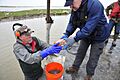
NTSB investigators recover the flight data recorder from Trinity Bay
.jpg)
See also
 In Spanish: Bahía de Galveston para niños
