
Baytown, Texas facts for kids
Quick facts for kids
Baytown, Texas
|
|
|---|---|
|
City
|
|
|
|
|

Baytown, Texas
Location in Texas

Baytown, Texas
Location in the United States

Baytown, Texas
Location in North America
|
|
| Country | |
| State | |
| Counties | Harris, Chambers |
| Congressional District | 36th |
| Incorporated | January 24, 1948 |
| Government | |
| • Type | Council–manager |
| Area | |
| • Total | 37.99 sq mi (98.39 km2) |
| • Land | 36.91 sq mi (95.59 km2) |
| • Water | 1.08 sq mi (2.80 km2) |
| Elevation | 23 ft (7 m) |
| Population
(2020)
|
|
| • Total | 83,701 |
| • Density | 2,091.58/sq mi (807.57/km2) |
| • Metro | 7,206,841 (6th) |
| Demonym(s) | Baytonian |
| Time zone | UTC-6 (CST) |
| • Summer (DST) | UTC-5 (CDT) |
| ZIP codes |
77520-77523
|
| Area code(s) | Area code 281 |
| FIPS code | 48-06128 |
| GNIS feature ID | 2409801 |

Baytown is a city in the U.S. state of Texas. It is located in Harris and Chambers counties. Baytown is part of the larger Houston–The Woodlands–Sugar Land area. It sits on the northern side of Galveston Bay, near where the San Jacinto River and Buffalo Bayou meet.
Baytown is the sixth-largest city in the Houston area. Major roads like State Highway 99, State Highway 146, and Interstate 10 serve the city. In 2020, Baytown had a population of 83,701 people.
Contents
History of Baytown
How Baytown Began
White American settlers first came to the Baytown area in 1822. One of the first settlers was Nathaniel Lynch. He started a ferry service where the San Jacinto River and Buffalo Bayou meet. This ferry, called the Lynchburg Ferry, still operates today. Other early settlers included William Scott and Ashbel Smith.
The city we know as Baytown was once three separate towns. The first town was called Goose Creek. It was named after a bayou where Canada geese used to spend the winter. The local school district still uses this name.
Oil Discovery and Growth
When oil was found at the Goose Creek Oil Field, two new towns grew quickly. These were Pelly, which started in the late 1910s, and East Baytown, which began in the early 1920s. The "East" was later dropped from East Baytown's name.
After World War I, people started talking about combining the three towns. However, the town of Baytown did not want to merge at first. Finally, in 1947, all three towns agreed to join together. They chose the name Baytown for their new combined city. Baytown was officially founded on January 24, 1948.
In 1916, the Humble Oil and Refining Company built the first offshore drilling operation in Texas. This was the second one in the entire United States. The company later built the Baytown Refinery, which became one of the largest Exxon refineries in the world. Many other refineries have been built in the area since then. Exxon-Mobil is still a major employer in Baytown.
Steel Industry in Baytown
Steel manufacturing started in Baytown in 1970. United States Steel opened the Texas Works plant near the city. This plant closed in 1986 due to economic problems. Later, Jindal Steel bought the mill. It now operates as JSW Steel USA, Inc.
Geography of Baytown

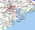
Baytown is located at the mouth of the San Jacinto River on Galveston Bay. It is about 26 miles (42 km) east of Houston by road. The city covers a total area of about 36.5 square miles (94.6 square kilometers). Most of this area is land, with a small part covered by water.
Baytown is on the Gulf coastal plain. The area has grasslands and marshes. Many parts of the city were built on reclaimed marshes, swamps, and prairies. You can still see these natural areas in undeveloped parts of the Galveston Bay area. Baytown is surrounded by water on three sides. Galveston Bay is to the south and west. Cedar Bayou is to the east. Interstate 10 generally forms the northern border. Some parts of the city east of Cedar Bayou are in Chambers County.
Because the land is flat and close to the bay, flooding can be a problem. Baytown used to get its water from underground. But too much water was pumped out, causing the land to sink. Now, the city mostly uses water from sources above ground.
Baytown's Geology
The land under Baytown is made of many layers of sand and clay. These layers formed over thousands of years from river sediments. They also contain plant and animal matter, which created the oil deposits found along the Gulf Coast.
The area around Baytown has many faults in the earth. Many of these faults are active, but they usually move slowly. This slow movement, called "fault creep", helps prevent big earthquakes. The only major earthquake reported in the area was caused by removing water and oil from underground.
Baytown's Climate
Baytown has a humid subtropical climate. This means it has hot, humid summers and mild winters. In spring, strong thunderstorms can sometimes cause tornadoes. Winds from the south and southeast bring heat from Mexico and moisture from the Gulf of Mexico.
Summer temperatures are usually around 90°F (32°C), but they can get hotter. Being close to the bay helps keep temperatures a bit cooler than inland cities like Houston. The bay winds also make the humidity feel less intense. Winters are mild, with January highs around 61°F (16°C) and lows around 42°F (6°C). Snow is very rare. Baytown gets a lot of rain, averaging over 60 inches (152 cm) per year.
Sometimes, there are high levels of ozone in the air due to industrial activities. Nearby Houston is one of the most ozone-polluted cities in the U.S. Industries along the ship channel and the bay are a main cause of this pollution.
Hurricanes are a big concern in the fall. Even though Galveston Island and the Bolivar Peninsula offer some protection, Baytown is still more at risk than Houston. This is especially true because of storm surge and land sinking in some low areas. Major hurricanes that have affected Baytown include Hurricane Carla (1961), Hurricane Alicia (1983), Hurricane Ike (2008), and Hurricane Harvey (2017).
| Climate data for Baytown, Texas (1991–2020 normals, extremes 1983–present) | |||||||||||||
|---|---|---|---|---|---|---|---|---|---|---|---|---|---|
| Month | Jan | Feb | Mar | Apr | May | Jun | Jul | Aug | Sep | Oct | Nov | Dec | Year |
| Record high °F (°C) | 83 (28) |
86 (30) |
90 (32) |
93 (34) |
96 (36) |
102 (39) |
102 (39) |
107 (42) |
109 (43) |
94 (34) |
88 (31) |
84 (29) |
109 (43) |
| Mean maximum °F (°C) | 76.7 (24.8) |
79.5 (26.4) |
82.8 (28.2) |
86.3 (30.2) |
90.6 (32.6) |
95.5 (35.3) |
97.3 (36.3) |
98.5 (36.9) |
95.2 (35.1) |
90.4 (32.4) |
84.0 (28.9) |
79.1 (26.2) |
99.6 (37.6) |
| Mean daily maximum °F (°C) | 62.9 (17.2) |
66.4 (19.1) |
72.1 (22.3) |
77.5 (25.3) |
84.2 (29.0) |
89.2 (31.8) |
91.5 (33.1) |
92.3 (33.5) |
88.5 (31.4) |
81.6 (27.6) |
71.4 (21.9) |
64.5 (18.1) |
78.5 (25.8) |
| Daily mean °F (°C) | 52.1 (11.2) |
55.8 (13.2) |
62.0 (16.7) |
68.0 (20.0) |
75.4 (24.1) |
80.9 (27.2) |
83.1 (28.4) |
83.3 (28.5) |
78.8 (26.0) |
70.6 (21.4) |
60.7 (15.9) |
54.1 (12.3) |
68.7 (20.4) |
| Mean daily minimum °F (°C) | 41.4 (5.2) |
45.3 (7.4) |
52.0 (11.1) |
58.5 (14.7) |
66.7 (19.3) |
72.7 (22.6) |
74.6 (23.7) |
74.3 (23.5) |
69.0 (20.6) |
59.6 (15.3) |
50.1 (10.1) |
43.6 (6.4) |
59.0 (15.0) |
| Mean minimum °F (°C) | 28.4 (−2.0) |
32.6 (0.3) |
36.2 (2.3) |
44.4 (6.9) |
54.2 (12.3) |
65.9 (18.8) |
71.1 (21.7) |
70.5 (21.4) |
58.4 (14.7) |
45.5 (7.5) |
35.5 (1.9) |
31.2 (−0.4) |
26.7 (−2.9) |
| Record low °F (°C) | 17 (−8) |
14 (−10) |
25 (−4) |
30 (−1) |
43 (6) |
58 (14) |
62 (17) |
58 (14) |
48 (9) |
30 (−1) |
25 (−4) |
7 (−14) |
7 (−14) |
| Average precipitation inches (mm) | 4.85 (123) |
3.78 (96) |
3.94 (100) |
4.51 (115) |
6.01 (153) |
7.08 (180) |
5.49 (139) |
6.82 (173) |
6.41 (163) |
6.13 (156) |
4.94 (125) |
4.77 (121) |
64.73 (1,644) |
| Average snowfall inches (cm) | 0.0 (0.0) |
0.0 (0.0) |
0.0 (0.0) |
0.0 (0.0) |
0.0 (0.0) |
0.0 (0.0) |
0.0 (0.0) |
0.0 (0.0) |
0.0 (0.0) |
0.0 (0.0) |
0.0 (0.0) |
0.0 (0.0) |
0.0 (0.0) |
| Average precipitation days (≥ 0.01 in) | 10.6 | 9.3 | 9.0 | 7.9 | 7.7 | 10.1 | 10.1 | 10.7 | 9.7 | 7.1 | 8.3 | 10.5 | 111.0 |
| Average snowy days (≥ 0.1 in) | 0.0 | 0.0 | 0.0 | 0.0 | 0.0 | 0.0 | 0.0 | 0.0 | 0.0 | 0.0 | 0.0 | 0.0 | 0.0 |
| Source: NOAA | |||||||||||||
People of Baytown
| Historical population | |||
|---|---|---|---|
| Census | Pop. | %± | |
| 1950 | 22,983 | — | |
| 1960 | 28,159 | 22.5% | |
| 1970 | 43,980 | 56.2% | |
| 1980 | 56,923 | 29.4% | |
| 1990 | 63,850 | 12.2% | |
| 2000 | 66,430 | 4.0% | |
| 2010 | 71,802 | 8.1% | |
| 2020 | 83,701 | 16.6% | |
| U.S. Decennial Census 1850–1900 1910 1920 1930 1940 1950 1960 1970 1980 1990 2000 2010 |
|||
Baytown's Population in 2020
| Race / Ethnicity (NH = Non-Hispanic) | Pop 2000 | Pop 2010 | Pop 2020 | % 2000 | % 2010 | % 2020 |
|---|---|---|---|---|---|---|
| White alone (NH) | 33,328 | 27,803 | 24,137 | 50.17% | 38.72% | 28.84% |
| Black or African American alone (NH) | 8,726 | 10,759 | 13,652 | 13.14% | 14.98% | 16.32% |
| Native American or Alaska Native alone (NH) | 181 | 180 | 233 | 0.27% | 0.25% | 0.28% |
| Asian alone (NH) | 634 | 1,022 | 1,447 | 0.95% | 1.42% | 1.73% |
| Pacific Islander alone (NH) | 32 | 24 | 42 | 0.05% | 0.03% | 0.05% |
| Some Other Race alone (NH) | 49 | 132 | 526 | 0.07% | 0.18% | 0.63% |
| Mixed race or Multiracial (NH) | 732 | 726 | 2,250 | 1.10% | 1.01% | 2.69% |
| Hispanic or Latino (any race) | 22,748 | 31,156 | 41,414 | 34.24% | 43.39% | 49.48% |
| Total | 66,430 | 71,802 | 83,701 | 100.00% | 100.00% | 100.00% |
The 2020 United States census showed that Baytown had 83,701 people. This was an increase from 71,802 people in 2010. In 2020, there were 26,592 households and 18,169 families living in the city.
In 2019, the U.S. Census Bureau estimated the city's population was about 31.8% non-Hispanic white. About 17.2% were Black or African American. Around 1.8% were Asian, and 2.0% were from two or more races. About 47.0% of the people in Baytown were Hispanic or Latin American. The largest Hispanic group was Mexican Americans.
In 2010, about 39.2% of households had children under 18. About 52.9% were married couples. The average household had 2.80 people, and the average family had 3.32 people.
The average income for a household in Baytown was $57,765 in 2019. About 14.0% of the population lived at or below the poverty line. The average value of homes owned by residents was $133,900 in 2019.
Religions in Baytown
Christianity is the most common religion in Baytown and the Houston area. The Latin Church's Archdiocese of Galveston-Houston is the largest Christian group. Other large Christian groups include Baptists and United Methodist Church. Other important religions in Baytown are Judaism and Islam.
Baytown's Economy

Baytown's economy is centered around three industrial areas. These areas are outside the city limits but are still important to Baytown. They mainly focus on processing petroleum and petrochemicals. Key companies in the area include ExxonMobil, Covestro, and Chevron Phillips.
The ExxonMobil Baytown Complex started in 1919. It is one of the largest industrial sites in the world. The Baytown Refinery there is the biggest in the United States. The Covestro Baytown Industrial Park is Covestro's largest chemical processing site in the U.S. The Cedar Bayou plant is Chevron Phillips Chemical's largest manufacturing site in the United States. This area is growing and attracting new companies like Jindal Steel and Power Limited and Samson Controls.
Baytown is also home to the Cedar Crossing Industrial Park. This park is huge, covering 15,000 acres. It is considered the fifth largest industrial park in the world. Many big companies have operations here. These include Home Depot and Walmart distribution centers. JSW Steel and Borusan Mannesmann also have manufacturing facilities here.
Culture and Fun in Baytown

Arts and Culture
The Downtown Arts District in Baytown has many arts and culture programs. These include the Baytown Little Theater, Lee College Performing Arts Center, and the Art Gallery of Baytown.
- The Baytown Little Theater is a community theater run by volunteers. It has been active for over 55 years. The theater usually puts on six shows each year. They are known for their summer musical.
- The Lee College Performing Arts Center hosts theater shows, symphony performances, and art exhibits. The Baytown Symphony Orchestra performs concerts here.
- The Art Gallery of Baytown is home to the Art League of Baytown. This group started in 1954. The gallery displays art made by local artists. You can also buy unique art, pottery, and jewelry there.
The City of Baytown Tourism Division leads the Baytown Public Art Program. This program helps bring public art to the city.
Things to Do and See

- The Baytown Nature Center is a 450-acre (1.8 km²) area. It is a recreation spot and a wildlife sanctuary. It is home to many kinds of birds, mammals, reptiles, and water animals.
- Houston Raceway is a place for motorsports. It hosts National Hot Rod Association (NHRA) races and weekly drag racing. It can hold 40,000 fans.
Media in Baytown
The Baytown Sun is the city's local newspaper. News from Houston's television, newspaper, and radio stations also covers Baytown. This is because Baytown is part of the larger Greater Houston metropolitan area.
Education in Baytown
Colleges
Lee College is a two-year community college that serves East Harris County and West Chambers County.
Schools for Kids
Baytown is served by the Goose Creek Consolidated Independent School District. This district has 14 elementary schools (grades K–5), 5 junior high schools (grades 6–8), and 3 high schools (grades 9–12). The high schools are Robert E. Lee (opened 1928), Ross S. Sterling (opened 1966), and Goose Creek Memorial High School (opened 2008).
Stallworth Stadium is where the GCCISD high schools play varsity football and soccer. It also hosts the annual Bayou Bowl. The stadium can seat about 16,000 fans. This makes it one of the largest high school sports venues in the country.
There are also four private schools in the area:
- Baytown Christian Academy
- Chinquapin Preparatory School
- Light House Baptist Academy
- St. Joseph Regional Catholic School (part of the Roman Catholic Archdiocese of Galveston-Houston)
Getting Around Baytown

Harris County Transit provides public transportation in Baytown. There is a Park and Ride lot on the west side of San Jacinto Mall. Harris County Transit also has a bus line that connects major shopping areas with Lee College.
Greyhound Bus Lines operates a station in Baytown.
For air travel, Baytown Airport is a private airport north of Baytown. RWJ Airpark is another private airport east of Baytown. The closest airports with commercial flights are William P. Hobby Airport and George Bush Intercontinental Airport in Houston.
Baytown is connected to Interstate 10 by State Highway 99, State Highway 146, and Spur 330. The Fred Hartman Bridge connects Baytown to nearby La Porte. This bridge was built in 1995 to allow for a deeper ship channel, replacing the old Baytown Tunnel.
Famous People from Baytown
Many notable people have connections to Baytown:
- Rocky Bernard – NFL defensive tackle
- Gary Busey – Actor, born in Goose Creek
- Chris Cagle – Country music artist
- Quentin Coryatt – Former NFL player
- Macey Cruthird – Actress, born in Baytown
- Bobby Fuller – Rock musician, born in Baytown
- John Hagee – Pastor, born in Baytown
- Bob Lanier – Former Mayor of Houston, born and raised in Baytown
- Romany Malco – Actor/rapper, attended Ross S. Sterling High School
- Leeland Mooring – Lead singer for Christian band Leeland
- RaeLynn – Country music star from The Voice
- Clint Stoerner – Former NFL and college quarterback
- Joe Tex – Popular R&B singer
- Buddy Wakefield – Champion slam poet, raised in Baytown
- Glenn Wilson – Former Major League Baseball outfielder
Images for kids
-
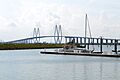
Fred Hartman Bridge
-
Baytown connects to I-10 via State Highways 99 and 146, and the Fred Hartman Bridge connects SH 146 southwest to La Porte.
-

Baytown Refinery
-

Texas Street Fest in Baytown, Texas
-
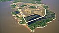
Baytown Nature Center
-
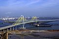
The Fred Hartman Bridge, which connects Baytown to La Porte
See also
 In Spanish: Baytown para niños
