
Buffalo Bayou facts for kids
Quick facts for kids Buffalo Bayou |
|
|---|---|

An unchannelized section of Buffalo Bayou near Memorial Park in Houston
|
|
| Country | |
| State | |
| County | Fort Bend, Harris |
| Physical characteristics | |
| Main source | Junction of Willow Fork and Cane Island Branch Katy, Texas 29°46′04″N 95°49′33″W / 29.767895°N 95.825756°W |
| River mouth | Galveston Bay 29°45′41″N 95°05′13″W / 29.761408°N 95.086903°W |
| Length | 53 miles (85 km) |
| Basin features | |
| Basin size | 500 square miles (1,300 km2) |
| Population | 440,000 |
| Tributaries |
|
| Inland ports | Houston Ship Channel, Port of Houston |
Buffalo Bayou is a slow-moving waterway that flows through Houston in Harris County, Texas. It began forming about 18,000 years ago. The bayou starts in the prairie near Katy, Fort Bend County. It then flows about 53 miles (85 km) east. It passes through the Houston Ship Channel to reach Galveston Bay and the Gulf of Mexico.
The bayou gets its water from several places. These include natural springs and rainwater runoff. It also gets water from important smaller waterways called tributaries. Some of these are White Oak Bayou, Greens Bayou, and Brays Bayou. Water from the Addicks and Barker reservoirs also feeds the bayou. Buffalo Bayou is also a tidal river in its lower sections. This means its water levels change with the ocean tides.
Buffalo Bayou is the main river in the Greater Houston area. Its watershed, which is the land area that drains into the bayou, is very developed. About 440,000 people live in its direct drainage area. This area covers about 102 square miles (260 km2). Including all its tributaries, the bayou's watershed is about 500 square miles (1,300 km2).
Contents
Exploring Buffalo Bayou's Path


The upper part of Buffalo Bayou is controlled by the Addicks and Barker reservoirs. These are big dams that help control floods in the area. They slow down and reduce the amount of water flowing in the river during heavy rains.
Moving east, Buffalo Bayou flows under State Highway 6. It then enters Terry Hershey Park. This park follows the bayou for about 6 miles (9.7 km). It ends at Beltway 8.
The bayou winds through the Memorial Villages between Beltway 8 and Loop 610. Most of the land along this part is private. However, you can access the bayou at Briarbend Park. This park has a public launch for canoes and kayaks. Another launch is near Loop 610 on Woodway. You can also get to the bayou from public road bridges.
East of Loop 610, Buffalo Bayou flows past Memorial Park. It also runs along the River Oaks Country Club. You can access the bayou from the Memorial Park side. Bayou Bend Collection and Gardens, a famous estate, is on the north bank. After Shepherd Drive, the bayou enters Buffalo Bayou Park. This park stretches for 2.3 miles (3.7 km) to Interstate 45.
The bayou then flows into Downtown Houston. It passes Allen's Landing and joins White Oak Bayou. After leaving downtown, the bayou gets much wider. It eventually reaches the Houston Ship Channel.
Buffalo Bayou's Past
How Early Settlements Grew
Buffalo Bayou was a key area for early American settlers in Texas. This was when Texas was part of the Spanish Empire and then Mexico. Communities like Lynchburg and Harrisburg appeared in the 1820s. The bayou became very important during the Battle of San Jacinto. This final battle for Texas Independence happened where the bayou meets the San Jacinto River.
In the 1830s, new towns like Houston were built along the bayou. Docks in Harrisburg, Houston, and the Allen Ranch became the start of the Port of Houston. Harrisburg was the main trade center until the 1870s. After a big fire, its railroad facilities moved to Houston.
Houston's first docks, now called Allen's Landing, were at the meeting point of Buffalo Bayou and White Oak Bayou. The first docks opened in 1840, and the Port of Houston started in 1841. Only small ships could reach the city without a lot of digging. Today, this spot is a public park near the University of Houston–Downtown.
After the American Civil War, the local economy grew. Digging out the bayou became more possible. The Bayou Ship Channel Company started major digging in 1870. The city also got help from the government for the project. This first big digging of Buffalo Bayou finished in 1876.

By the mid-1900s, the Port of Houston was the top port in Texas. It became bigger than the natural harbors at Galveston and Texas City. The Turning Basin in Harrisburg became the port's busiest shipping area. The Texas oil boom in the early 1900s also led to more industrial growth.
Controlling Floods and Protecting Nature
Big floods in the early 1900s, especially in 1929 and 1935, caused much damage in Downtown Houston. This led to government-funded projects to control floods. The Texas Legislature created the Harris County Flood Control District (HCFCD) in 1937. By the late 1930s, over $35 million was set aside for a large drainage program.
In western Harris County, the United States Army Corps of Engineers built the Barker Reservoir (finished 1945) and Addicks Reservoir (finished 1948). These reservoirs can hold a lot of runoff water. This has largely stopped floods downstream. Six miles of Buffalo Bayou were straightened when the reservoirs were built. Later, another section was straightened between 1953 and 1958. However, the part of the bayou that runs through the Memorial Villages has stayed natural and winding.
In the 1960s, a local conservationist named Terry Hershey worked with George H. W. Bush, who later became president. They stopped the government from lining parts of the bayou with concrete. In 1966, Hershey and others formed the Buffalo Bayou Preservation Association. This group later became the Bayou Preservation Association. In 1989, Terry Hershey Park was named after her efforts. Buffalo Bayou is one of the few waterways in Houston that still has its natural riverside environment.
After the Clean Water Act passed in 1972, Houston worked to stop untreated sewage from going into the bayous. The city has spent over $3 billion on new sewers and treatment plants. This has greatly improved the water quality.

In 1986, the Buffalo Bayou Partnership was started. This group works to improve and expand park areas along the river. Their 2002 plan aimed to create a series of linear parks through central Houston. The goals included restoring natural habitats and adding trails for hiking and biking. They also planned for canoeing and kayaking facilities.
The Partnership has raised over $150 million for these projects. The Buffalo Bayou Promenade opened in 2006. It has 1.4 miles (2.3 km) of trails. In 2015, Buffalo Bayou Park was completed. This added another 160 acres (65 hectares) of parkland. The park includes a dog park, gardens, and restaurants. It also has an art space inside an old underground cistern. Since 2006, the Houston Cistern has offered historical tours and art exhibits.
In August 2017, Hurricane Harvey brought huge amounts of rain. Buffalo Bayou reached record high levels. The Addicks and Barker reservoirs filled up completely. The U.S. Army Corps of Engineers had to release water to prevent the dams from breaking. Even with these efforts, some uncontrolled releases happened. This caused major flooding along the western part of Buffalo Bayou. The Memorial area was badly damaged.
What the Watershed Does
Controlling Floods
The Buffalo Bayou watershed is very important for draining water from Houston and Harris County. The land is flat and has soils that don't absorb water well. This means the bayou naturally has large floodplains. As more buildings were built in the watershed, more people became at risk from floods. This also changed how often and how badly floods happened.
After the terrible flood of 1935, the U.S. Army Corps of Engineers and the Harris County Flood Control District started a big program. They built reservoirs and removed plants from riverbanks. They also straightened parts of the river. This was all to reduce Houston's flood risk. The two main flood control features are the Addicks and Barker reservoirs. They provide a combined 26,000 acres (11,000 hectares) of open land to store runoff water. In recent years, a lot of new homes have been built upstream of these reservoirs. This has put more stress on the flood control system.
Since 2015, Buffalo Bayou has had three major floods. These include Hurricane Harvey in 2017, the Tax Day floods of 2016, and a flood on May 26, 2015.
Fun and Wildlife
Buffalo Bayou is home to many urban parks. These include George Bush Park, Terry Hershey Park, Memorial Park, Buffalo Bayou Park, and Marron Park. The San Jacinto Battleground State Historic Site is where the Battle of San Jacinto took place. It includes the USS Texas, a museum ship docked near the bayou's mouth.
The bayou has many fish like catfish, sunfish, gars, and bass. People enjoy fishing here. It also has many birds and is home to the popular Waugh Bat Bridge. Alligators have also been seen along the bayou.
Boating and Paddling
You can legally paddle on Buffalo Bayou from its start in Katy to the western end of the Ship Channel. Most people paddle between Highway 6 and Shepherd Drive. The most popular sections are from Briarbend Park to Woodway and to Downtown Houston. This is because they are easy to access.
The section from Highway 6 to Beltway 8 often has fallen trees. This means you might have to carry your boat around them. The Harris County Flood Control District usually keeps the sections from Beltway 8 to Woodway clear. However, there might be trees blocking the way right after storms.
Water Quality
As a city waterway, Buffalo Bayou can easily have low water quality. The condition of the bayou's water has always been a concern in Houston. In the 1800s, the river was used for sewage and as a source of drinking water. Factories and farms often dumped waste into the water. The bayou became known as a "cesspool" with a "terrible smell." It wasn't until the early 1900s that the city built sewers and sewage treatment plants. But progress was slow, and Buffalo Bayou was still very polluted in the late 1940s.
Today, the bayou still faces big environmental problems. These include high levels of certain bacteria and low oxygen. There is also a lot of nutrient pollution.
In February 2019, about 64,000 gallons of jet fuel leaked into the bayou. This happened from the nearby Hobby Airport.
Images for kids
-
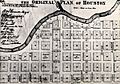
The "Original Plan of Houston" shows a city hugging Buffalo Bayou with space reserved for a courthouse, churches, and schools. (1869)
-
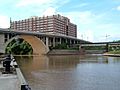
Merger of Buffalo Bayou and White Oak Bayou at Allen's Landing
-

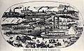
Boats in Buffalo Bayou in 1910
-
Postcard Illustration of Allen's Landing (1910)
-
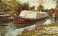
Cotton barge on Buffalo Bayou (postcard, 1908)
-
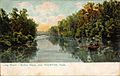
Long Reach, Buffalo Bayou, Houston, Texas (postcard, circa 1908)
-
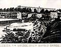
International and Great Northern Railroad bridge over Buffalo Bayou


.jpg)
.jpg)

