Brays Bayou facts for kids
Quick facts for kids Brays Bayou |
|
|---|---|

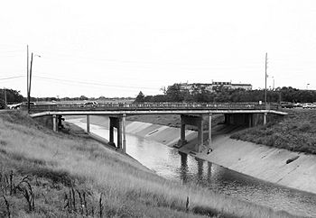
Almeda Road bridge over Brays Bayou near Hermann Park.
|
|
| Other name(s) | Braes Bayou, Bray's Bayou |
| Country | |
| State | |
| County | Harris |
| Physical characteristics | |
| Main source | Detention basin Western Harris County 29°42′45″N 95°40′21″W / 29.712394°N 95.672520°W |
| River mouth | Buffalo Bayou Harrisburg, Houston 29°43′37″N 95°16′37″W / 29.726926°N 95.276936°W |
| Length | 31 miles (50 km) |
| Basin features | |
| Basin size | 129 square miles (330 km2) |
| Population | 717,198 |
| Tributaries |
|
Brays Bayou is a slow-moving river in Harris County, Texas. It's a major branch of Buffalo Bayou. Brays Bayou flows for about 31 miles (50 km). It starts in the western part of Harris County. It then flows east until it meets Buffalo Bayou in Harrisburg.
Most of the river is inside the city of Houston. It's a key natural feature for many neighborhoods. These include Meyerland, Braeswood Place, the Texas Medical Center, and Riverside Terrace. The land around Brays Bayou is very developed. Over 700,000 people live in its 129 square mile (334 km2) drainage area. This area has 124 miles (200 km) of waterways. Because of all the buildings and roads, Brays Bayou often experiences sudden floods.
Contents
What's in a Name?
The exact origin of the name Brays Bayou isn't fully clear. You might see it spelled Braes or Bray's sometimes. For example, the neighborhood of Braeswood Place and Braeswood Boulevard use the Braes spelling. This area is near the bayou, southwest of Rice University.
One idea is that Braeswood comes from the Scottish word brae. This word means a hill or a slope. An early settler named Henry MacGregor lived along the bayou. He might have given it this name.
The name Brays has been used since the 1820s. That's when the first settlers, called the Old Three Hundred, arrived. In 1822, a man named Bray settled near the bayou. He might be the person it was named after.
Where Does Brays Bayou Flow?
Brays Bayou starts at a special pool built to hold stormwater. This pool is in western Harris County, south of Barker Reservoir. From there, it flows east. It passes north of Mission Bend and goes into Alief.
After a short time in Westchase, the bayou turns south. It goes through the International District. Then it runs along the western edge of Sharpstown. After passing under Interstate 69, the bayou flows east-northeast. It goes through Meyerland and under Interstate 610. It then flows past the Texas Medical Center and Hermann Park.
The bayou then goes under State Highway 288. It enters the Third Ward. After passing under Interstate 45, it flows into the East End. At this point, Brays Bayou becomes much wider. Finally, it empties into Buffalo Bayou. This happens near the Houston Ship Channel and the historic town of Harrisburg.
A Look Back in Time
The spot where Brays Bayou meets Buffalo Bayou was important for early settlers. The town of Harrisburg was founded there in 1825. Later, in 1836, Houston was founded further upstream on Buffalo Bayou. Harrisburg was the main trading center for a while. But after the American Civil War, Houston became more important.
Other early communities along Brays Bayou included Riceville, started in 1850, and Alief, started in 1861. The area around Brays Bayou often flooded. This made the land perfect for growing rice. Rice became a very important crop in Alief in the early 1900s. Because Alief knew a lot about flooding, it created the region's first flood control district in 1909.

By the mid-1900s, Houston's suburbs reached Brays Bayou. Rice University was built near the bayou in 1912. The University of Houston was built just north of the bayou in 1927. Harrisburg became part of Houston in 1926. In the 1930s, Riverside Terrace became home to large estates. These were owned by wealthy families who were looking for new communities. The Texas Medical Center started in the 1940s. This was when the MD Anderson Cancer Center was built. Meyerland opened in 1955. It was one of Houston's first planned communities. Brays Bayou still connects these important areas.
Like many other Houston bayous, Brays Bayou was changed by engineers. The United States Army Corps of Engineers straightened and widened parts of it. This happened between 1955 and 1960. They did this after big floods in the early 1950s. By 1980, over 412,000 people lived in the Brays Bayou area. But there were still problems with drainage. A flood in 1976 caused a lot of damage. It hit the Medical Center, Rice University, and the University of Houston. In the 1970s, the Harris County Flood Control District started making rules. These rules aimed to reduce flooding by controlling new buildings upstream.
In 2001, Tropical Storm Allison caused huge damage. It was one of the most destructive tropical storms in U.S. history. About 6,000 homes along Brays Bayou were flooded. The Texas Medical Center was also flooded. This damaged important medical buildings.
In May 2015, heavy rain caused over 400 homes in Meyerland to flood. One year later, in April 2016, the neighborhood flooded again. In 2017, Hurricane Harvey brought even worse flooding to the area.
Project Brays: Fighting Floods
Project Brays is a big project to help control floods. It's officially called the Brays Bayou Federal Flood Risk Reduction Project. The U.S. Army Corps of Engineers and the Harris County Flood Control District are working on it. The project costs $480 million. It aims to add new and better flood control systems to Brays Bayou.
Project Brays includes 75 different parts. These include making 21 miles (34 km) of the bayou deeper and wider. They are also changing or rebuilding 30 road bridges. Plus, they are building four large stormwater detention basins. These basins can hold a total of 3.5 billion gallons (13.2 billion liters) of water.
Planning for Project Brays started in 1988. Construction began in 2001. The project has been delayed sometimes. This is because of gaps in federal funding. But the serious floods in 2015 and 2016 made people want to finish it faster. Once finished, Project Brays will protect 15,000 buildings. These buildings are currently at risk of flooding during a 100-year flood (a flood with a 0.1% chance of happening in any given year).
Brays Bayou Parks
The Brays Bayou Greenway is a great linear park in Houston. It has 30 miles (48 km) of trails for walking and biking. These trails are separate from roads. The City of Houston has a project called Bayou Greenways 2020. This project focuses on Brays Bayou. It aims to connect parts of the trail network. It also adds new park spaces. Plus, it makes it easier to get to nearby neighborhoods and cross the bayou.
Some public parks connected to the greenway are:
- Mike Driscoll Park
- Arthur Storey Park
- Hermann Park
- MacGregor Park
- Mason Park
Arthur Storey Park is also a large stormwater detention basin. It can hold up to 1.1 billion gallons (4.2 billion liters) of water. This helps a lot during flood events.
 | Chris Smalls |
 | Fred Hampton |
 | Ralph Abernathy |

