
Interstate 69 facts for kids
Quick facts for kids
|
|
|---|---|
| Lua error in Module:Infobox_road/map at line 15: attempt to index field 'wikibase' (a nil value). | |
| Route information | |
| Length | 355.8 mi (572.6 km)
(original route; 1.73 mi (2.78 km) part opened near Evansville, Indiana on September 29, 2009. 42.0 mi (70.0 km) are open in MS and TN)
|
| Existed | 1956 (orig. route completed 1992)–present |
| Major junctions | |
| Original South end | |
| North end | |
| Highway system | |
| Main route of the Interstate Highway System Main • Auxiliary • Business |
|

Interstate 69 (often called I-69) is a major highway in the United States. It is part of the Interstate Highway System, a network of important roads that connect states. The main section of I-69 stretches from Indianapolis, Indiana, all the way north to Port Huron, Michigan. This northern end is right at the border with Canada. This main part of the highway is about 355.8 miles (572.6 kilometers) long.
Besides the main section, there are also other parts of I-69 in Mississippi and near Evansville, Indiana. These sections are not yet connected to the main highway. They will become part of a much longer I-69 in the future. This larger plan aims to connect Indianapolis southwest all the way to Texas.
Contents
What is Interstate 69?
Interstate 69 is a very important road. It helps people travel and goods move across different states. It is built to high standards, which means it's usually a smooth and fast way to get around. These highways are designed for safe, long-distance travel.
Where Does I-69 Go?
The main part of I-69 starts in Indianapolis, Indiana. From there, it heads north through Indiana and into Michigan. It passes by cities like Fort Wayne and Lansing. Finally, it reaches Port Huron, Michigan, where it connects to a highway in Canada.
Connecting States and Cities
I-69 connects with many other major highways along its path. For example, in Indiana, it meets Interstate 465 and I-80/I-90. In Michigan, it crosses paths with I-94, I-96, and I-75. These connections make it easy for drivers to switch between different major routes.
The Future of Interstate 69
The plan for I-69 is to make it much longer. The goal is to create a continuous highway from the Canadian border all the way to the Mexican border in Texas. This is a huge project that has been happening in stages.
Why Expand I-69?
Expanding I-69 will help connect more parts of the country. It will make it easier for trucks to carry goods, which helps businesses. It will also make travel simpler for people driving long distances. This expansion is expected to boost the economy in the areas it passes through.
New Sections Opening
Some new parts of I-69 have already opened. For example, a section near Evansville, Indiana, opened in 2009. There are also parts open in Mississippi and Tennessee. These new sections are slowly being built to connect to each other and to the main I-69 highway. The plan is to eventually link these separate parts into one long road.
Images for kids
-

Looking on I-69 just outside Indianapolis near Pendleton
-

I-69's northern end at the Blue Water Bridge in Port Huron, Michigan, connecting to Highway 402 in Canada.
-

A future connection from I-610 to I-69 in Houston, Texas.
-

The Southwest Freeway, which is now part of I-69, in Houston in 1972.
-

A section of I-69 that shares its path with MS 304 in Mississippi.
-

Future I-69 alongside US 49, US 61, and US 278 near Clarksdale, Mississippi.
-

I-69 sharing its route with the Western Kentucky Parkway near Dawson Springs, Kentucky.
-
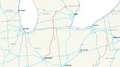
A map showing the original route of I-69.
-

This sign shows that US 59 will become I-69W in the future, near Laredo, Texas.


.JPG)


