
Houston Ship Channel facts for kids

The Houston Ship Channel is a very important waterway in Houston, Texas. It is part of the Port of Houston, which is one of the busiest seaports in the world. This channel acts like a highway for large ships that travel between Houston and the Gulf of Mexico. It also helps move many smaller barges.
Contents
What is the Houston Ship Channel?

The channel was made by digging out and making Buffalo Bayou and Galveston Bay wider and deeper. This process is called dredging. The channel starts about four miles east of downtown Houston at a place called the Turning Basin. It ends at the Gulf of Mexico, between Galveston Island and the Bolivar Peninsula.
What Travels on the Channel?
Many different goods travel on the channel. These include petrochemicals (chemicals made from oil and gas) and Midwestern grain. Other general cargo also moves through this busy waterway. The original water source for the channel, Buffalo Bayou, starts about 30 miles (48 km) west of Houston. The Turning Basin is the furthest point upstream where large cargo ships can go.
Terminals and Crossings
The channel has many places where ships can load and unload goods. These are called terminals and berthing locations. Some of the main public terminals are Turning Basin, Barbours Cut, and Bayport. There are also many private docks, like the ExxonMobil Baytown Complex.
The channel is about 530 feet (160 m) wide, 45 feet (14 m) deep, and 50 miles (80 km) long. It has been made wider and deeper over time for bigger ships. The islands you see in the channel are made from the soil that is dug up during dredging. These islands are important for salt marshes and birds.
There are five ways to cross the channel for vehicles. These include the Washburn Tunnel, the Sidney Sherman Bridge, and the Sam Houston Ship Channel Bridge. There is also the Fred Hartman Bridge and the Lynchburg Ferry.
How the Channel Grew

The area around the channel has been used for moving goods since at least 1836. A man named John Richardson Harris started a town called Harrisburg in 1826. He used a schooner (a type of sailing ship) to bring supplies and export cotton. However, the nearby Brazos River was hard to navigate because of shallow sandbars.
Early Challenges and Growth
Another early trader, Nicholas Clopper, also faced challenges. His sons wrote in a journal about their ship running aground and seeing other wrecked ships. They also had trouble with a shallow area called Red Fish Bar.
To make it easier for larger ships, Buffalo Bayou and Galveston Bay were dredged in the late 1800s and early 1900s. After a big hurricane hit Galveston in 1900, people realized that an inland port like Houston would be safer. This led to plans for an even bigger ship channel. By the mid-1900s, the Port of Houston became the most important port in Texas.
Opening and Expansion
On January 10, 1910, people in Harris County voted to pay for dredging the channel to a depth of 25 feet. The government also provided money. On June 14, 1914, the first large ship, the Satilla, arrived in Houston. This started regular ship service between New York City and Houston.
President Woodrow Wilson officially opened the Houston Ship Channel on November 10, 1914. The start of World War I soon after meant a huge need for oil. This greatly increased how much the channel was used.
The United States Army Corps of Engineers made the channel deeper over the years. It went from 25 feet to 30 feet in 1922. In 1933, plans were approved to make it 34 feet deep and wider in Galveston Bay. This project finished in 1935.
Industry and History
Because Texas has many oilfields, many refineries were built along the channel. Today, the channel area is home to the second-largest petrochemical complex in the world.
.jpg)
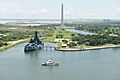
Even with all the industry, two important parts of Texas history are also along the channel. The USS Texas (BB-35) is an old battleship that served in both world wars. It is the oldest battleship of its kind still around. Nearby is the San Jacinto Monument, which remembers the Battle of San Jacinto in 1836. This battle helped Texas win its independence from Mexico.
Today, the channel is dredged to a depth of 43–45 feet. In 1987, it was named a National Civil Engineering Landmark.
"Texas Chicken" Maneuver
Sailors who often navigate large ships on the Houston Ship Channel know about a move called the "Texas chicken." When two ships are coming towards each other, they both turn slightly to the starboard (right side). This makes the water pushed by their bows move the ships away from each other and the center of the channel. After they pass, the water naturally pulls them back towards the middle.
Environmental Concerns

The Houston Ship Channel has faced some environmental concerns. In 2007, a TV special talked about the channel possibly affecting nearby neighborhoods. A study from the University of Texas that year suggested that children living close to the channel might face higher health risks.
On March 22, 2014, a barge carrying fuel oil crashed with another ship in the channel. This caused a large amount of fuel to leak into Galveston Bay.
Gallery
-
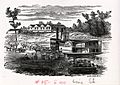
Drawing of ship at port 1859
-
Drawing of ship at port 1859
-

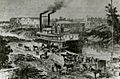
The Houston Ship Channel during its first opening in 1915
-

Houston Ship Channel and foot of Main Street, Houston, Texas (postcard, circa 1910)
-
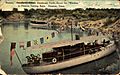
Yachts in the Houston Turning Basin, Houston (postcard, circa 1911)
-

Ship Turning Basin, Buffalo River, Houston (postcard, circa 1914-1924)
-
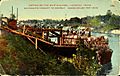
Cotton on the ship channel, Houston (circa, 1914)
-

Mosaic tile mural at the Houston Ship Channel Visitor's Center - 2016
-

Fireboat Howard T. Tellepsen in the Houston Channel (2006)


.jpg)


Images for kids
-
USS Texas museum is in the Houston Ship Channel

