Galveston Island facts for kids

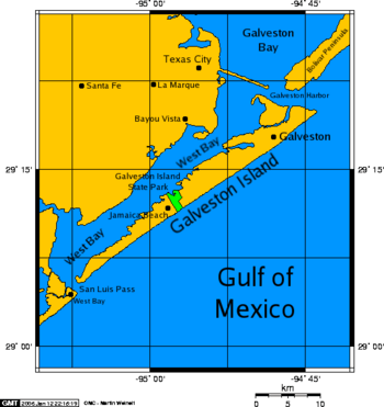
A map of Galveston Island, a barrier island on the Texas Gulf coast in the United States
|
|
| Geography | |
|---|---|
| Location | Gulf of Mexico |
| Coordinates | 29°13′20″N 94°54′32″W / 29.22222°N 94.90889°W |
| Archipelago | Texas barrier islands |
| Area | 66 sq mi (170 km2) |
| Length | 27 mi (43 km) |
| Width | 3 mi (5 km) |
| Highest point | 20 feet (6.1 m) |
| Administration | |
|
United States
|
|
| State | Texas |
| County | Galveston County |
| Largest settlement | Galveston (pop. 47,743) |
| Demographics | |
| Population | 48,726 (2010) |
| Pop. density | 342.21 /km2 (886.32 /sq mi) |
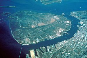
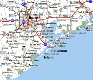
Galveston Island is a long, narrow piece of land on the Texas Gulf Coast in the United States. It's about 50 miles (80 km) southeast of Houston. Almost all of the island is part of the city of Galveston.
This island is about 27 miles (43 km) long and up to 3 miles (5 km) wide. It stretches from northeast to southwest. The Gulf of Mexico is to its east and south. West Bay is to the west, and Galveston Bay is to the north. The main way to reach the island from the mainland is by Interstate Highway 45. This highway crosses the Galveston Causeway, which goes over West Bay.
The very north end of the island is separated from the Bolivar Peninsula by Galveston Harbor. This harbor is the entrance to Galveston Bay. You can take a ferry between Galveston Island and the Bolivar Peninsula. The south end of the island is separated from the mainland by San Luis Pass. A toll bridge connects Galveston Island to the mainland at this point.
People who live on Galveston Island often describe themselves in two ways. If they were born on the island, they are called "BOI" (Born On Island). If they chose to move there, they are called "IBC" (Islander By Choice).
Contents
Learning on Galveston Island
Students living on Galveston Island attend Ball High School.
There are also several colleges and universities on the island:
- Galveston College (GC)
- Texas A&M University at Galveston (TAMUG)
- University of Texas Medical Branch (UTMB)
Galveston Island's Past
Early Inhabitants and Explorers
Long ago, Akokisa and Karankawa Native American groups lived and camped on Galveston Island. They likely used the island for fishing and hunting during different seasons.
Historians believe that Álvar Núñez Cabeza de Vaca and his small group stopped on the island in November 1528. This was during his famous journey of survival.
In 1816, Jao de la Porta and his brother Morin helped start the first European settlement on Galveston Island. Jao de la Porta was a trader from Portugal. He traded with the Karankawa people.
Pirates and Port Growth
The privateer Jean Lafitte brought his followers to the island. He named his settlement Campeche. For a few years, the island was their base for piracy and illegal trading. In 1821, the US Navy forced Lafitte to leave after he attacked an American ship.
After Mexico became independent in 1821, and then the Texas Revolution happened in 1836, more people moved to Texas. Galveston Island quickly became Texas' main port. It was a major place for immigrants to arrive. After Texas joined the United States in 1845, Galveston's population grew very fast. It became the biggest city in Texas for a while. Before the American Civil War, Galveston was the largest port in the world for shipping cotton. It was also the second-largest port for immigrants in the United States. Many Germans entered Texas through Galveston in the mid-1800s.
Civil War and Island Control
During the American Civil War, the Union army took control of Galveston Island for a few months in early 1863. However, Confederate forces, led by John B. Magruder, pushed them off the island. The Confederates then controlled Galveston for the rest of the war.

The Great Storm of 1900
On September 8, 1900, the worst natural disaster in United States history hit Galveston. The Galveston hurricane of 1900 came ashore that evening. It brought a huge storm surge that covered most of Galveston Island. Much of the city was destroyed. At least 6,000 people died in just a few hours.
Isaac M. Cline was the weather expert in Galveston. He knew a storm was in the Gulf. Even though September 7 was calm, Cline saw the rough seas getting worse. He sent a message to Washington, D.C., saying he thought much of the city would be underwater. He predicted many lives would be lost.
After the hurricane, the state and city built a seawall around the settled part of the island. Many houses were torn down, and new ones were built on stilts. Sand was pumped into the area behind the seawall. Over time, the eastern part of the island was raised by as much as 17 feet (5.2 meters).
More About Galveston Island
- Galveston Island from the Handbook of Texas Online
- Galveston Island State Park official website.
See also
 In Spanish: Isla de Galveston para niños
 | Shirley Ann Jackson |
 | Garett Morgan |
 | J. Ernest Wilkins Jr. |
 | Elijah McCoy |


