Galveston Causeway facts for kids
Quick facts for kids George & Cynthia Mitchell Memorial Causeway |
|
|---|---|

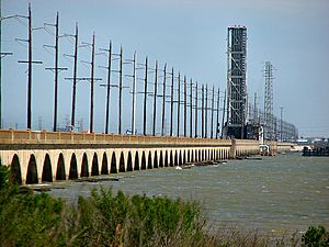
The old 1912 Galveston Causeway, now in use as a railroad bridge.
|
|
| Coordinates | 29°17′45″N 94°53′10″W / 29.2957°N 94.8861°W |
| Carries | Rail (old causeway) |
| Crosses | Gulf Intracoastal Waterway, Galveston Bay |
| Locale | Connects Galveston, Texas and Texas City, Texas, United States |
| Official name | George & Cynthia Mitchell Memorial Causeway |
| Maintained by | Texas Department of Transportation |
| History | |
| Engineering design by | Concrete Steel Engineering Co. |
| Constructed by | Penn Bridge Co. |
| Construction begin | 1912 |
| Opened | 1912 (original causeway) |
|
Galveston Causeway
|
|
| Area | 39 acres (16 ha) |
| NRHP reference No. | 76002028 |
| Significant dates | |
| Added to NRHP | December 12, 1976 |
| Lua error in Module:Location_map at line 420: attempt to index field 'wikibase' (a nil value). | |
The George & Cynthia Mitchell Memorial Causeway is a special kind of bridge in Galveston, Texas, United States. It's called a causeway because it's a raised road or railway built over water or wet ground. This causeway connects Galveston Island to the mainland.
It has two main parts. One part carries the busy Interstate 45 highway, with separate lanes for cars going north and south. The other part is the original causeway, built way back in 1912, which is now only used by trains. This causeway is super important because it's the main way for cars to get to Galveston Island. There's also another way to get there, called the Bolivar Ferry.
The causeway crosses over Galveston Bay and the Gulf Intracoastal Waterway. When it was first built in 1912, it carried both cars and trains. But in 1939, new causeways were built next to it for cars, so the old one became just for trains. Because it's so old and important, the original causeway was added to the National Register of Historic Places in 1976.
Building New Bridges (2003-2008)
Work began in 2003 to build brand new bridges for the car traffic. The new northbound bridge was finished in 2005. Building the southbound bridge started in 2006. However, a big storm called Hurricane Ike hit in 2008, which caused delays. The new southbound bridge was finally completed in November 2008.
Hurricane Ike's Impact (2008)
In September 2008, before Hurricane Ike even made landfall, the causeway was flooded. This happened because the storm was very wide and pushed a huge amount of water, called a storm surge, onto the land. Usually, a hurricane would cause the causeway to close because of strong winds before the water rises so much. After the hurricane hit, the causeway was blocked by many boats that had been washed ashore.
Upgrading the Railroad Bridge

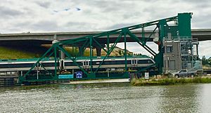
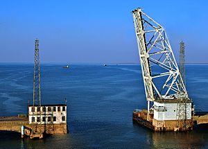
The original part of the causeway that carries trains used to have a special moving section called a bascule drawbridge. This type of bridge opens by lifting one end, like a seesaw. In 1987, the original bascule bridge was replaced with a newer, narrower one. This new bridge opened from the island side, not the mainland side. It also didn't have space for cars anymore.
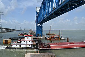
Then, in 2012, this bascule drawbridge was replaced again! This time, they put in a vertical-lift drawbridge. This type of bridge lifts straight up, like an elevator. This change was important because the old bridge's opening was only about 105 feet (32 meters) wide. The U.S. Coast Guard had said this narrow opening was dangerous for boats. The new vertical-lift bridge allowed the channel to be widened to about 300 feet (91 meters), making it much safer for ships and barges to pass through. The old bascule bridge was even sold and moved to California to be used on another railroad!
 | Frances Mary Albrier |
 | Whitney Young |
 | Muhammad Ali |


