Bolivar Peninsula, Texas facts for kids
Quick facts for kids
Bolivar Peninsula, Texas
|
|
|---|---|
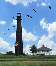
Point Bolivar Lighthouse
|
|
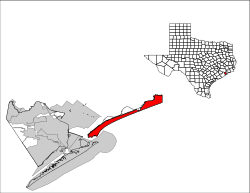
Location of Bolivar Peninsula, Texas
|
|
| Country | United States |
| State | Texas |
| County | Galveston |
| Area | |
| • Total | 48.1 sq mi (124.7 km2) |
| • Land | 42.5 sq mi (110.1 km2) |
| • Water | 5.6 sq mi (14.6 km2) |
| Elevation | 10 ft (3 m) |
| Population
(2020)
|
|
| • Total | 2,769 |
| • Density | 57.51/sq mi (22.205/km2) |
| Time zone | UTC-6 (Central (CST)) |
| • Summer (DST) | UTC-5 (CDT) |
| FIPS code | 48-09250 |
| GNIS feature ID | 1852688 |
Bolivar Peninsula is a narrow strip of land in Galveston County, Texas. It is a "census-designated place" (CDP). This means it's an area that the government counts as a community for population statistics. In 2020, about 2,769 people lived here.
Several smaller communities are part of Bolivar Peninsula. These include Port Bolivar, Crystal Beach, Caplen, Gilchrist, and High Island.
Contents
History of Bolivar Peninsula
The Bolivar Peninsula got its name in 1816. It was named after Simón Bolívar, a famous leader from Venezuela. He helped many countries in Latin America become independent.
In the early 1800s, pirates like Jean Laffite used the peninsula. It was part of their secret "kingdom" around Galveston Bay. The peninsula was also a path used to move enslaved people overland between Louisiana and Galveston.
James Long started an operation here in 1819. This was the first settlement on the peninsula. Fort Las Casas was built in 1820. Later, in 1838, Samuel D. Parr helped start the settlement that became Port Bolivar.
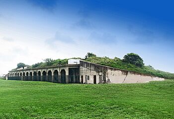
The Point Bolivar Lighthouse is an important landmark. It was built in 1872 and is now privately owned. It stands at the western end of the peninsula. Fort Travis in Bolivar Peninsula was built starting in 1898. It's different from the Fort Travis in Galveston.
Construction of the North Jetty began in 1874. This jetty extends from the peninsula into Galveston Bay. From 1896 to 1942, a railway connected Beaumont to Galveston Island. It used special train ferries to cross the water.
Long ago, people called the Bolivar Peninsula the "breadbasket of Galveston." It was also known as the "watermelon capital of Texas."
Crystal Beach was a town from 1971 to 1987. It has always been the most populated community on the peninsula. In 1991, the peninsula got an improved 9-1-1 emergency system. This system helps calls go to the right dispatchers and shows the caller's address.
The peninsula was hit hard by Hurricane Ike in 2008. The hurricane made landfall on September 13, 2008.
Geography of Bolivar Peninsula
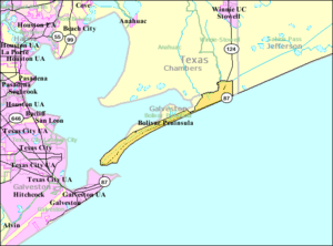
The Bolivar Peninsula is a very thin strip of land. It is located in Galveston County. It separates the eastern part of Galveston Bay from the Gulf of Mexico.
At its narrowest point, the peninsula is only about a quarter of a mile wide. This narrow spot is near Gilchrist. Here, the peninsula was once divided by a waterway called Rollover Pass.
The entire area of the CDP is about 124.7 square kilometers (48.1 square miles). Most of this is land, about 110.1 square kilometers (42.5 square miles). The rest, about 14.6 square kilometers (5.6 square miles), is water.
Population Information
The population of Bolivar Peninsula was 2,769 people in 2020. It's important to remember that the population numbers changed a lot after Hurricane Ike in September 2008.
The community is made up of people from many different backgrounds. In 2020, most residents were White. There were also people who identified as Black or African American, Native American, Asian, Pacific Islander, and those of mixed heritage. About 11.56% of the population was Hispanic or Latino.
Education
Students on the Bolivar Peninsula attend schools in two different districts. These are the Galveston Independent School District (GISD) and the High Island Independent School District (HIISD).
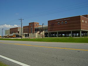
The western part of the peninsula, including Port Bolivar and Crystal Beach, is in the Galveston Independent School District. Students here go to Crenshaw Elementary and Middle School, which is on the peninsula. For high school, they attend Ball High School in Galveston. The current Crenshaw school building opened in 2005 in Crystal Beach. Before that, the school had two separate buildings in Port Bolivar. As of 2020, parents in GISD can choose which school their child attends. However, only Bolivar Peninsula residents get school bus service to Crenshaw K-8.
The eastern part of the peninsula, including Caplen, Gilchrist, and High Island, is served by the High Island Independent School District.
All students on the peninsula, regardless of their school district, can attend Galveston College in Galveston for higher education.
Parks and Recreation
The Galveston County Department of Parks and Senior Services manages local parks and community centers. They run the Joe Faggard Community Center in the Crystal Beach area. They also operate the Fort Travis Seashore Park.
The community celebrates Mardi Gras every year. A parade takes place along Texas State Highway 87. Many local groups, businesses, and even politicians take part in the celebration. It's described as a "small town parade."
Transportation
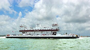
The Texas Department of Transportation offers a ferry service. This ferry connects Port Bolivar on the peninsula to Galveston.
During the quieter times of the year, ferries usually run every 30 minutes during the day. At night, they run about once an hour. During tourist season or on holidays, more ferries are added. They can run as often as every 15 minutes. There was a plan to build a bridge, the Bolivar Bridge, to connect the peninsula to Galveston Island, but this plan was canceled.
Highways
 SH 87
SH 87
Hurricane Ike's Impact
On September 13, 2008, Hurricane Ike hit the Texas coast. It was one of the largest hurricanes ever recorded in the North Atlantic. Its cloud mass covered almost the entire Gulf of Mexico. Experts measured Ike's total energy and found it was even greater than Hurricane Katrina in 2005.
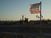
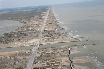
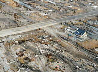
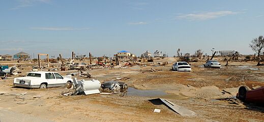
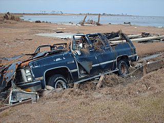
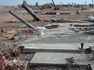
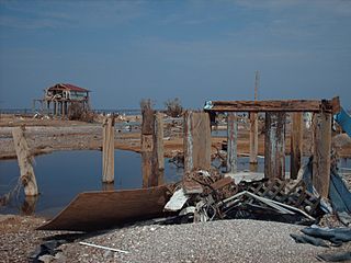
Hurricane Ike caused huge damage to the Bolivar Peninsula. It destroyed many buildings and changed the shoreline forever. Entire communities along the coast were wiped out by the storm's powerful surge. The peninsula is very low-lying, so it was especially vulnerable. Even though Ike was a strong Category 2 storm, its massive and long-lasting storm surge and waves devastated the area.
In Gilchrist, Texas, almost all buildings were knocked off their foundations. Many were completely destroyed or washed into nearby swamplands. The bridge at Rollover Pass was reduced to just one lane.
The Bolivar Peninsula was directly in the path of the strongest part of the hurricane. Winds blew strongly from the ocean towards the land. This pushed huge amounts of water inland. The storm surge reached up to 21 feet (6.4 meters). Most areas of the peninsula were covered by at least 5 feet (1.5 meters) of water. Many parts had at least 15 feet (4.6 meters) of water, not counting the waves.
After the storm, authorities reported that 3,600 structures on the peninsula were destroyed or badly damaged. That's 62% of all buildings. By January 2009, about 40% of the people who lived on the peninsula had returned. Gilchrist had the fewest people return.
Bolivar Peninsula after Ike
Religion
The Roman Catholic Archdiocese of Galveston-Houston has a church in Crystal Beach. It is called Our Lady By The Sea Chapel and Catholic Center. This church serves the entire peninsula. It is part of the Holy Family Parish, which also has churches on Galveston Island.
Before Hurricane Ike, there were other Catholic churches on the peninsula. Our Mother of Mercy Church in Port Bolivar was built around 1950. Crystal Beach also had St. Theresa of Liseaux Mission, built in 1994. St. Theresa was damaged by Hurricane Ike in 2008 and later torn down. Our Lady By The Sea was built on its site. Our Mother of Mercy was not damaged, but it was also closed and later demolished by the archdiocese.
After Hurricane Ike and before Our Lady By The Sea opened, people from Bolivar attended church in Galveston or Winnie. The new Our Lady church, which opened in 2010, brought together the communities from the two older churches.
See also
 In Spanish: Península Bolívar para niños
 | Aaron Henry |
 | T. R. M. Howard |
 | Jesse Jackson |


