
Anahuac, Texas facts for kids
Quick facts for kids
Anahuac, Texas
|
|
|---|---|

Entrance sign
|
|
| Country | United States |
| State | Texas |
| County | Chambers |
| Area | |
| • Total | 2.13 sq mi (5.51 km2) |
| • Land | 2.13 sq mi (5.51 km2) |
| • Water | 0.00 sq mi (0.00 km2) |
| Elevation | 20 ft (6 m) |
| Population
(2020)
|
|
| • Total | 1,980 |
| • Density | 1,100.19/sq mi (424.72/km2) |
| Time zone | UTC−6 (Central (CST)) |
| • Summer (DST) | UTC−5 (CDT) |
| ZIP Code |
77514
|
| Area code(s) | 409 |
| FIPS code | 48-03144 |
| GNIS feature ID | 2409705 |

Anahuac is a city in Texas, a state in the United States. It sits right on the coast of Trinity Bay. In 2020, about 1,980 people lived there. Anahuac is the main city, or seat, of Chambers County in Southeast Texas.
The Texas Legislature officially named Anahuac the "Alligator Capital of Texas" in 1989. The city even holds an annual alligator festival!
Contents
History of Anahuac, Texas
-
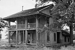
House of General Thomas Jefferson Chambers

The name Anahuac comes from the Nahuatl language, spoken by the Aztecs. It means "place beside the waters." The original Anáhuac was a valley in Mexico, but this city in Texas was never part of the Aztec Empire.
The first people to live here were the Atakapan and Caddo tribes. The first European settlers, the Burkhalter and Morehead families, arrived in 1715. They started a small village near what is now Lake Anahuac. In 1721, a French explorer named Jean Baptiste de La Harpe visited the area. Later, in the 1800s, the spot became known as "Perry's Point." This was named after Colonel Harry Perry, who set up a military camp there in 1816.
Events Leading to the Texas Revolution
Two important events in 1832 and 1835, called the Anahuac Disturbances, helped start the Texas Revolution. This revolution led to Texas becoming separate from Mexico. One event involved Mexican officials putting William Travis in jail. Another problem was unfair taxes on river trade for the settlers.
In October 1830, Mexican Colonel Juan Davis Bradburn set up a customs office on a bluff. This was the same spot where Perry had camped. Bradburn was told to name the new post Fort Anahuac. Soldiers built large kilns to make bricks for a stronger fort. However, after the Texas Revolution, locals used the bricks for their own homes. Today, no bricks from the fort remain.
By March 1831, Anahuac had 20 houses and seven stores. The town grew quickly because soldiers spent their pay there. By June 1, the town had over 300 civilians and 170 military members.
In 1862, during the American Civil War, a small Confederate army outpost was set up nearby.
Modern Anahuac Developments
The discovery of oil fields in 1935, like the Anahuac Oil Field, brought a time of growth. The Anahuac National Wildlife Refuge was created in 1963. It is about 16 miles southeast of the city.
In 1989, the local business group started the first Gatorfest. About 14,000 people came to this festival. It has been held every year since then and has grown a lot. In 2010, over 30,000 people attended the festival.
In 2019, a cargo plane, Atlas Air Flight 3591, crashed into Trinity Bay near Anahuac. The plane was flying for Amazon Air.
Geography and Location
Anahuac is located in the middle of Chambers County. It is at the northeast end of Trinity Bay and the south end of Lake Anahuac. The Trinity River flows into Trinity Bay just west of the city. Lake Anahuac was built in 1953 by the Burkhalter family. It holds a lot of water, about 33,348 acre-feet.
Texas State Highway 61 runs through Anahuac. It goes east and north for 12 miles to Interstate 10. From there, it's about 43 miles east to Houston and 40 miles southwest to Beaumont.
The city of Anahuac covers about 2.13 square miles (5.5 square kilometers) of land. There is no water within the city limits.
Anahuac is also planning a $50 million bond for school expansion. This is because many new homes and families are moving to the area. They expect about 1,000 more school-aged kids in the next five years.
Climate in Anahuac
| Climate data for Anahuac, Texas (1991–2020 normals, extremes 1931–2019) | |||||||||||||
|---|---|---|---|---|---|---|---|---|---|---|---|---|---|
| Month | Jan | Feb | Mar | Apr | May | Jun | Jul | Aug | Sep | Oct | Nov | Dec | Year |
| Record high °F (°C) | 92 (33) |
85 (29) |
93 (34) |
93 (34) |
97 (36) |
103 (39) |
106 (41) |
104 (40) |
105 (41) |
100 (38) |
89 (32) |
87 (31) |
106 (41) |
| Mean maximum °F (°C) | 75.7 (24.3) |
77.2 (25.1) |
81.1 (27.3) |
85.5 (29.7) |
91.0 (32.8) |
95.4 (35.2) |
96.6 (35.9) |
97.7 (36.5) |
95.2 (35.1) |
90.4 (32.4) |
83.7 (28.7) |
77.2 (25.1) |
98.7 (37.1) |
| Mean daily maximum °F (°C) | 61.6 (16.4) |
65.7 (18.7) |
71.3 (21.8) |
76.7 (24.8) |
83.2 (28.4) |
88.7 (31.5) |
90.7 (32.6) |
91.5 (33.1) |
87.5 (30.8) |
80.9 (27.2) |
71.5 (21.9) |
63.8 (17.7) |
77.8 (25.4) |
| Daily mean °F (°C) | 52.4 (11.3) |
56.2 (13.4) |
62.1 (16.7) |
67.8 (19.9) |
74.9 (23.8) |
80.8 (27.1) |
82.9 (28.3) |
82.9 (28.3) |
78.7 (25.9) |
70.5 (21.4) |
61.1 (16.2) |
54.2 (12.3) |
68.7 (20.4) |
| Mean daily minimum °F (°C) | 43.2 (6.2) |
46.8 (8.2) |
52.9 (11.6) |
58.9 (14.9) |
66.6 (19.2) |
72.8 (22.7) |
75.1 (23.9) |
74.4 (23.6) |
69.8 (21.0) |
60.1 (15.6) |
50.8 (10.4) |
44.5 (6.9) |
59.7 (15.4) |
| Mean minimum °F (°C) | 27.5 (−2.5) |
30.3 (−0.9) |
35.0 (1.7) |
43.2 (6.2) |
54.4 (12.4) |
64.7 (18.2) |
68.9 (20.5) |
67.7 (19.8) |
56.6 (13.7) |
44.0 (6.7) |
34.4 (1.3) |
27.6 (−2.4) |
23.4 (−4.8) |
| Record low °F (°C) | 11 (−12) |
12 (−11) |
23 (−5) |
34 (1) |
43 (6) |
49 (9) |
60 (16) |
60 (16) |
45 (7) |
33 (1) |
23 (−5) |
8 (−13) |
8 (−13) |
| Average precipitation inches (mm) | 4.59 (117) |
3.07 (78) |
3.63 (92) |
4.41 (112) |
5.39 (137) |
5.84 (148) |
5.68 (144) |
7.02 (178) |
7.02 (178) |
4.75 (121) |
3.85 (98) |
4.47 (114) |
59.72 (1,517) |
| Average snowfall inches (cm) | 0.0 (0.0) |
0.0 (0.0) |
0.0 (0.0) |
0.0 (0.0) |
0.0 (0.0) |
0.0 (0.0) |
0.0 (0.0) |
0.0 (0.0) |
0.0 (0.0) |
0.0 (0.0) |
0.0 (0.0) |
0.2 (0.51) |
0.2 (0.51) |
| Average precipitation days (≥ 0.01 in) | 8.5 | 7.9 | 7.8 | 6.0 | 6.2 | 9.0 | 8.7 | 9.2 | 8.6 | 5.5 | 6.4 | 8.6 | 92.4 |
| Average snowy days (≥ 0.1 in) | 0.0 | 0.0 | 0.0 | 0.0 | 0.0 | 0.0 | 0.0 | 0.0 | 0.0 | 0.0 | 0.0 | 0.0 | 0.0 |
| Source: NOAA (mean maxima/minima 1981–2010) | |||||||||||||
Wildlife and Nature

The Anahuac National Wildlife Refuge is located southeast of the city. It's a great place for birdwatching. Almost 250 different kinds of birds have been seen there! The refuge is home to many marsh birds, like the yellow rail and black rail.
People of Anahuac: Demographics
| Historical population | |||
|---|---|---|---|
| Census | Pop. | %± | |
| 1950 | 1,284 | — | |
| 1960 | 1,985 | 54.6% | |
| 1970 | 1,881 | −5.2% | |
| 1980 | 1,840 | −2.2% | |
| 1990 | 1,993 | 8.3% | |
| 2000 | 2,210 | 10.9% | |
| 2010 | 2,243 | 1.5% | |
| 2020 | 1,980 | −11.7% | |
| U.S. Decennial Census 1850–1900 1910 1920 1930 1940 1950 1960 1970 1980 1990 2000 2010 |
|||
| Race | Number | Percentage |
|---|---|---|
| White (NH) | 1,071 | 54.09% |
| Black or African American (NH) | 329 | 16.62% |
| Native American or Alaska Native (NH) | 9 | 0.45% |
| Asian (NH) | 16 | 0.81% |
| Some Other Race (NH) | 12 | 0.61% |
| Mixed/Multi-Racial (NH) | 73 | 3.69% |
| Hispanic or Latino | 470 | 23.74% |
| Total | 1,980 |
In 2020, there were 1,980 people living in Anahuac. They lived in 837 households, and 539 of these were families.
Back in 2000, there were 2,210 people in the city. About 38% of households had children under 18. Most households (55%) were married couples living together. The average household had about 2.69 people.
The median age in the city was 34 years old. This means half the people were younger than 34, and half were older. For every 100 females, there were about 88 males.
The average income for a household in 2000 was $40,924. For families, it was $46,750. About 13.5% of the population lived below the poverty line.
Transportation in Anahuac
The Chambers County Airport is located east of Anahuac. It helps serve the city and the surrounding area.
Media and News
The Progress is the local newspaper for Anahuac. It has been around for about 100 years. The Houston Chronicle is a larger newspaper that serves the wider Greater Houston area.
Education in Anahuac

The Anahuac Independent School District provides education for the community. Anahuac High School is the local high school.
The Chambers County Library in Anahuac is part of the Chambers County Library System. You can find it at 202 Cummings Street, Anahuac, Texas 77514.
Students living in the Anahuac Independent School District can attend Lee College.
See also
 In Spanish: Anáhuac (Texas) para niños
