Tyler County, Texas facts for kids
Quick facts for kids
Tyler County
|
|
|---|---|

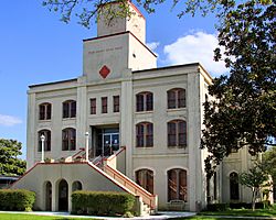
The Tyler County Courthouse in Woodville
|
|

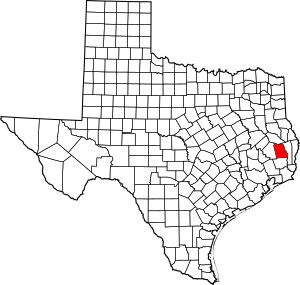
Location within the U.S. state of Texas
|
|
 Texas's location within the U.S. |
|
| Country | |
| State | |
| Founded | 1846 |
| Named for | John Tyler |
| Seat | Woodville |
| Largest town | Woodville |
| Area | |
| • Total | 936 sq mi (2,420 km2) |
| • Land | 925 sq mi (2,400 km2) |
| • Water | 11 sq mi (30 km2) 1.2% |
| Population
(2020)
|
|
| • Total | 19,798 |
| • Density | 21/sq mi (8/km2) |
| Time zone | UTC−6 (Central) |
| • Summer (DST) | UTC−5 (CDT) |
| Congressional district | 36th |
Tyler County is a place in the U.S. state of Texas. It's located in a part of Texas called East Texas. The main town, or county seat, is Woodville. In 2020, about 19,798 people lived there. Tyler County got its name from John Tyler, who was the 10th President of the United States. It's important to know that the city of Tyler, Texas is not in Tyler County. That city is about 140 miles north in Smith County.

Contents
About Tyler County's Land
According to the U.S. Census Bureau, Tyler County covers a total area of 936 square miles. Most of this area, 925 square miles, is land. The remaining 11 square miles, which is about 1.2%, is covered by water.
Main Roads in Tyler County
These are some of the important roads that go through Tyler County:
Neighboring Counties
Tyler County shares its borders with these other counties:
- Angelina County (to the north)
- Jasper County (to the east)
- Hardin County (to the south)
- Polk County (to the west)
Protected Natural Areas
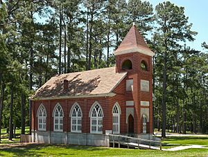
Part of the Big Thicket National Preserve is located within Tyler County. This preserve helps protect a unique natural area.
People of Tyler County
The population of Tyler County has changed over the years. You can see how many people have lived here in different census years:
| Historical population | |||
|---|---|---|---|
| Census | Pop. | %± | |
| 1850 | 1,894 | — | |
| 1860 | 4,525 | 138.9% | |
| 1870 | 5,010 | 10.7% | |
| 1880 | 5,825 | 16.3% | |
| 1890 | 10,877 | 86.7% | |
| 1900 | 11,899 | 9.4% | |
| 1910 | 10,250 | −13.9% | |
| 1920 | 10,415 | 1.6% | |
| 1930 | 11,448 | 9.9% | |
| 1940 | 11,948 | 4.4% | |
| 1950 | 11,292 | −5.5% | |
| 1960 | 10,666 | −5.5% | |
| 1970 | 12,417 | 16.4% | |
| 1980 | 16,223 | 30.7% | |
| 1990 | 16,646 | 2.6% | |
| 2000 | 20,871 | 25.4% | |
| 2010 | 21,766 | 4.3% | |
| 2020 | 19,798 | −9.0% | |
| U.S. Decennial Census 1850–2010 2010 2020 |
|||
| Race / Ethnicity (NH = Non-Hispanic) | Pop 2000 | Pop 2010 | Pop 2020 | % 2000 | % 2010 | % 2020 |
|---|---|---|---|---|---|---|
| White alone (NH) | 17,290 | 17,507 | 15,302 | 82.84% | 80.43% | 77.29% |
| Black or African American alone (NH) | 2,491 | 2,376 | 2,040 | 11.94% | 10.92% | 10.30% |
| Native American or Alaska Native alone (NH) | 87 | 104 | 111 | 0.42% | 0.48% | 0.56% |
| Asian alone (NH) | 41 | 49 | 97 | 0.20% | 0.23% | 0.49% |
| Pacific Islander alone (NH) | 4 | 6 | 3 | 0.02% | 0.03% | 0.02% |
| Other Race alone (NH) | 17 | 19 | 47 | 0.08% | 0.09% | 0.24% |
| Mixed Race or Multiracial (NH) | 199 | 218 | 678 | 0.95% | 1.00% | 3.42% |
| Hispanic or Latino (any race) | 742 | 1,487 | 1,520 | 3.56% | 6.83% | 7.68% |
| Total | 20,871 | 21,766 | 19,798 | 100.00% | 100.00% | 100.00% |
In 2000, there were 20,871 people living in Tyler County. There were 7,775 households, which are groups of people living together in one home. About 29.7% of these households had children under 18 living with them. The average household had 2.5 people.
The population was spread out by age. About 23.2% of the people were under 18 years old. About 17.8% were 65 years or older. The average age in the county was 39 years old.
Towns and Communities
Tyler County has several towns and communities where people live.
Cities in Tyler County
- Colmesneil
- Ivanhoe
- Woodville (This is the county seat, the main town for county government.)
Towns in Tyler County
Census-Designated Places (CDPs)
These are areas that are like towns but are not officially incorporated as cities or towns.
Unincorporated Areas
These are smaller communities that are not part of any city or town.
Schools and Learning
Tyler County has several school districts that serve the students living there.
- Chester Independent School District
- Colmesneil Independent School District
- Spurger Independent School District
- Warren Independent School District
- Woodville Independent School District
For students who want to continue their education after high school, the county is also served by Angelina College.
See also
 In Spanish: Condado de Tyler (Texas) para niños
 | Bessie Coleman |
 | Spann Watson |
 | Jill E. Brown |
 | Sherman W. White |

