Jasper County, Texas facts for kids
Quick facts for kids
Jasper County
|
|
|---|---|

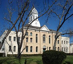
Jasper County Courthouse
|
|

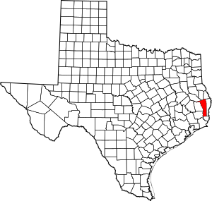
Location within the U.S. state of Texas
|
|
 Texas's location within the U.S. |
|
| Country | |
| State | |
| Founded | 1837 |
| Named for | William Jasper |
| Seat | Jasper |
| Largest city | Jasper |
| Area | |
| • Total | 970 sq mi (2,500 km2) |
| • Land | 939 sq mi (2,430 km2) |
| • Water | 31 sq mi (80 km2) 3.2%% |
| Population
(2020)
|
|
| • Total | 32,980 |
| • Density | 34.00/sq mi (13.13/km2) |
| Time zone | UTC−6 (Central) |
| • Summer (DST) | UTC−5 (CDT) |
| Congressional district | 36th |
Jasper County is a place in the state of Texas, USA. In 2020, about 32,980 people lived there. The main town, or 'county seat,' is called Jasper.
This area became a county in Texas in 1837. It is named after William Jasper, a hero from the American Revolutionary War.
Contents
Geography of Jasper County
Jasper County covers a total area of about 970 square miles. Most of this (939 square miles) is land. The rest (31 square miles, or 3.2%) is water.
Main Roads and Highways
These are the major roads that pass through Jasper County:
 U.S. Highway 69
 U.S. Highway 96
 U.S. Highway 190
 State Highway 62
 State Highway 63
 Recreational Road 255
Neighboring Counties
Jasper County shares borders with these other counties:
- San Augustine County (to the north)
- Sabine County (to the northeast)
- Newton County (to the east)
- Orange County (to the south)
- Hardin County (to the southwest)
- Tyler County (to the west)
- Angelina County (to the northwest)
Protected Natural Areas
Parts of these national protected areas are found in Jasper County:
- Angelina National Forest
- Big Thicket National Preserve
- Sabine National Forest
People of Jasper County
The population of Jasper County has changed over the years. Here's how many people have lived there during different census years:
| Historical population | |||
|---|---|---|---|
| Census | Pop. | %± | |
| 1850 | 1,767 | — | |
| 1860 | 4,037 | 128.5% | |
| 1870 | 4,218 | 4.5% | |
| 1880 | 5,779 | 37.0% | |
| 1890 | 5,592 | −3.2% | |
| 1900 | 7,138 | 27.6% | |
| 1910 | 14,000 | 96.1% | |
| 1920 | 15,569 | 11.2% | |
| 1930 | 17,064 | 9.6% | |
| 1940 | 17,491 | 2.5% | |
| 1950 | 20,049 | 14.6% | |
| 1960 | 22,100 | 10.2% | |
| 1970 | 24,692 | 11.7% | |
| 1980 | 30,781 | 24.7% | |
| 1990 | 31,102 | 1.0% | |
| 2000 | 35,604 | 14.5% | |
| 2010 | 35,710 | 0.3% | |
| 2020 | 32,980 | −7.6% | |
| U.S. Decennial Census 1850–2010 2010–2020 |
|||
In 2000, there were 35,604 people living in the county. About 13,450 households were counted. The average number of people per household was 2.58.
The population was made up of different age groups. About 26.5% of the people were under 18 years old. Around 15.3% were 65 years or older. The average age in the county was 37 years.
Towns and Communities
Here are the different types of communities in Jasper County:
Cities
- Browndell
- Jasper (This is the county seat, the main administrative town)
- Kirbyville
Census-Designated Places (CDPs)
These are areas that are like towns but are not officially incorporated as cities:
Unincorporated Communities
These are smaller communities that are not part of any city or CDP:
- Beans
- Beech Grove
- Bessmay
- Brookeland (partly in Sabine County)
- Erin
- Gist
Ghost Towns
- Zeirath (This is a town that no longer exists or has very few residents)
Education in Jasper County
Students in Jasper County attend schools in various school districts:
- Brookeland Independent School District
- Buna Independent School District
- Colmesneil Independent School District
- Evadale Independent School District
- Jasper Independent School District
- Kirbyville Consolidated Independent School District
- Vidor Independent School District
For higher education, some parts of Jasper County are served by Angelina College.
See also
 In Spanish: Condado de Jasper (Texas) para niños
 | Frances Mary Albrier |
 | Whitney Young |
 | Muhammad Ali |

