Sabine County, Texas facts for kids
Quick facts for kids
Sabine County
|
|
|---|---|

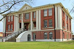
The Sabine County Courthouse
|
|

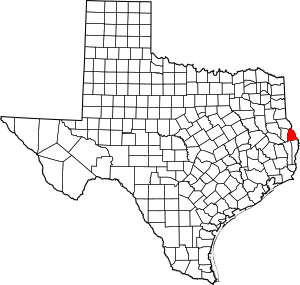
Location within the U.S. state of Texas
|
|
 Texas's location within the U.S. |
|
| Country | |
| State | |
| Founded | 1837 |
| Named for | Sabine River |
| Seat | Hemphill |
| Largest city | Milam |
| Area | |
| • Total | 577 sq mi (1,490 km2) |
| • Land | 491 sq mi (1,270 km2) |
| • Water | 85 sq mi (220 km2) 15%% |
| Population
(2020)
|
|
| • Total | 9,894 |
| • Estimate
(2022)
|
10,048 |
| • Density | 17.147/sq mi (6.621/km2) |
| Time zone | UTC−6 (Central) |
| • Summer (DST) | UTC−5 (CDT) |
| Congressional district | 1st |
Sabine County is a county located in the eastern part of Texas. It sits right on the border with the state of Louisiana.
In 2020, about 9,894 people lived here. The county was created on December 14, 1837. It got its name from the Sabine River, which forms its eastern edge.
Contents
Exploring Sabine County's Land
Sabine County covers a total area of about 577 square miles. Most of this area, about 491 square miles, is land. The rest, about 85 square miles, is water. This means about 15% of the county is covered by water.
Main Roads in Sabine County
Several important highways run through Sabine County, helping people travel around.
Protected Natural Areas
Part of the Sabine National Forest is located within Sabine County. This is a large area of protected land. It is important for nature and wildlife.
Neighboring Areas
Sabine County shares its borders with several other counties and one parish.
- To the north: Shelby County
- To the east: Sabine Parish, Louisiana
- To the south: Newton County
- To the southwest: Jasper County
- To the west: San Augustine County
Sabine County's Past
Like other areas in eastern Texas, Sabine County was once home to large farms called plantations. These farms grew cotton. They relied on the hard work of many enslaved African Americans.
After the Civil War, slavery ended. Many formerly enslaved people, known as freedmen, stayed in the area. They often worked as tenant farmers or sharecroppers. This meant they farmed land owned by others and shared their crops.
From the 1930s to the 1970s, the number of people living in Sabine County went down. Many African Americans moved away from this rural area. This was part of a big movement called the Great Migration. People left the South to find better jobs and escape unfair rules. These rules were known as Jim Crow laws. They also sought new opportunities in cities in the North and on the West Coast.
Population Changes Over Time
The number of people living in Sabine County has changed a lot over the years. Here's how the population has grown and shrunk since 1850:
| Historical population | |||
|---|---|---|---|
| Census | Pop. | %± | |
| 1850 | 2,498 | — | |
| 1860 | 2,750 | 10.1% | |
| 1870 | 3,256 | 18.4% | |
| 1880 | 4,161 | 27.8% | |
| 1890 | 4,969 | 19.4% | |
| 1900 | 6,394 | 28.7% | |
| 1910 | 8,582 | 34.2% | |
| 1920 | 12,299 | 43.3% | |
| 1930 | 11,998 | −2.4% | |
| 1940 | 10,896 | −9.2% | |
| 1950 | 8,568 | −21.4% | |
| 1960 | 7,302 | −14.8% | |
| 1970 | 7,187 | −1.6% | |
| 1980 | 8,702 | 21.1% | |
| 1990 | 9,586 | 10.2% | |
| 2000 | 10,469 | 9.2% | |
| 2010 | 10,834 | 3.5% | |
| 2020 | 9,894 | −8.7% | |
| 2022 (est.) | 10,048 | −7.3% | |
| U.S. Decennial Census 1850–2010 2010-2020 |
|||
Learning in Sabine County
Several school districts serve the children of Sabine County.
- Brookeland Independent School District (part of it)
- Hemphill Independent School District
- Shelbyville Independent School District (part of it)
- West Sabine Independent School District
For students who want to go to college, the county is served by Angelina College.
Towns and Communities
Sabine County has a few towns and many smaller communities.
Cities
Unincorporated Areas
These are areas that are not part of an official city or town.
Census-designated Places
Other Communities
- Bronson
- Brookeland (partly in Jasper County)
- Fairmount
- Geneva
- Isla
- Pendleton Harbor
- Rosevine
- Sexton
- Yellowpine
Past Communities
Some communities in Sabine County no longer exist or are very small today.
- Bayou
- East Mayfield
- Fairdale
- Gravehill
- Pendleton
- Plainview
- Sabinetown
- Tebo
- Time
- Vesta
See also
 In Spanish: Condado de Sabine para niños
 | John T. Biggers |
 | Thomas Blackshear |
 | Mark Bradford |
 | Beverly Buchanan |

