Sabine Parish, Louisiana facts for kids
Quick facts for kids
Sabine Parish, Louisiana
|
|
|---|---|
| Parish of Sabine | |

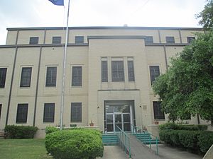
Sabine Parish Courthouse in Many
|
|

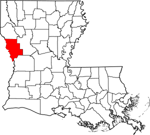
Location within the U.S. state of Louisiana
|
|

Louisiana's location within the U.S.
|
|
| Country | |
| State | |
| Region | Central Louisiana |
| Founded | March 27, 1843 |
| Named for | Sabine River and Sabine Free State |
| Parish seat (and largest town) | Many |
| Incorporated municipalities |
7 (total)
2 towns and 5 villages
(located entirely or partially within parish boundaries) |
| Area | |
| • Total | 2,620 km2 (1,012 sq mi) |
| • Land | 2,250 km2 (867 sq mi) |
| • Water | 380 km2 (145 sq mi) |
| • percentage | 40 km2 (14 sq mi) |
| Population
(2020)
|
|
| • Total | 22,155 |
| • Density | 8.453/km2 (21.892/sq mi) |
| Time zone | UTC-6 (CST) |
| • Summer (DST) | UTC-5 (CDT) |
| Area code | 318 |
| Congressional district | 4th |

Sabine Parish (in French: Paroisse de la Sabine) is a special area in Louisiana, a U.S. state. It is called a parish instead of a county. In 2020, about 22,155 people lived here. The main town and biggest place is Many.
Sabine Parish was created on March 27, 1843. It was one of five parishes made by the Louisiana State Legislature in just five weeks. It was formed from Natchitoches Parish. The Sabine River became its western border. This river was also the international boundary between the United States and the Republic of Texas at that time.
Contents
Exploring Sabine Parish History
The Neutral Strip: A Unique Border Area
The land that is now Sabine Parish was first home to the Adais (Brushwood) Indians. They were part of the Caddo Confederacy. Over time, different countries ruled this area. It was Spanish, then French, then English, then Spanish again, and finally French. In 1803, Napoleon sold it to the United States as part of the Louisiana Purchase.
After the purchase, the United States and Spain disagreed about the border. The U.S. said the Sabine River was the border. Spain claimed a line further east in Louisiana. In 1806, they signed the Neutral Ground Treaty. This made the area a "Sabine Free State," a neutral zone. It became a place where outlaws and adventurers could hide.
This neutral strip stretched from the Sabine River east to other rivers and bayous. Both countries claimed the land but neither controlled it. English-speaking settlers from older states started moving into this area. They settled on Spanish land grants. One early settler was Thomas Arthur, who claimed land on Negreet Creek.
In 1819, Spain gave up its claims to land east of the Sabine River. The United States then took control to bring law and order. Many people moved into what is now Sabine Parish. Small towns began to appear. Negreet was founded in 1822. Other early settlements included Toro (1827) and Noble (1830s).
Fort Jesup was built in 1822 by Lieutenant Colonel Zachary Taylor. He later became the 12th President of the United States. His soldiers helped bring order to the Neutral Ground. Fort Jesup was an important frontier post until Texas joined the U.S. in 1845. Today, visitors can still explore this historic site.
Two main roads crossed the Neutral Strip near Many. The San Antonio Trace and El Camino Real went from Natchitoches Parish west into East Texas. Many farmers and villages grew along El Camino Real.
How Sabine Parish Was Formed
Sabine Parish was created when America was entering a new time of growth. In 1831, a government survey divided the Sabine area into sections. Also, Henry Miller Shreve cleared the Red River in 1838. This opened the Red River to steamboats and encouraged more people to settle.
Steamboats began using the Sabine River in 1830. By 1850, there was a lot of boat traffic. Popular stops were Columbus, East Pendleton, and Carter's Ferry. Sabine Town, a busy river port, was about 3 miles (4.8 km) south of Pendleton. Many settlers arrived just before the American Civil War.
The state legislature created Sabine Parish on March 7, 1843. It was formed from Natchitoches Parish. Since Texas was an independent country, the Sabine River was an international border.
Less than a month later, Sabine Parish gained more land. This happened when the borders of its northern neighbor, DeSoto Parish, were set. In 1854, half a township from Natchitoches was added. In 1871, a large part of southern Sabine Parish was used to create Vernon Parish. Since then, the parish borders have stayed the same.
The law that created the parish said its main town should be named Many. This was to honor Colonel John B. Many, who was in charge at Fort Jesup. Fort Jesup was the most important settlement in the parish at the time. Many was on the road that went into Texas.
On May 17, 1843, Judge W. R. D. Speight and others bought 40 acres (0.16 km2) of land for Sabine Parish. Citizens asked the police jury to plan the town on this land. They wanted to sell lots and build public buildings. The police jury planned a courthouse and jail. They raised money by selling the land lots.
John Baldwin built the first house in Many. He ran a store and used his home as a tavern. He was also the first postmaster. Williams Mains was the first settler in the area, arriving in 1830. The first cotton gin was built in the early 1850s. The first census showed Sabine had 3,347 white people and 1,168 enslaved people.
The Civil War and Railroads
Sabine Parish was the site of the last major battle in Louisiana. This battle was fought on April 9, 1864, near old Pleasant Hill. It happened the day after the Confederate victory at Mansfield. This battle made Federal troops retreat along the road between Shreveport and Natchitoches.
These battles were very important. They stopped Union forces from capturing Shreveport. This also prevented Texas from being cut off from the rest of the Confederacy.
After the war, railroads became more important than steamboats. The Texas-Pacific line was finished in 1882. It connected Shreveport and New Orleans. The town of Pleasant Hill moved from DeSoto Parish to be closer to the railroad in Sabine Parish. The Kansas City Southern Railroad was built through the parish in 1896. This led to the creation of towns like Converse, Zwolle, Fisher, and Florien.
The area was mostly farming land. But the railroads brought lumbermen. They built sawmills to cut down the many trees. These trees were longleaf virgin pine, used for building all over the world. After about 30 years, many forests were gone. Many sawmills, like Gandy and Peason, moved away.
In the early 1940s, people started replanting trees. Pulp and paper mills bought the smaller trees. Later, Southern Pine plywood was developed. Vancouver Plywood, Inc., the first plywood mill in Louisiana, opened in Florien.
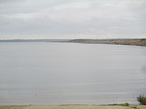
Reforestation also led to the creation of Hodges Gardens in the 1950s. This brought a new industry: tourism. Tourism grew even more when the Toledo Bend Reservoir was finished in 1968.
World War II and Military Training
The largest military training exercises ever held in the United States took place in and around Sabine Parish in May 1940. These army exercises in the Sabine River area showed how close the possibility of war was. About 40,000 soldiers from the Blue Army defended the Sabine River. They were fighting against 30,000 invading Red troops.
Soldiers from 33 states took part in these exercises. They covered 10,000 square miles (25,900 km2) of forests, hills, rivers, and valleys. This area was between Alexandria and Nacogdoches, Texas.
Many important military leaders passed through the area during these maneuvers. These included Lieutenant General Ben Lear, Colonel Dwight D. Eisenhower, Lieutenant General Walter Krueger, and Brigadier General George S. Patton, Jr.
Oil was discovered in 1928. Crude oil and natural gas became important natural resources, along with timber. However, oil production slowed down around 1934. Oil became a major economic factor again in the 1950s when new oil reserves were found near Many. Sabine Parish has about 1,008 square miles (2,611 km2) of land. It has some of the best timber in the world and other natural resources.
Recent Events in Sabine Parish
In 2014, a legal case was brought against the Sabine Parish School Board. The case involved concerns about how the school district handled religious freedom for students. The court quickly made a decision in the case.
Sabine Parish Geography
The U.S. Census Bureau says that Sabine Parish covers about 1,012 square miles (2,621 km2) in total. About 867 square miles (2,245 km2) of this is land. The other 145 square miles (376 km2), or 14%, is water.
Main Roads in Sabine Parish
 U.S. Highway 171
 Louisiana Highway 6
 Louisiana Highway 118
 Louisiana Highway 174
 Louisiana Highway 191
Neighboring Parishes and Counties
- De Soto Parish (north)
- Natchitoches Parish (east)
- Vernon Parish (southeast)
- Newton County, Texas (southwest)
- Sabine County, Texas (west)
- Shelby County, Texas (northwest)
Sabine Parish Population Changes
| Historical population | |||
|---|---|---|---|
| Census | Pop. | %± | |
| 1850 | 4,515 | — | |
| 1860 | 5,828 | 29.1% | |
| 1870 | 6,456 | 10.8% | |
| 1880 | 7,344 | 13.8% | |
| 1890 | 9,390 | 27.9% | |
| 1900 | 15,421 | 64.2% | |
| 1910 | 19,874 | 28.9% | |
| 1920 | 20,713 | 4.2% | |
| 1930 | 24,110 | 16.4% | |
| 1940 | 23,586 | −2.2% | |
| 1950 | 20,880 | −11.5% | |
| 1960 | 18,564 | −11.1% | |
| 1970 | 18,638 | 0.4% | |
| 1980 | 25,280 | 35.6% | |
| 1990 | 22,646 | −10.4% | |
| 2000 | 23,459 | 3.6% | |
| 2010 | 24,233 | 3.3% | |
| 2020 | 22,155 | −8.6% | |
| U.S. Decennial Census 1790-1960 1900-1990 1990-2000 2010 |
|||
Population in 2020
| Race | Number | Percentage |
|---|---|---|
| White (not Hispanic) | 14,850 | 67.03% |
| Black or African American (not Hispanic) | 3,520 | 15.89% |
| Native American | 1,790 | 8.08% |
| Asian | 63 | 0.28% |
| Pacific Islander | 12 | 0.05% |
| Other/Mixed | 1,210 | 5.46% |
| Hispanic or Latino | 710 | 3.2% |
In 2020, the 2020 United States census showed that 22,155 people lived in Sabine Parish. There were 9,158 households and 6,057 families.
Population in 2010
According to the 2010 United States Census, there were 24,233 people living in the parish.
- 70.8% were White
- 16.6% were Black or African American
- 8.6% were Native American
- 0.2% were Asian
- 0.4% were of some other race
- 3.4% were of two or more races
- 3.4% were Hispanic or Latino (of any race).
Education in Sabine Parish
Public schools in Sabine Parish are run by the Sabine Parish School Board. The area is also served by Bossier Parish Community College.
Communities in Sabine Parish
Towns
Villages
Unincorporated Areas
These are places that are not officially towns or villages.
Census-designated places
Other communities
Local Services
- Sabine Medical Center is the hospital in the parish.
Historic Places to Visit
- You can find a list of important historic places in Sabine Parish at National Register of Historic Places listings in Sabine Parish, Louisiana.
See also
 In Spanish: Parroquia de Sabine para niños
 | Jackie Robinson |
 | Jack Johnson |
 | Althea Gibson |
 | Arthur Ashe |
 | Muhammad Ali |

