
Neutral Ground (Louisiana) facts for kids

The Neutral Ground was a special area between Spanish Texas and the United States' new Louisiana Purchase. It was also called the Neutral Strip or Neutral Territory. From 1806 to 1821, this land in what is now western Louisiana didn't officially belong to either Spain or the United States. Leaders from both countries agreed to leave it alone for a while.
Contents
Why Was the Neutral Ground Created?
For many years, Spain worried about France moving into its territory from Louisiana. Around 1734, the French moved their fort at Natchitoches across the Red River. Spain saw this as taking their land. Spanish governors in Texas were told to investigate these moves.
In 1753, the Spanish governor of Texas, Jacinto de Barrios y Jáuregui, found that the French had moved into Texas. They were west of a small creek called Arroyo Hondo. This creek had been the border between French and Spanish lands.
How Louisiana Changed Hands
In 1764, France gave its Louisiana colony to Spain. This huge area was west of the Mississippi River. Since both Louisiana and Texas were now Spanish, the border problem didn't seem important anymore. Spain managed this land from Havana, Cuba. They let people from many countries live there if they promised to be loyal to Spain and worship as Catholics. Many Americans moved in, hoping to get land grants.
But then, in 1800, Spain secretly gave Louisiana back to France. The agreement didn't say exactly where the borders of Louisiana were. When U.S. President Thomas Jefferson heard about this, he wanted to buy land near the Mississippi River. He wanted to make sure Americans could still use the river to reach the Gulf of Mexico.
Jefferson found out that Napoleon, the leader of France, was willing to sell all of Louisiana. Napoleon needed money for his wars in Europe. France officially took control of Louisiana from Spain in November 1803. Then, they quickly sold it to the United States in December 1803. This deal, called the Louisiana Purchase, made the United States twice as big! It opened up new areas for Americans to move west.
The Border Problem Begins
After the Louisiana Purchase, the exact borders of the land were still unclear. The United States claimed the same borders that France had claimed before giving Louisiana to Spain. The U.S. even said its land went all the way to the Rio Grande river, based on an old French settlement from 1684.
However, the main U.S. claim was that the Sabine River was the western border. Today, the Sabine River is the border between Louisiana and Texas. Spain still claimed the Arroyo Hondo as its eastern border. South of the Kisatchie Hills, Spain claimed the Calcasieu River as its border.
Negotiations to fix the border problem stopped in 1805. Spain and the United States stopped talking to each other. For a whole year, from October 1805 to October 1806, there were small fights and arguments near the Sabine River. People heard rumors that both sides were gathering soldiers.
Creating the Neutral Ground
Neither Spain nor the United States wanted a big war over this land. To stop the fighting, two military leaders met. U.S. General James Wilkinson and Spanish Lt. Col. Simón de Herrera signed an agreement. On November 5, 1806, they declared the disputed land the Neutral Ground. They agreed to leave it alone until their governments could decide on the border.
This agreement wasn't a formal treaty, and neither government officially approved it. But both sides mostly respected it. Even with this agreement, the exact borders of the Neutral Ground were still a bit fuzzy.
The Arroyo Hondo and the Calcasieu River were the eastern border. The Sabine River was the western border. The Gulf of Mexico was the southern border. The northern border was probably around the thirty-second parallel.
The Neutral Ground included parts of several parishes in Louisiana today. These include De Soto, Sabine, Natchitoches, Vernon, Rapides, Beauregard, Allen, Calcasieu, Jefferson Davis, and Cameron.
Soldiers from both countries were not allowed in the Neutral Ground. The agreement also said that no new settlers should move there. But people from both Spanish lands and the United States moved in anyway. After the area became part of the United States, these settlers were given land claims.
Because it was a lawless area, the Neutral Ground attracted many different kinds of people. These included people who had left their homes, soldiers who had run away, and criminals. Some of the criminals, like highwaymen (robbers), even organized themselves. They set up outposts and spies to rob travelers and avoid the military. In 1810 and again in 1812, both governments sent soldiers into the area to get rid of the outlaws.
How the Border Was Finally Decided
The border problem was finally solved with the Adams–Onís Treaty. This treaty was signed in 1819 and approved in 1821. It officially recognized the U.S. claim, setting the border at the Sabine River. Spain gave up all its claims to the area. (Two years after this treaty, New Spain became independent as the Mexican Empire.)
Even after the treaty, the Neutral Ground and nearby parts of East Texas still had problems. The Regulator–Moderator War in East Texas (1839–1844) had its roots in the lawless times of the Neutral Ground.
Images for kids
-
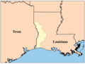
The Neutral Ground
See also
 In Spanish: Zona neutral entre el río Sabina y el arroyo Hondo para niños
