
Beauregard Parish, Louisiana facts for kids
Quick facts for kids
Beauregard Parish
|
|
|---|---|

Beauregard Parish Courthouse in DeRidder
|
|

Location within the U.S. state of Louisiana
|
|
 Louisiana's location within the U.S. |
|
| Country | |
| State | |
| Founded | January 1, 1913 |
| Named for | P. G. T. Beauregard |
| Seat | DeRidder |
| Largest city | DeRidder |
| Area | |
| • Total | 1,166 sq mi (3,020 km2) |
| • Land | 1,157 sq mi (3,000 km2) |
| • Water | 8.5 sq mi (22 km2) 0.7% |
| Population
(2020)
|
|
| • Total | 36,549 |
| • Density | 31.346/sq mi (12.103/km2) |
| Time zone | UTC−6 (Central) |
| • Summer (DST) | UTC−5 (CDT) |
| Congressional district | 4th |
Beauregard Parish (also called Paroisse de Beauregard in French) is a special type of county in Louisiana, a state in the United States. In 2020, about 36,549 people lived here. The main town and biggest city is DeRidder. Beauregard Parish was officially created on January 1, 1913.
This parish is part of the DeRidder, Louisiana, area. It is governed by a group called the police jury.
Contents
History of Beauregard Parish
Early Land Ownership: Spanish and French Rule
Before 1762, the land that is now Beauregard Parish was part of Spain's territory in Louisiana. The border between Spain and France was the Calcasieu River. However, France was starting to settle land west of this river.
In 1762, the King of France secretly gave Louisiana to Spain. This was done through a special agreement called the Treaty of Fontainebleau. So, from 1762 to 1800, the area was part of New Spain.
Then, in 1800, another secret agreement, the Third Treaty of San Ildefonso, gave Louisiana back to France. Spain still managed the land until 1803. During these years, only a few European settlers lived in the area. They had special land grants from Spain.
The Neutral Ground: A Lawless Area
In 1803, the United States bought Louisiana from France. This was called the Louisiana Purchase. After this, both Spain and the United States claimed the land between the Sabine River and the Calcasieu River.
To avoid a war, both countries agreed to make this land a neutral zone. No armed forces from either side were allowed there. This area became known as the Neutral Ground or the Sabine Free State.
During this time, the area had very little law enforcement. It was often a place for outlaws. However, some brave pioneers did settle there. The border dispute was finally settled in 1821. The Adams-Onís Treaty made the Sabine River the official western border of Louisiana.
How Beauregard Parish Was Formed
In 1804, the United States organized Louisiana as the Territory of Orleans. This territory was divided into counties. Opelousas County covered a large part of southwestern Louisiana.
By 1807, these counties were changed into parishes. St. Landry Parish was one of the first parishes. It was very large and sometimes called "Imperial St. Landry Parish."
Later, on March 24, 1840, Calcasieu Parish was created from the western part of St. Landry Parish. Calcasieu Parish was also very large, known as "Imperial Calcasieu Parish." Over time, it was divided into five smaller parishes.
The bill to create Beauregard Parish passed in 1912. It officially started on January 1, 1913. The parish was named after P.G.T. Beauregard, a general from the Confederate side during the American Civil War.
Organizing the Parish Government
The town of DeRidder was chosen as the parish seat on October 15, 1912. Some people wanted Singer to be the main town, but DeRidder won the vote. Today, Singer is still a small community with a post office and school.
Beauregard Parish set up its government with a police jury. This group helps manage the parish. Elections were held in December 1912 for important local officials. These included the sheriff, clerk of court, and school board members.
Native American History
When Beauregard Parish was founded, at least four different tribes lived in the area. One tribe lived near Sugartown, and another near Bundick Creek. Other tribes were found near Anacoco Creek and in Merryville.
The 1941 Military Build-Up
In 1941, a United Service Organizations (USO) center opened in DeRidder. This was the first USO center in the U.S. that was not on a military base. Many soldiers visited this USO during World War II. They could take showers, watch movies, and relax there. The building is now a historic place.
From August to September 1941, a huge military training exercise happened nearby. It was called the Louisiana Maneuvers. More than 500,000 soldiers trained for war. Because so many soldiers were in the area, the people of Beauregard Parish voted to become a "dry parish." This meant that selling alcohol was not allowed.
Law Enforcement
The main law enforcement agency in the parish is the Beauregard Parish Sheriff's Office. The current Sheriff (as of 2020) is Mark V. Herford.
Geography of Beauregard Parish
Beauregard Parish covers about 1,166 square miles. Most of this area, 1,157 square miles, is land. About 8.5 square miles (0.7%) is water.
Main Roads
 U.S. Highway 171
 U.S. Highway 190
 Louisiana Highway 12
 Louisiana Highway 26
 Louisiana Highway 27
Neighboring Areas
Beauregard Parish shares borders with several other parishes and one county:
- Vernon Parish (to the north)
- Allen Parish (to the east)
- Jefferson Davis Parish (to the southeast)
- Calcasieu Parish (to the south)
- Newton County, Texas (to the west)
Population Facts
| Historical population | |||
|---|---|---|---|
| Census | Pop. | %± | |
| 1920 | 20,767 | — | |
| 1930 | 14,569 | −29.8% | |
| 1940 | 14,847 | 1.9% | |
| 1950 | 17,766 | 19.7% | |
| 1960 | 19,191 | 8.0% | |
| 1970 | 22,888 | 19.3% | |
| 1980 | 29,692 | 29.7% | |
| 1990 | 30,083 | 1.3% | |
| 2000 | 32,986 | 9.6% | |
| 2010 | 35,654 | 8.1% | |
| 2020 | 36,549 | 2.5% | |
| U.S. Decennial Census 1790-1960 1900-1990 1990-2000 2010 |
|||
In 2020, the U.S. census counted 36,549 people living in Beauregard Parish. There were 13,520 households and 9,219 families.
| Race | Number | Percentage |
|---|---|---|
| White (non-Hispanic) | 29,039 | 79.45% |
| Black or African American (non-Hispanic) | 4,082 | 11.17% |
| Native American | 273 | 0.75% |
| Asian | 222 | 0.61% |
| Pacific Islander | 27 | 0.07% |
| Other/Mixed | 1,635 | 4.47% |
| Hispanic or Latino | 1,271 | 3.48% |
Education
The Beauregard Parish School Board is in charge of the public schools in the parish. The area is also served by Sowela Technical Community College.
National Guard
A local military unit, the A Company, 3-156th Infantry Battalion, is based in De Ridder. This unit has served in Iraq twice, in 2004-2005 and 2010.
Communities in Beauregard Parish

Cities
- DeRidder (This is the main town and the largest city in the parish.)
Towns
Unincorporated Areas
These are communities that are not officially part of a city or town.
Census-designated places
Other Communities
Historic Places
There are 12 places in Beauregard Parish that are listed on the National Register of Historic Places. These include the Beauregard Parish Courthouse, the Beauregard Parish Jail, and the DeRidder Commercial Historic District. You can find a full list at National Register of Historic Places listings in Beauregard Parish, Louisiana.
Images for kids
-
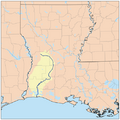
The Calcasieu River formed part of the eastern boundary of the Neutral Ground.
-
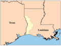
The Neutral Ground, or Sabine Free State. Its western border was the Sabine River.


See also
 In Spanish: Parroquia de Beauregard para niños
