
St. Landry Parish, Louisiana facts for kids
Quick facts for kids
St. Landry Parish
|
|
|---|---|

|
|

Location within the U.S. state of Louisiana
|
|
 Louisiana's location within the U.S. |
|
| Country | |
| State | |
| Founded | 1807 |
| Named for | St. Landry Catholic Church |
| Seat | Opelousas |
| Largest city | Opelousas |
| Area | |
| • Total | 939 sq mi (2,430 km2) |
| • Land | 924 sq mi (2,390 km2) |
| • Water | 15 sq mi (40 km2) 1.6% |
| Population
(2020)
|
|
| • Total | 82,540 |
| • Estimate
(2022)
|
82,786 |
| • Density | 87.90/sq mi (33.939/km2) |
| Time zone | UTC−6 (Central) |
| • Summer (DST) | UTC−5 (CDT) |
| Congressional districts | 3rd, 4th, 5th |
St. Landry Parish (which means Parish of Saint-Landry in French) is a special kind of county in the state of Louisiana. In 2020, about 82,540 people lived there. The main town and government center is Opelousas. This parish was created in 1807.
St. Landry Parish is a central part of Creole and Cajun culture in Louisiana. It is also part of a larger area called the Opelousas Micropolitan Statistical Area.
Contents
History of St. Landry Parish
Early French and Spanish Control
People have lived in the area that is now St. Landry Parish since at least 10,500 B.C. We know this from old dwelling sites found there. By the 1400s, the Opelousa Indians lived between the Atchafalaya River and the Sabine River. The Opelousa were known for being strong defenders of their land.
The first European to visit the Opelousa territory was a French trader named Michel de Birotte in 1690. He made agreements with the Opelousa people. Nine years later, France claimed Louisiana as a colony. They called the land where the Opelousa lived the Opelousas Territory.
In 1764, France set up the Opelousas Post a little north of today's city of Opelousas. This post was important for trade in the growing area. France also gave land to soldiers and settlers to help the area grow. Most of these early settlers were French.
Some Native American tribes sold land to the new settlers. However, when the Eastern Attakapas Chief Kinemo sold land to a Frenchman in 1760, the Opelousa tribe became angry. They fought and defeated the Attakapas.
In 1762, France gave Louisiana and its territories to Spain. Under Spanish rule, Opelousas Post became the main government center for Southwest Louisiana. By 1769, about 100 families lived in Opelousas Post. More settlers arrived between 1780 and 1820. These new people came from other parts of Louisiana and from the French West Indies. Most were French, Spanish, French Creoles, Spanish Creoles, and African-Americans.
Many Acadians also came from Nova Scotia in 1763. They were French people who had been forced to leave their homes by the English. The French community built the St. Landry Catholic Church by 1766. It was named after St. Landry (Landericus) of Paris, a bishop in Paris in the 600s.
United States Takes Control

The United States took control of this land in 1803 through the Louisiana Purchase. Americans from other parts of the U.S. began to move here. This brought the first large group of English-speaking people to the area.
St. Landry Parish was officially created on April 10, 1805. It was the largest parish in Louisiana at the time. The new parish was named after the St. Landry Catholic Church. Its original borders covered about half of the old Opelousas Territory. Over time, the parish became smaller as six new parishes were created from its land. These include Calcasieu, Acadia, Evangeline, Jeff Davis, Beauregard, and Allen.
In 1821, the Academy of the Sacred Heart was founded in Grand Coteau. This private Catholic school was one of the first schools west of the Mississippi River.
Opelousas has always been the main government town for St. Landry Parish. During the American Civil War, when Baton Rouge was taken by Union troops in 1862, Opelousas became the state capital for nine months. The capital moved again in 1863 to Shreveport.
St. Landry Parish was divided again in 1886. The southwestern part became Acadia Parish. Later, in 1910, the northwestern part became Evangeline Parish.
Opelousas Massacre
After the Civil War, there was a lot of tension in Louisiana. In 1868, a white teacher and newspaper editor named Emerson Bentley was attacked in Opelousas. He was a Republican and taught Black children. Rumors spread that he had died, which caused more trouble.
This led to a terrible event called the Opelousas Massacre. White groups, including the Knights of the White Camelia, attacked Black citizens. Many Black people were chased, captured, and killed over several weeks. Historians believe between 200 and 300 Black people died, along with some white people. This was one of the deadliest events during the Reconstruction Era. After this, the Republican Party in St. Landry Parish was not active for many years.
Geography of St. Landry Parish
St. Landry Parish covers about 939 square miles. Most of this is land, with about 15 square miles of water.
Neighboring Parishes
St. Landry Parish shares borders with these other parishes:
- Avoyelles Parish (north)
- Pointe Coupee Parish (east)
- St. Martin Parish (southeast)
- Lafayette Parish (south)
- Acadia Parish (southwest)
- Evangeline Parish (west and northwest)
Protected Natural Areas
- Atchafalaya National Wildlife Refuge (part of it is in St. Landry Parish)
- Jean Lafitte National Historical Park and Preserve (part of it is in Eunice)
Main Roads
 Interstate 49
 U.S. Highway 71
 U.S. Highway 167
 U.S. Highway 190
 Louisiana Highway 10
 Louisiana Highway 13
 Louisiana Highway 29
 Louisiana Highway 31
 Louisiana Highway 35
 Louisiana Highway 91
 Louisiana Highway 93
 Louisiana Highway 103
 Louisiana Highway 182
Population of St. Landry Parish
| Historical population | |||
|---|---|---|---|
| Census | Pop. | %± | |
| 1830 | 12,591 | — | |
| 1840 | 15,233 | 21.0% | |
| 1850 | 22,253 | 46.1% | |
| 1860 | 23,104 | 3.8% | |
| 1870 | 25,553 | 10.6% | |
| 1880 | 40,004 | 56.6% | |
| 1890 | 40,250 | 0.6% | |
| 1900 | 52,906 | 31.4% | |
| 1910 | 66,661 | 26.0% | |
| 1920 | 51,697 | −22.4% | |
| 1930 | 60,074 | 16.2% | |
| 1940 | 71,481 | 19.0% | |
| 1950 | 78,476 | 9.8% | |
| 1960 | 81,493 | 3.8% | |
| 1970 | 80,364 | −1.4% | |
| 1980 | 84,128 | 4.7% | |
| 1990 | 80,331 | −4.5% | |
| 2000 | 87,700 | 9.2% | |
| 2010 | 83,384 | −4.9% | |
| 2020 | 82,540 | −1.0% | |
| U.S. Decennial Census 1790-1960 1900-1990 1990-2000 2010 |
|||
As of the 2020 Census, there were 82,540 people living in St. Landry Parish.
Law Enforcement
| St. Landry Parish Sheriff's Office | |
|---|---|
| Abbreviation | SLPSO |
| Jurisdictional structure | |
| Operations jurisdiction | United States |
| General nature | |
| Operational structure | |
| Headquarters | Opelousas, Louisiana |
| Agency executive |
|
| Facilities | |
| Substations | 5 |
| Website | |
| http://www.slpsheriff.com/ | |
The St. Landry Parish Sheriff's Office (SLPSO) is the main law enforcement group in the parish. It is led by the Sheriff, who is the chief law enforcement officer. As of 2022, the sheriff of St. Landry Parish is Bobby J. Guidroz.
Education in St. Landry Parish
St. Landry Parish has many schools for students of all ages.
Public Schools
The St. Landry Parish School Board manages the public schools.
- Arnaudville Elementary (Grades 5–8)
- Beau Chene High School (Grades 9–12)
- Cankton Elementary (Grades PK-4)
- Central Middle School (Grades 5–6)
- East Elementary (Grades PK-4)
- Eunice Elementary (Grades PK-4)
- Eunice High School (Grades 9–12)
- Eunice Jr. High School (Grades 7–8)
- Glendale Elementary (Grades PK-4)
- Grand Coteau Elementary (Grades PK-4)
- Grand Prairie Elementary (Grades PK-4)
- Grolee Elementary (Grades PK-4)
- Highland Elementary (Grades PK-4)
- Krotz Springs Elementary (Grades PK-8)
- Lawtell Elementary (Grades PK-8)
- Leonville Elementary (Grades PK-8)
- North Central High School (Grades 9–12)
- Northeast Elementary (Grades PK-6)
- Northwest High School (Grades 9–12)
- Opelousas Jr. High School (Grades 7–8)
- Opelousas Sr. High School (Grades 9–12)
- Palmetto Elementary (Grades PK-4)
- Park Vista Elementary (Grades PK-6)
- Plaisance Elementary (Grades 5–8)
- Port Barre Elementary (Grades PK-4)
- Port Barre High School (Grades 5–12)
- South Street Elementary (Grades PK-6)
- Sunset Elementary (Grades 5–8)
- Washington Elementary (Grades PK-8)
Private Schools
The Diocese of Lafayette runs five Catholic schools:
- Academy of the Sacred Heart (Grades PK-12)
- Berchman's Academy of the Sacred Heart (Grades PK-12)
- Opelousas Catholic School (Grades PK-12)
- St. Edmunds Catholic School (Grades PK-12)
- St. Ignatius Catholic School (Grades PK-8)
There are also four other private schools:
- Good Shephard Montessori School (Grades PK-8)
- Melville Private School (Grades PK-7)
- Opelousas Family Worship School (Grades PK-12)
- Westminster Christian Academy (Grades PK-12)
Colleges and Universities
St. Landry Parish has two places for higher education:
- Louisiana State University at Eunice
- South Louisiana Community College, T. H. Harris Campus (Opelousas)
Communities in St. Landry Parish

Cities
Towns
Villages
Other Communities
These areas are not officially cities, towns, or villages:
Notable People from St. Landry Parish
Many interesting people have come from St. Landry Parish, including:
- Lottie Beebe
- Rod Bernard
- Carl A. Brasseaux
- Gerald Boudreaux
- Lonnie Brooks
- Tony Chachere
- Clifton Chenier
- Cat Doucet
- Gilbert L. Dupré
- E. D. Estilette
- Gordon (slave)
- Curtis J. Guillory
- Elbert Guillory
- Clay Higgins
- Rodney Milburn
- Paul Prudhomme
- Devery Henderson
Images for kids
-
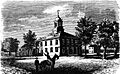
The St. Landry Parish Courthouse in Opelousas during the Civil War
-
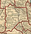
1893 Map of St. Landry Parish
-
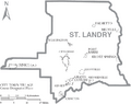
Map of St. Landry Parish, Louisiana With Municipal Labels
See also
 In Spanish: Parroquia de St. Landry para niños
