Eunice, Louisiana facts for kids
Quick facts for kids
Eunice, Louisiana
|
|
|---|---|
| City of Eunice | |
| Motto(s):
"Louisiana's Prairie Cajun Capital"
|
|

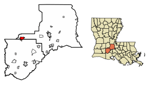
Location of Eunice in St. Landry Parish, Louisiana.
|
|
| Country | United States |
| State | Louisiana |
| Parishes | Acadia, St. Landry |
| Chartered (village) | September 12, 1894 |
| Incorporated (town) | June 4, 1895 |
| Founded by | C.C. Duson |
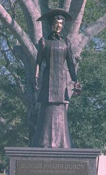
| Named for | Eunice Pharr Duson, wife of C.C. Duson |
| Area | |
| • Total | 5.14 sq mi (13.31 km2) |
| • Land | 5.14 sq mi (13.31 km2) |
| • Water | 0.00 sq mi (0.00 km2) |
| Elevation | 49 ft (15 m) |
| Population
(2020)
|
|
| • Total | 9,422 |
| • Density | 1,833.79/sq mi (708.09/km2) |
| Time zone | UTC-6 (CST) |
| • Summer (DST) | UTC-5 (CDT) |
| ZIP code |
70535
|
| Area code(s) | 337 |
| FIPS code | 22-24565 |
| Website | Eunice, Louisiana |
Eunice is a city in the state of Louisiana, USA. It is located across two parishes: Acadia and St. Landry. In 2020, about 9,422 people lived there.
The part of Eunice in St. Landry Parish is near Opelousas. The part in Acadia Parish is near Crowley.
Contents
History of Eunice
How Eunice Was Founded
A man named C.C. Duson helped start Eunice. He named the city after his second wife, Eunice Pharr Duson. C.C. Duson and his brother, W.W. Duson, had already founded another city called Crowley, Louisiana in 1887.
C.C. Duson bought a large piece of land, about 160 acres (0.65 km²), from Willie Humble. He then planned out the town, dividing it into many smaller lots. He also convinced the Southern Pacific Railroad to build a train line from Crowley to his new town.
Eunice officially became a village on September 12, 1894. It became a town on June 4, 1895.
Parish Changes and Events
In 1908, a new parish called Evangeline Parish was created. Eunice and another town, Ville Platte, both wanted to be the main city (parish seat) of this new parish. However, Ville Platte was chosen by voters in 1909. After this, Eunice decided to stay part of St. Landry Parish.
In May 2000, a freight train carrying chemicals had an accident in Eunice. Some of the chemicals spilled, and about 15 train cars caught fire and exploded. Around 3,500 people living in the town had to leave their homes for up to five days to stay safe. Later, money was paid to help the residents who were affected by the accident.
Geography and Climate
Where Eunice Is Located
Eunice covers about 4.7 square miles (12.1 km²) of land. It is located in the southwestern part of Louisiana.
Two main roads go through Eunice. Louisiana Highway 13 and U.S. Highway 190 pass through the center of the city. U.S. 190 goes west to Kinder and east to Opelousas. LA-13 goes north to Mamou and south to Crowley.
Eunice Weather
The weather in Eunice is usually hot and humid in the summer. Winters are generally mild to cool. This type of weather is called a humid subtropical climate. It means the area gets a lot of rain and has warm temperatures for most of the year.
| Climate data for Eunice, Louisiana (1991–2020 normals, extremes 1982–2015) | |||||||||||||
|---|---|---|---|---|---|---|---|---|---|---|---|---|---|
| Month | Jan | Feb | Mar | Apr | May | Jun | Jul | Aug | Sep | Oct | Nov | Dec | Year |
| Record high °F (°C) | 84 (29) |
83 (28) |
88 (31) |
94 (34) |
101 (38) |
103 (39) |
104 (40) |
107 (42) |
109 (43) |
98 (37) |
89 (32) |
84 (29) |
109 (43) |
| Mean daily maximum °F (°C) | 59.9 (15.5) |
64.2 (17.9) |
71.2 (21.8) |
77.6 (25.3) |
84.7 (29.3) |
90.2 (32.3) |
92.0 (33.3) |
93.0 (33.9) |
88.9 (31.6) |
80.7 (27.1) |
70.0 (21.1) |
62.5 (16.9) |
77.9 (25.5) |
| Daily mean °F (°C) | 49.9 (9.9) |
54.2 (12.3) |
60.9 (16.1) |
67.2 (19.6) |
75.2 (24.0) |
80.8 (27.1) |
82.6 (28.1) |
82.9 (28.3) |
78.4 (25.8) |
69.0 (20.6) |
59.2 (15.1) |
52.2 (11.2) |
67.7 (19.8) |
| Mean daily minimum °F (°C) | 39.8 (4.3) |
44.2 (6.8) |
50.6 (10.3) |
56.9 (13.8) |
65.6 (18.7) |
71.3 (21.8) |
73.2 (22.9) |
72.8 (22.7) |
67.8 (19.9) |
57.2 (14.0) |
48.4 (9.1) |
41.9 (5.5) |
57.5 (14.2) |
| Record low °F (°C) | 14 (−10) |
15 (−9) |
23 (−5) |
34 (1) |
41 (5) |
53 (12) |
62 (17) |
58 (14) |
44 (7) |
30 (−1) |
25 (−4) |
9 (−13) |
9 (−13) |
| Average precipitation inches (mm) | 6.43 (163) |
4.62 (117) |
3.91 (99) |
4.62 (117) |
5.69 (145) |
4.84 (123) |
4.61 (117) |
4.24 (108) |
4.90 (124) |
4.86 (123) |
4.43 (113) |
4.79 (122) |
57.94 (1,472) |
| Average snowfall inches (cm) | 0.0 (0.0) |
0.0 (0.0) |
0.0 (0.0) |
0.0 (0.0) |
0.0 (0.0) |
0.0 (0.0) |
0.0 (0.0) |
0.0 (0.0) |
0.0 (0.0) |
0.0 (0.0) |
0.0 (0.0) |
0.0 (0.0) |
0.0 (0.0) |
| Average precipitation days (≥ 0.01 in) | 10.1 | 8.7 | 7.9 | 6.8 | 6.8 | 10.7 | 10.6 | 8.9 | 7.0 | 6.3 | 7.5 | 9.0 | 100.3 |
| Average snowy days (≥ 0.1 in) | 0.0 | 0.0 | 0.0 | 0.0 | 0.0 | 0.0 | 0.0 | 0.0 | 0.0 | 0.0 | 0.0 | 0.0 | 0.0 |
| Source: NOAA | |||||||||||||
Eunice's Parishes
Eunice is unique because it is located in parts of three different parishes: St. Landry, Acadia, and Evangeline. This is why some businesses in Eunice have names like "Tri-Parish Bank." Most of the Evangeline Parish part of Eunice is not officially part of the city.
St. Landry Parish Section
Most of Eunice is located within St. Landry Parish. This parish is one of the oldest in Louisiana.
Acadia Parish Section
Acadia Parish is to the south of Eunice. It borders most of the southern city limits. On the west side, the city limits extend south into Acadia Parish. This area includes the airport and the Louisiana State University Eunice campus. Acadia Parish was also formed from parts of St. Landry Parish.
Population and People
| Historical population | |||
|---|---|---|---|
| Census | Pop. | %± | |
| 1900 | 316 | — | |
| 1910 | 1,684 | 432.9% | |
| 1920 | 3,272 | 94.3% | |
| 1930 | 3,597 | 9.9% | |
| 1940 | 5,242 | 45.7% | |
| 1950 | 8,184 | 56.1% | |
| 1960 | 11,326 | 38.4% | |
| 1970 | 11,390 | 0.6% | |
| 1980 | 12,479 | 9.6% | |
| 1990 | 11,162 | −10.6% | |
| 2000 | 11,499 | 3.0% | |
| 2010 | 10,398 | −9.6% | |
| 2020 | 9,422 | −9.4% | |
| U.S. Decennial Census | |||
| Race | Number | Percentage |
|---|---|---|
| White (non-Hispanic) | 5,448 | 57.82% |
| Black or African American (non-Hispanic) | 3,289 | 34.91% |
| Native American | 12 | 0.13% |
| Asian | 89 | 0.94% |
| Other/Mixed | 312 | 3.31% |
| Hispanic or Latino | 272 | 2.89% |
In 2020, Eunice had 9,422 people living there. There were 3,642 households and 2,470 families. In 2010, the city had 10,398 people.
The people living in Eunice come from different backgrounds. In 2010, about 63.0% were White, 32.5% were Black, and smaller groups were Native American, Asian, or from two or more races. About 2.3% of the population was Hispanic or Latino.
In 2000, there were 11,499 people and 4,316 households. About 34.8% of households had children under 18. The average household had about 2.59 people. The average family had about 3.18 people.
The population was spread out by age. About 29.6% were under 18, and 15.5% were 65 or older. The average age in Eunice was 35 years old.
Arts and Culture in Eunice
Cajun Music and Culture
Eunice is in the heart of Cajun country. It is well-known for its lively Cajun music. The Cajun Music Hall of Fame and Museum was started here in November 1997.
Every Saturday night, the City of Eunice and the National Park Service host a live Cajun music show. It's called "Laissez les bons temps rouler au rendezvous des cajuns" (which means "Let the good times roll at the Cajun gathering"). This show takes place at the Liberty Theatre, an old movie theater that local volunteers helped restore.
Eunice is also home to the Prairie Acadian Cultural Center. This center is part of the Jean Lafitte National Historical Park and Preserve. It helps people learn about Cajun culture.
Festivals and Events
Eunice hosts one of the biggest Courir de Mardi Gras. This is a traditional rural French Louisiana way of celebrating Mardi Gras. The city also holds the World Championship Crawfish Étouffée Cook-off, where people compete to make the best crawfish étouffée.
Since 2015, the Eunice Rotary Club and the Jean Lafitte National Park and Preserve have hosted the Experience Louisiana Festival. This festival celebrates local traditions and culture every October at the LSU Eunice campus.
Education
Eunice has several schools and a university campus.
Louisiana State University Eunice is located here. It is a community college and part of the larger Louisiana State University system.
The city also has two high schools: Eunice High School and St Edmund High School.
Notable People
Many interesting people have connections to Eunice, including:
- Danneel Ackles (nee Harris), an actress.
- Geno Delafose, a Zydeco musician.
- Mary Alice Fontenot, who wrote the "Clovis the Crawfish" book series.
- Joe Hall, an accordion player known for Creole la la, Cajun, and zydeco styles.
- Kyries Hebert, a free safety who played American football in the NFL.
- Deante Adam Johnson (Summrs), a music artist.
- C.W. Lemoine, an author and Air Force aviator.
- Carlton Loewer, a Major League Baseball pitcher.
- Dennis McGee, a Cajun musician.
- Keith Ortego, an American football wide receiver who played for the Super Bowl XX champion Chicago Bears.
- Ann Savoy, a Cajun accordionist.
- Marc Savoy, a Cajun accordionist and accordion maker.
- Tharold Simon, an NFL cornerback.
- Cora Kelley Ward, a painter.
- Jay Young, a television news anchor.
See also
 In Spanish: Eunice (Luisiana) para niños
 | Bessie Coleman |
 | Spann Watson |
 | Jill E. Brown |
 | Sherman W. White |


