Krotz Springs, Louisiana facts for kids
Quick facts for kids
Krotz Springs, Louisiana
|
|
|---|---|
|
Town
|
|
| Town of Krotz Springs | |

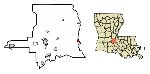
Location of Krotz Springs in St. Landry Parish, Louisiana.
|
|

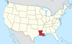
Location of Louisiana in the United States
|
|
| Country | United States |
| State | Louisiana |
| Parish | St. Landry |
| Area | |
| • Total | 1.73 sq mi (4.49 km2) |
| • Land | 1.73 sq mi (4.47 km2) |
| • Water | 0.01 sq mi (0.01 km2) |
| Elevation | 30 ft (9 m) |
| Population
(2020)
|
|
| • Total | 904 |
| • Density | 523.15/sq mi (202.02/km2) |
| Time zone | UTC-6 (CST) |
| • Summer (DST) | UTC-5 (CDT) |
| ZIP |
70750
|
| Area code(s) | 337 |
| FIPS code | 22-40280 |
Krotz Springs is a small town located in St. Landry Parish, Louisiana, in the United States. It sits right on the Atchafalaya River. In 2020, about 904 people lived there. The town is part of a larger area that includes the cities of Opelousas and Eunice.
Contents
History of Krotz Springs
How the Town Began
Around the early 1900s, a man named Charles William Krotz from Ohio bought a huge piece of land, about 20,000 acres, near the Atchafalaya Basin. He started a sawmill there to cut down trees from the basin. A small community grew around this mill.
This settlement was first called Latania. This name came from a nearby bayou and the type of palm plants, called fan palms, found in the area.
The Famous Spring
Charles Krotz thought there might be oil underground. In 1900, he tried to drill for oil, hoping to find a big oil field in St. Landry Parish. But instead of oil, he found water! This water source became known as Krotz’s spring.
The spring provided water for the growing sawmill town. Krotz even bottled this water and sold it across the country. In 1909, a post office was opened in the town. It was an easy choice to name the town Krotz Springs after the spring and its founder.
Bridges Over the Atchafalaya River
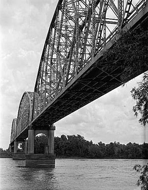
The first Krotz Springs Bridge was built across the Atchafalaya River in 1928. This bridge was used by both trains and cars. Over the years, new bridges were built in the same spot to replace the old ones. These new bridges opened in 1934, 1973, and 1988.
Leaders of Krotz Springs: The Mayors
The mayor is the main leader of a town. They help make decisions and manage the town's services. Robert A. Moran, a member of the Democratic Party, was mayor from 1986 until he passed away in 1987.
After him, James Rasie Nall became mayor in 1987. Then, in 1990, Gary Soileau won the election by a lot of votes. He was mayor until he retired in 2010. The current mayor, Carroll Snyder, also a Democrat, took over after Gary Soileau.
List of Mayors Since 1917
Here is a list of most of the mayors who have led Krotz Springs since 1917:
| Charles W. Krotz | 1917 - 1925 |
| Lester Lemoine | 1926 - ? |
| James Edward Helton | 1930 - 1932 |
| Ralph DelBuono | 1932 - ? |
| Eddie Eusay | 1944 - 1950 |
| Clinton C Artigue | 1950 - 1954 |
| Eddie Eusay | 1955 - 1956 |
| Robert Humphreys | 1956 - 1958 |
| James Rasie Nall | 1958 - 1986 |
| Robert A Moran | 1986 - 1987 |
| James Rasie Nall | 1987 - 1989 |
| Gary Soileau | 1989 - 2010 |
| Carroll Snyder | 2010 – Present |
Geography and Location
Krotz Springs is located at 30°32′15″N 91°45′18″W / 30.53750°N 91.75500°W. It is on the eastern edge of St. Landry Parish. Across the Atchafalaya River to the east is Pointe Coupee Parish. You can cross the river using U.S. Highway 190.
The city of Opelousas, which is the main town of St. Landry Parish, is about 20 miles (32 km) west of Krotz Springs. The larger city of Baton Rouge is about 40 miles (64 km) to the east. The United States Census Bureau says the town covers about 1.7 square miles (4.4 square kilometers) of land.
Population and Demographics
Demographics means the facts about a population, like how many people live somewhere and what groups they belong to.
| Historical population | |||
|---|---|---|---|
| Census | Pop. | %± | |
| 1920 | 247 | — | |
| 1930 | 449 | 81.8% | |
| 1940 | 630 | 40.3% | |
| 1950 | 866 | 37.5% | |
| 1960 | 1,057 | 22.1% | |
| 1970 | 1,435 | 35.8% | |
| 1980 | 1,374 | −4.3% | |
| 1990 | 1,285 | −6.5% | |
| 2000 | 1,219 | −5.1% | |
| 2010 | 1,198 | −1.7% | |
| 2020 | 904 | −24.5% | |
| U.S. Decennial Census | |||
2020 Census Information
According to the 2020 United States census, there were 904 people living in Krotz Springs. There were 373 households and 242 families.
Here is a breakdown of the different groups of people living in Krotz Springs in 2020:
| Race | Number | Percentage |
|---|---|---|
| White people (not Hispanic) | 827 | 91.48% |
| Black or African American people (not Hispanic) | 7 | 0.77% |
| Native American people | 5 | 0.55% |
| Asian people | 1 | 0.11% |
| Other or Mixed races | 37 | 4.09% |
| Hispanic or Latino people | 27 | 2.99% |
2010 Census Information
In the 2010 United States Census, Krotz Springs had 1,198 people. Most of the people were White (97.2%). A small number were Black (0.2%), Native American (0.3%), Asian (0.4%), or from two or more races (0.3%). About 1.5% of the population was Hispanic or Latino.
Movies Filmed Near Krotz Springs
Krotz Springs and its surroundings have been used as filming locations for several movies:
- 1966: Some prison camp scenes for the movie Nevada Smith, starring Steve McQueen, were filmed just west of Krotz Springs. This was in an area called the 2 O'Clock Bayou.
- 1969: The very last scene of the movie Easy Rider, which starred Peter Fonda and Dennis Hopper, was filmed a few miles north of Krotz Springs. In this scene, the main characters are shot by two local residents on Louisiana Highway 105.
- 1998: In the movie Out of Sight, with George Clooney and Jennifer Lopez, two characters lose control of their car. This scene happens as they are driving down the Atchafalaya River Bridge on U.S. Route 190 heading west.
See also
 In Spanish: Krotz Springs para niños
 | John T. Biggers |
 | Thomas Blackshear |
 | Mark Bradford |
 | Beverly Buchanan |


