San Augustine County, Texas facts for kids
Quick facts for kids
San Augustine County
|
|
|---|---|

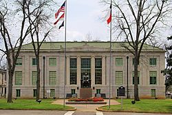
The San Augustine County Courthouse
|
|

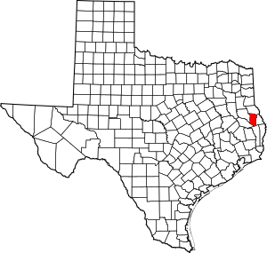
Location within the U.S. state of Texas
|
|
 Texas's location within the U.S. |
|
| Country | |
| State | |
| Founded | 1837 |
| Named for | Presidio de San Agustín de Ahumada, named for Agustín de Ahumada, 2nd Marquess of Amarillas |
| Seat | San Augustine |
| Largest city | San Augustine |
| Area | |
| • Total | 592 sq mi (1,530 km2) |
| • Land | 531 sq mi (1,380 km2) |
| • Water | 62 sq mi (160 km2) 10%% |
| Population
(2020)
|
|
| • Total | 7,918 |
| • Density | 13.375/sq mi (5.164/km2) |
| Time zone | UTC−6 (Central) |
| • Summer (DST) | UTC−5 (CDT) |
| Congressional district | 1st |
San Augustine County is a place in Texas, a state in the United States. In 2020, about 7,918 people lived there. The main town, or county seat, is called San Augustine.
Contents
History of San Augustine County
San Augustine County was created in 1837. It might have been named after a Saint called Augustine of Hippo. But it's more likely that the county got its name from the town of San Augustine. This town was started five years earlier. Its name came from an old Spanish fort, or presidio, from the 1700s. This fort was named after a person called Agustín de Ahumada, 2nd Marquess of Amarillas.
Geography and Nature
San Augustine County covers about 592 square miles. Most of this area is land, about 531 square miles. The rest, about 62 square miles, is water. This means about 10% of the county is water.
Main Roads in the County
These are the important roads that go through San Augustine County:
Neighboring Counties
San Augustine County shares borders with these other counties:
- Shelby County to the north
- Sabine County to the east
- Jasper County to the south
- Angelina County to the southwest
- Nacogdoches County to the west
Protected Natural Areas
Parts of these special natural areas are found in San Augustine County:
- Angelina National Forest
- Sabine National Forest
- Mission Dolores State Historic Site
People and Population
The number of people living in San Augustine County has changed over time. In 1850, there were 3,648 people. The population grew to 13,737 in 1920. After that, it slowly went down. In 2020, the population was 7,918.
| Historical population | |||
|---|---|---|---|
| Census | Pop. | %± | |
| 1850 | 3,648 | — | |
| 1860 | 4,094 | 12.2% | |
| 1870 | 4,196 | 2.5% | |
| 1880 | 5,084 | 21.2% | |
| 1890 | 6,688 | 31.5% | |
| 1900 | 8,434 | 26.1% | |
| 1910 | 11,264 | 33.6% | |
| 1920 | 13,737 | 22.0% | |
| 1930 | 12,471 | −9.2% | |
| 1940 | 12,471 | 0.0% | |
| 1950 | 8,837 | −29.1% | |
| 1960 | 7,722 | −12.6% | |
| 1970 | 7,858 | 1.8% | |
| 1980 | 8,785 | 11.8% | |
| 1990 | 7,999 | −8.9% | |
| 2000 | 8,946 | 11.8% | |
| 2010 | 8,865 | −0.9% | |
| 2020 | 7,918 | −10.7% | |
| U.S. Decennial Census 1850–2010 2010–2020 |
|||
In 2000, there were 8,946 people living in the county. About 69% of the people were White, and about 28% were Black or African American. A small number of people were Native American or Asian. About 3.5% of the people were Hispanic or Latino.
The population was spread out by age. About 23.7% of people were under 18 years old. About 21.4% were 65 years or older. The average age in the county was 42 years.
Towns and Communities
These are the main communities in San Augustine County:
- Black Ankle
- Benina
- Broaddus
- San Augustine (This is the county seat, the main town.)
Education in San Augustine County
Children in San Augustine County go to schools in different school districts:
- Broaddus Independent School District
- Brookeland Independent School District
- Chireno Independent School District
- San Augustine Independent School District
For higher education, the county is served by Angelina College.
Images for kids
See also
 In Spanish: Condado de San Augustine para niños
 | Lonnie Johnson |
 | Granville Woods |
 | Lewis Howard Latimer |
 | James West |


