
49th parallel north facts for kids
The 49th parallel north is an imaginary line that goes all the way around Earth. It's located 49 degrees north of the equator, which is the middle line of our planet. This line crosses through many places, including Europe, Asia, the Pacific Ocean, North America, and the Atlantic Ocean.
Did you know that the famous city of Paris in France is only about 15 kilometers (9 miles) south of this line? Paris is the biggest city located between the 48th and 49th parallels. Even Charles de Gaulle Airport, a major airport in Paris, sits right on the 49th parallel!
A large part of the Canada–United States border follows the 49th parallel. This section stretches for about 2,030 kilometers (1,260 miles) from British Columbia in Canada to Manitoba, and from Washington in the United States to Minnesota. This important international border was agreed upon in treaties like the Anglo-American Convention of 1818 and the Oregon Treaty of 1846. However, because of how they measured it back in the 1800s, the actual border can be a few meters off from the exact 49th parallel.
At this latitude, the sun stays above the horizon for a long time in summer – about 16 hours and 12 minutes during the longest day of the year (the summer solstice). In winter, during the shortest day (the winter solstice), the sun is up for only about 8 hours and 14 minutes. Also, about one-eighth of the Earth's surface is located north of the 49th parallel.
Contents
Where the 49th Parallel Crosses

Let's take a trip around the world, starting from the Prime Meridian (the zero line of longitude) and heading east. The 49th parallel north passes through many countries and bodies of water:
| Location | Country, Territory, or Sea | Notes |
|---|---|---|
| 49°0′N 0°0′E / 49.000°N 0.000°E | Crosses through Normandy, Île-de-France (including a runway at Charles de Gaulle Airport), Hauts-de-France, and Grand Est. | |
| 49°0′N 8°4′E / 49.000°N 8.067°E | Passes through Rhineland-Palatinate, Baden-Württemberg (including the city of Karlsruhe), and Bavaria (including Regensburg). | |
| 49°0′N 13°24′E / 49.000°N 13.400°E | Passes just north of the city of České Budějovice. | |
| 49°0′N 15°0′E / 49.000°N 15.000°E | Crosses a small part of Austria, about 4.8 kilometers (3 miles) long. | |
| 49°0′N 15°4′E / 49.000°N 15.067°E | Crosses back into the Czech Republic for about 5 kilometers (3 miles). | |
| 49°0′N 15°8′E / 49.000°N 15.133°E | Crosses Austria again for a very short distance (about 120 meters). | |
| 49°0′N 15°8′E / 49.000°N 15.133°E | Enters the Czech Republic once more. | |
| 49°0′N 17°57′E / 49.000°N 17.950°E | Crosses the Trenčín Region, Žilina Region, and Prešov Region, passing through the center of Prešov city. | |
| 49°0′N 22°32′E / 49.000°N 22.533°E | Passes through many regions including Zakarpattia Oblast, Lviv Oblast, Ivano-Frankivsk Oblast (through Bolekhiv and Kolomyia), Ternopil Oblast (south of Chortkiv), Khmelnytskyi Oblast, Vinnytsia Oblast (south of Zhmerynka), Cherkasy Oblast (through Shpola), Kirovohrad Oblast, Poltava Oblast (through Kremenchuk and Horishni Plavni), Dnipropetrovsk Oblast, Kharkiv Oblast, Donetsk Oblast (through Lyman), and Luhansk Oblast (through Rubizhne). | |
| 49°0′N 39°42′E / 49.000°N 39.700°E | Crosses Rostov Oblast and Volgograd Oblast. | |
| 49°0′N 46°55′E / 49.000°N 46.917°E | Passes through Kazakhstan. | |
| 49°0′N 86°44′E / 49.000°N 86.733°E | Crosses Xinjiang province. | |
| 49°0′N 87°55′E / 49.000°N 87.917°E | Passes through Mongolia. | |
| 49°0′N 116°8′E / 49.000°N 116.133°E | Crosses Inner Mongolia and Heilongjiang provinces. | |
| 49°0′N 130°0′E / 49.000°N 130.000°E | Passes through Amur Oblast, Jewish Autonomous Oblast, and Khabarovsk Krai. | |
| 49°0′N 140°21′E / 49.000°N 140.350°E | Strait of Tartary | A narrow body of water. |
| 49°0′N 142°1′E / 49.000°N 142.017°E | Crosses the island of Sakhalin. | |
| 49°0′N 142°57′E / 49.000°N 142.950°E | Sea of Okhotsk | Includes the Gulf of Patience. |
| 49°0′N 144°26′E / 49.000°N 144.433°E | Crosses the island of Sakhalin again. | |
| 49°0′N 144°27′E / 49.000°N 144.450°E | Sea of Okhotsk | Passes between the islands of Kharimkotan and Ekarma in Russia's Kuril Islands. |
| 49°0′N 154°22′E / 49.000°N 154.367°E | Pacific Ocean | The largest ocean in the world. |
| 49°0′N 125°41′W / 49.000°N 125.683°W | Crosses British Columbia, including Vancouver Island, Thetis Island, and Galiano Island, passing through Ladysmith. | |
| 49°0′N 123°34′W / 49.000°N 123.567°W | Strait of Georgia | A strait between Vancouver Island and the mainland. |
| 49°0′N 123°5′W / 49.000°N 123.083°W | Crosses Washington (specifically Point Roberts). | |
| 49°0′N 123°2′W / 49.000°N 123.033°W | Boundary Bay | Includes Semiahmoo Bay. |
| 49°0′N 122°45′W / 49.000°N 122.750°W | Crosses Washington. | |
| 49°0′N 121°56′W / 49.000°N 121.933°W | Crosses British Columbia. | |
| 49°0′N 121°25′W / 49.000°N 121.417°W | Crosses Washington. | |
| 49°0′N 120°11′W / 49.000°N 120.183°W | Crosses British Columbia. | |
| 49°0′N 119°49′W / 49.000°N 119.817°W | Crosses Washington. | |
| 49°0′N 117°18′W / 49.000°N 117.300°W | Crosses British Columbia. | |
| 49°0′N 116°28′W / 49.000°N 116.467°W | Crosses Idaho and Montana. | |
| 49°0′N 115°21′W / 49.000°N 115.350°W | Crosses British Columbia. | |
| 49°0′N 114°57′W / 49.000°N 114.950°W | Crosses Montana. | |
| 49°0′N 114°12′W / 49.000°N 114.200°W | Crosses British Columbia, Alberta, and Saskatchewan. | |
| 49°0′N 109°41′W / 49.000°N 109.683°W | Crosses Montana. | |
| 49°0′N 109°12′W / 49.000°N 109.200°W | Crosses Saskatchewan. | |
| 49°0′N 107°22′W / 49.000°N 107.367°W | Crosses Montana. | |
| 49°0′N 106°55′W / 49.000°N 106.917°W | Crosses Saskatchewan and Manitoba. | |
| 49°0′N 98°58′W / 49.000°N 98.967°W | Crosses North Dakota and Minnesota. | |
| 49°0′N 96°13′W / 49.000°N 96.217°W | Crosses Manitoba. | |
| 49°0′N 95°17′W / 49.000°N 95.283°W | Lake of the Woods | Passes just south of Big Island and Bigsby Island in Ontario, Canada. |
| 49°0′N 94°25′W / 49.000°N 94.417°W | Crosses Ontario (just north of Nipigon) and Quebec (through Girardville). | |
| 49°0′N 68°38′W / 49.000°N 68.633°W | St. Lawrence River | A large river in North America. |
| 49°0′N 66°58′W / 49.000°N 66.967°W | Crosses Quebec's Gaspé Peninsula, passing through Les Méchins and Gaspé. | |
| 49°0′N 64°24′W / 49.000°N 64.400°W | Gulf of St. Lawrence | Passes just south of Anticosti Island in Quebec, Canada. |
| 49°0′N 58°31′W / 49.000°N 58.517°W | Crosses Newfoundland and Labrador (the island of Newfoundland), passing through Bishop's Falls. | |
| 49°0′N 53°44′W / 49.000°N 53.733°W | Atlantic Ocean | The second largest ocean. |
| 49°0′N 5°38′W / 49.000°N 5.633°W | English Channel | Part of the Gulf of Saint-Malo, passing just south of the island of |
| 49°0′N 1°33′W / 49.000°N 1.550°W | Crosses Normandy. |
Important Monuments on the Parallel

Several special monuments mark the 49th parallel around the world:
- In North America, the very first monument on the western side is the Point Roberts Boundary Monument. It's located near the corner of Marine Drive and Roosevelt Way in Point Roberts, Washington, which is an exclave (a piece of land separated from its main country) south of Delta, British Columbia.
- The Peace Arch is a large, famous monument found between Surrey, British Columbia, and Blaine, Washington. It's the main feature of Peace Arch Park.
- The Waterton-Glacier International Peace Park is a special park that crosses the border between Alberta (Canada) and Montana (USA).
- The International Peace Garden is located right on the border between Manitoba (Canada) and North Dakota (USA). A new tower is planned to be built there.
- In Karlsruhe, Germany, the city marks the 49th parallel with a special stone and a painted line in the Stadtgarten (city garden).
- There's also a monument in the northern part of Prešov, Slovakia, marking the 49th parallel.
The Canada–United States Border

How the Border Was Created
Back in 1714, the Hudson's Bay Company first suggested that the 49th parallel could be the border between their lands and French territory. Later, after the United States bought the Louisiana Purchase in 1803, people generally agreed that the border with British North America should follow the natural watershed (the line where water flows in different directions).
However, it's hard to find an exact watershed line on flat plains. So, after the War of 1812, British and American committees decided on a simpler border: the 49th parallel. This was part of the Treaty of 1818. Both sides gained and lost some land, but the U.S. gained more, especially the Red River Valley. This treaty set the border from the Lake of the Woods in the east to the Rocky Mountains in the west. West of the Rockies, both countries agreed to share the Oregon Country.
Even after the border was set, local First Nations people, like the Métis, Assiniboine, Lakota, and Blackfoot, still controlled their lands. They called the 49th parallel the Medicine Line because it seemed to magically stop U.S. soldiers from crossing it.
In 1844, during a U.S. presidential election, some people wanted the border of the Oregon Territory to be even further north, at 54°40'. This led to the slogan "Fifty-Four Forty or Fight!" But in 1846, the Oregon Treaty peacefully extended the 49th parallel border all the way to the west coast, ending in the Strait of Georgia. This also created the unique situation of Point Roberts, Washington, which is a part of the U.S. that can only be reached by land through Canada.
The Border Today


Sometimes, people use "49th parallel" to mean the entire Canada-U.S. border, even though it's not exactly true. Many of Canada's most populated areas, and about 72% of its people, live south of the 49th parallel. This includes big cities like Toronto (at 43°42′ north) and Montreal (at 45°30′ north). The capital city, Ottawa, and the capitals of seven Canadian provinces are also south of this line. While three provinces (New Brunswick, Prince Edward Island, and Nova Scotia) are entirely south of the parallel, most of Canada's land is north of it.
When the 49th parallel was first surveyed in the 1800s, the tools weren't as precise as today's. So, in some places, the actual surveyed border is a few hundred feet away from where the exact 49th parallel is according to modern GPS measurements. For example, the Digital Chart of the World shows the border is, on average, about 270 meters (886 feet) south of the modern 49th parallel.
The Northwest Angle is the only part of the main 48 U.S. states that goes north of the 49th parallel. This happened because the Treaty of Paris said the border should pass through the most northwesterly point of Lake of the Woods, and this was kept even after the 1818 treaty set the 49th parallel as the border further west.
In 1909, the United States, the United Kingdom, and Canada signed a treaty that officially confirmed the original survey lines as the permanent international border. In 2002, there was a court case in Washington state that tried to argue that the state's boundary should be the exact geographical 49th parallel, not the old surveyed line. However, the court decided that the internationally agreed-upon border was the official one, no matter its exact position.
British National Grid Origin
The British national grid reference system, which is used for mapping in Great Britain, uses the point where the 49th parallel north crosses the 2° West line as its starting point. 49°00′00″N 2°00′00″W / 49.0000°N 2.0000°W
Images for kids
-
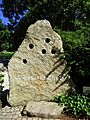
The 49th parallel north marked in Karlsruhe, Germany.
-
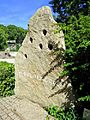
Another view of the 49th parallel north marker in Karlsruhe.
-
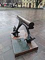
A monument marking the 49th parallel in Prešov, Slovakia.
.JPG)
.JPG)

