Red River Valley facts for kids
The Red River Valley is a special area in central North America. It gets its name because the Red River of the North flows through it. This valley stretches across parts of both Canada and the United States. It forms the border between Minnesota and North Dakota. This rich land has always been very important for the economies of these states and Manitoba, Canada.
Big cities like Moorhead, Minnesota, Fargo, Grand Forks, North Dakota, and Winnipeg, Manitoba grew up in the valley. This happened as more European settlers arrived in the late 1800s. New railroads, cheap land, and the movement of Native peoples helped attract many new settlers. Some settlers started huge farms called bonanza farms. They mainly grew wheat to sell.
Long ago, a giant ancient lake called Lake Agassiz covered this area. When the lake dried up, it left behind the Red River Valley Silts. This made the soil very fertile. For a very long time, different Native cultures lived here. This included the Ojibwe and Métis peoples. The Red River flows north through this wide, flat land that used to be the lake bottom. Because of the flat land and weather, the valley can have really big floods. Several huge floods have happened since the mid-1900s.
Contents
Early Settlers and Fur Trade
French fur traders were some of the first Europeans here. They often traded with and lived among the First Nations and Native American tribes. Many French traders married or had families with Native women. By the mid-1600s, the Métis people began to settle in the Red River Valley. They were descendants of these French traders and Cree tribes, along with other First Nations.
The Métis developed their own unique culture and way of life. Many continued to be hunters and traders in the fur trade. They also became farmers in the valley.
After winning the Seven Years' War, the British took control of French lands east of the Mississippi River. In the early 1800s, the fur trade was still very valuable. Lord Selkirk started the Red River Colony here. In 1803, the United States bought a lot of land west of the Mississippi River from France. This was called the Louisiana Purchase, and it included some of the Red River Valley.
How the U.S. Border Changed
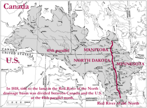
The U.S. government uses the name Red River Valley for parts of northwestern Minnesota and northeastern North Dakota. The U.S. gained control of this land after the Anglo-American Convention of 1818. This treaty set the northern border between the U.S. and Canada.
The treaty said the 49th parallel would be the official border. This line stretches from the Red River Valley all the way to the Rocky Mountains. (Later, in 1846, this border was extended to the Pacific Ocean with the Oregon Treaty.) The land the U.S. gained in the Red River Valley was huge. It was about 29 million acres! This land had been controlled by Great Britain before the treaty.
Interestingly, some land from the Louisiana Purchase was north of this new 49th parallel border. The U.S. gave this land to Britain. In return, Britain gave the Red River Valley to the U.S. This trade means that some of the northernmost parts of the Louisiana Purchase were given away by the United States. This is one of the few times the U.S. has given land to another country in North America.
Why the Red River Floods So Much
The Red River Valley is very flat, which makes it prone to flooding. Here are four main reasons why big floods happen:
Spring Thaw Timing
The Red River flows north. When spring comes, the ice and snow melt from south to north. This means that water from the southern part of the valley melts first. This meltwater then flows north and meets the melting ice and snow further north. If all this water comes together at the same time, it can cause huge floods in the northern parts of the valley.
Ice Jams
Because the river flows north, ice can build up. Ice from the southern valley moves north. It meets ice that is just breaking up in the central and northern parts of the valley. When all this ice piles up, it can block the river. This blockage, called an ice jam, stops the water from flowing. This causes the water to back up and flood the land.
Flat Lake Plain
The Red River Valley used to be the bottom of a huge ancient lake called Glacial Lake Agassiz. This area is one of the flattest places on Earth. The Red River has only cut a shallow, winding path through it. When the river overflows its banks, the water spreads out very far. This can turn the flat plain into a massive, shallow lake. The river hasn't had enough time (about 9,300 years) to carve a deep valley. So, the entire flat lake plain becomes the floodplain during floods.
Gentle Slope Downstream
The Red River has a very gentle slope, or gradient. On average, it drops only about 5 inches for every mile it flows. In some areas, like near Drayton and Pembina, the slope is even flatter, only about 1.5 inches per mile. This means the water moves very slowly in these areas. During flood season, the water tends to collect and pool in these flat spots. This can make the region look like a huge, shallow lake.
 | Bayard Rustin |
 | Jeannette Carter |
 | Jeremiah A. Brown |


