
Waterton Lake facts for kids
Quick facts for kids Waterton Lake |
|
|---|---|

Seen from Goat Haunt
|
|

Waterton Lake
Location in Montana

Waterton Lake
Location in the United States
|
|
| Location | Waterton Lakes National Park, Alberta, Canada / Glacier National Park, Glacier County, Montana, United States |
| Coordinates | 48°58′44″N 113°53′44″W / 48.9789230°N 113.8956600°W |
| Primary outflows | Waterton River |
| Basin countries | United States, Canada |
| Surface area | 10.1 km2 (3.9 sq mi) +1.5 km2 (0.58 sq mi) |
| Average depth | 80 m (260 ft) |
| Max. depth | 150 m (490 ft) |
| Surface elevation | 1,280 m (4,200 ft) |
Waterton Lake is a beautiful mountain lake located in both southern Alberta, Canada, and northern Montana, United States. It's a special place where two countries meet!
The lake is actually made of two main parts, connected by a narrow, shallow channel called the Bosporus. These parts are known as Middle Waterton Lake and Upper Waterton Lake. The Upper Lake is unique because it sits right on the Canada–United States border. About two-thirds of this lake is in Canada, and the rest is in the U.S. North of Middle Waterton Lake is Lower Waterton Lake, which is separated by another channel called the Dardanelles.
Contents
National Parks and Protected Areas
The northern part of Waterton Lake is found within Waterton Lakes National Park in Canada. The southern part, in the U.S., is located in Glacier National Park. These parks protect the amazing natural beauty and wildlife around the lake.
Waterton-Glacier International Peace Park
In 1932, Canada and the U.S. created the Waterton-Glacier International Peace Park. This park shows how two countries can work together to protect nature. It was later named an International Biosphere Reserve in 1976. This means it's a special area recognized for its unique plants and animals. In 1995, UNESCO also named it a World Heritage Site, which is a place of great importance to everyone in the world.
Waterton Biosphere Reserve
In 1979, UNESCO also set up the Waterton Biosphere Reserve around the lake. This reserve helps protect many different types of natural areas. These include wide-open grasslands, aspen parklands (forests with aspen trees), subalpine forests, and high alpine tundra areas. It also protects freshwater fens, which are a type of wetland.
Lake Size and Depth
The combined area of the upper and middle Waterton Lake system is about 10.1 km2 (3.9 sq mi). The lower lake, which is only in Canada, covers about 1.5 km2 (0.58 sq mi). The lower lake sits at an elevation of about 1,274 m (4,180 ft) above sea level.
Waterton Lake is quite deep! Early measurements in 1910 showed depths of 210 feet (64 m) and 317 feet (97 m). More recent measurements have found the lake to be as deep as 150 m (490 ft).
Highway 5 in Canada reaches its westernmost point right on the shores of Waterton Lake.
Waterton River
The Waterton River is an important river that flows out of Waterton Lake. It is part of a larger system called the South Saskatchewan River Basin.
River Flow and Path
The Waterton River flows north from Lower Waterton Lake for about 32 kilometres (20 mi) (20 miles (32 km)). It then reaches the Waterton Reservoir, which was built in 1964 near the village of Hill Spring.
From the reservoir, the river continues north for about 39 kilometres (24 mi) (24 miles (39 km)). It eventually joins with the Belly River, which is another river that flows into the Oldman River.
River Features
The Waterton River has less sediment (like dirt and sand) in its water. This is because the lakes and the reservoir act like big filters, trapping the sediment.
The total length of the Waterton River is about 80 km (50 mi). When the river is at its fullest, its average flow is about 80 cubic meters per second.
River Tributaries
Several smaller streams and creeks flow into the Waterton River. These are called tributaries. Some of them include:
- Foothill Creek
- Drywood Creek
- Yarrow Creek
- Dungarvan Creek
- Galwey Brook
- Cottonwood Creek
- Crooked Creek
Images for kids
-
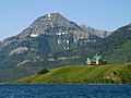
Upper Waterton Lake with the Prince of Wales Hotel and Mount Richards
-
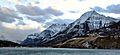
Waterton Lake in winter
-
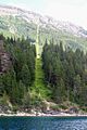
The 49th parallel north (the Canada-U.S. border) at Waterton Lake
-
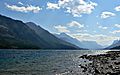
Looking south across Waterton Lake.


