
Waterton Lakes National Park facts for kids
Quick facts for kids Waterton Lakes National Park |
|
|---|---|
|
IUCN Category II (National Park)
|
|

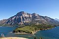
Upper Waterton Lake
|
|

Waterton Lakes National Park
Location in Canada

Waterton Lakes National Park
Location in Alberta
|
|
| Location | Alberta, Canada |
| Nearest city | Pincher Creek |
| Area | 505 km2 (195 sq mi) |
| Established | 1895 (national park) 1979 (biosphere reserve) 1995 (world heritage site) |
| Visitors | 402,542 (in 2012/13) |
| Governing body | I.D. Council, Parks Canada |
| World Heritage site | 354 |
Waterton Lakes National Park is a beautiful place in the southwest corner of Alberta, Canada. It shares a border with Glacier National Park in Montana, United States. Waterton was Canada's fourth national park, created in 1895. It was named after Waterton Lake, which in turn was named after a naturalist and conservationist named Charles Waterton. The park sits where the Rocky Mountains meet the prairies. It covers 505 km2 (195 sq mi) of wild mountains and natural landscapes.
Parks Canada manages Waterton Lakes National Park, and it's open all year. However, most visitors come in July and August. The only shops and places to stay inside the park are in the Waterton Park townsite. The park's elevation goes from 1,290 metres (4,232 ft) at the townsite up to 2,910 m (9,547 ft) at Mount Blakiston. It has many amazing trails, like the famous Crypt Lake trail. In 2012 and 2013, over 400,000 people visited Waterton Lakes National Park.
Contents
History of the Park
The idea for a park around Waterton Lakes first came from William Pearce in 1886. He was a land surveyor for the government. Later, in 1893, a local rancher named Frederick William Godsal also suggested making the area a park. He said the land wasn't good for farming or grazing animals.
Because of these suggestions, the government decided to create a park. On May 30, 1895, a 140 km2 (54 sq mi) forest park was officially created. It didn't have a name at first.
People had found oil in the area since the late 1880s. In 1901, a company started drilling for oil near Cameron Creek. They found a small amount of oil, but it wasn't enough to keep drilling. This oil well site was later named a National Historic Site of Canada in 1965. By 1905, many parts of the park had been set aside for oil exploration.
In 1911, the park became a "Dominion Park," which is what national parks were called back then. It was much smaller than the original reserve. But in 1914, the park was made much bigger, growing to 1,096 km2 (423 sq mi).
A golf course was built in the park starting in 1920. It had nine holes at first and was later expanded to 18 holes.
The Prince of Wales Hotel
The Prince of Wales Hotel is a famous old hotel built between 1926 and 1927. It sits right next to Upper Waterton Lake. An American railway company, the Great Northern Railway, built it to attract American tourists. At that time, alcohol was forbidden in the U.S. (this was called Prohibition), but it was allowed in Canada.
The hotel opened in July 1927. It was named after the Prince of Wales (who later became King Edward VIII). The company hoped he would stay there during his 1927 visit to Canada, but he stayed at his own ranch instead. This historic hotel was named a National Historic Site of Canada in 1992.
A Park for Peace and Nature
In 1932, something special happened: Waterton Lakes National Park joined with Glacier National Park in the U.S. to form the Waterton-Glacier International Peace Park. This was the first park of its kind in the world! It was created to promote peace between countries and show that protecting nature is important everywhere.
In 1995, the Peace Park was recognized as a UNESCO World Heritage Site. This means it's considered very important to the whole world.
Waterton also became Canada's second biosphere reserve in 1979. This UNESCO program helps people understand how humans and nature can live together.
In September 2017, a large forest fire spread through the park. It burned about 200 km2 of the park. The fire destroyed the visitor center, stables, and other buildings. About 80% of the hiking trails were affected, and many stayed closed for a long time.
How the Mountains Were Formed (Geology)
The rocks in Waterton are very old, some dating back 1.5 billion years! These rocks were formed from sediments at the bottom of an ancient ocean. You can find limestone, dolomite, and igneous rocks here. There are even fossilized ancient sea beds and strange stromatolite formations that are 1.3 billion years old.
What's really cool about Waterton's geology is how the mountains were made. Unlike most Rocky Mountains where rock layers are tilted, here, older rocks were pushed over younger rocks. This is called the Lewis Overthrust. It means that very old rocks from the Proterozoic era slid horizontally for about 100 km over much younger rocks from the Cretaceous period (about 70 million years ago). It's rare to see older rocks on top of younger ones!
Even though there are no big glaciers left in Waterton today (just some patches of snow that never melt), glaciers played a huge role in shaping the landscape. The Wisconsin glaciation carved out many features you see, like U-shaped valleys, hanging valleys, sharp ridges, and bowl-shaped cirques.
Animals and Plants (Ecology)
Waterton Lakes National Park has four different types of natural areas, called ecoregions: foothills parkland, montane (mountain slopes), subalpine (higher mountain slopes), and alpine (high, cold areas above the tree line). Waterton is the only national park in Canada that includes the foothills parkland ecoregion.
Many different animals live in Waterton Lakes National Park. You might see wolverines, bighorn sheep, bald eagles, white-tailed deer, mule deer, mountain goats, elk, moose, foxes, timber wolves, bison, coyotes, beavers, river otters, cougars, lynxes, bobcats, snowshoe hares, pikas, hoary marmots, grizzly bears, and black bears.
Weather in Waterton
The weather at Waterton Lakes National Park is a humid continental climate. This means it has warm, mild summers with cool nights. Winters are cold, with temperatures often around freezing. The park gets a lot of snow, averaging about 481.5 cm (189.6 inches) each year.
| Climate data for Waterton Lakes National Park Cameron Falls Weather Station, Alberta, Canada | |||||||||||||
|---|---|---|---|---|---|---|---|---|---|---|---|---|---|
| Month | Jan | Feb | Mar | Apr | May | Jun | Jul | Aug | Sep | Oct | Nov | Dec | Year |
| Record high °C (°F) | 15 (59) |
16.5 (61.7) |
18 (64) |
27 (81) |
31 (88) |
31 (88) |
36 (97) |
35 (95) |
32.5 (90.5) |
29 (84) |
18.5 (65.3) |
15 (59) |
36 (97) |
| Mean daily maximum °C (°F) | −0.6 (30.9) |
0.9 (33.6) |
5.2 (41.4) |
9.5 (49.1) |
14.6 (58.3) |
19 (66) |
22.7 (72.9) |
22 (72) |
17.2 (63.0) |
11.1 (52.0) |
2.7 (36.9) |
−0.7 (30.7) |
10.3 (50.5) |
| Daily mean °C (°F) | −5.2 (22.6) |
−4 (25) |
0.2 (32.4) |
4.2 (39.6) |
8.9 (48.0) |
12.8 (55.0) |
16 (61) |
15.4 (59.7) |
11 (52) |
6.2 (43.2) |
−1.2 (29.8) |
−4.7 (23.5) |
5 (41) |
| Mean daily minimum °C (°F) | −9.7 (14.5) |
−8.9 (16.0) |
−4.9 (23.2) |
−1.1 (30.0) |
3.1 (37.6) |
6.5 (43.7) |
9.3 (48.7) |
8.8 (47.8) |
4.9 (40.8) |
1.2 (34.2) |
−5 (23) |
−8.8 (16.2) |
−0.4 (31.3) |
| Record low °C (°F) | −38 (−36) |
−37 (−35) |
−30.6 (−23.1) |
−22.8 (−9.0) |
−7 (19) |
−1 (30) |
0.5 (32.9) |
−4 (25) |
−8 (18) |
−23 (−9) |
−33 (−27) |
−37 (−35) |
−38 (−36) |
| Average precipitation mm (inches) | 82.2 (3.24) |
74.6 (2.94) |
89.7 (3.53) |
89.9 (3.54) |
121.3 (4.78) |
109.8 (4.32) |
80 (3.1) |
75.2 (2.96) |
73.2 (2.88) |
101.5 (4.00) |
115.7 (4.56) |
90.2 (3.55) |
1,103.2 (43.43) |
| Average rainfall mm (inches) | 17.7 (0.70) |
14.6 (0.57) |
16.4 (0.65) |
39.2 (1.54) |
107.1 (4.22) |
109.8 (4.32) |
80 (3.1) |
72.6 (2.86) |
67.1 (2.64) |
60.3 (2.37) |
45.2 (1.78) |
18.5 (0.73) |
648.4 (25.53) |
| Average snowfall cm (inches) | 67.1 (26.4) |
65.9 (25.9) |
80.5 (31.7) |
49.7 (19.6) |
13.3 (5.2) |
0 (0) |
0 (0) |
2.5 (1.0) |
5.6 (2.2) |
43.4 (17.1) |
74.8 (29.4) |
78.8 (31.0) |
481.5 (189.6) |
| Average precipitation days (≥ 0.2 mm) | 12.9 | 11.7 | 13.1 | 11.9 | 15.6 | 15.5 | 12 | 13.4 | 11.9 | 12.1 | 14.3 | 13 | 157.3 |
| Average rainy days (≥ 0.2 mm) | 2.4 | 2.3 | 2.7 | 6.4 | 14.9 | 15.5 | 12 | 13.2 | 11.4 | 8.8 | 5.7 | 2.6 | 97.8 |
| Average snowy days (≥ 0.2 mm) | 10.7 | 9.8 | 10.5 | 6.5 | 1.7 | 0 | 0 | 0.14 | 1 | 4 | 10.1 | 10.9 | 65.2 |
| Source: Environment Canada | |||||||||||||
Photo gallery
-
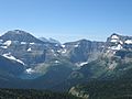
View from top of Summit Trail
-
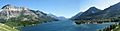
Panorama taken from Prince of Wales hotel looking south
-
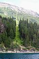
49th parallel at Waterton Lake
-
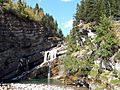
Cameron Falls
-
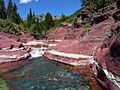
Red Rock Canyon
-
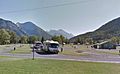
Waterton Park townsite campground
-
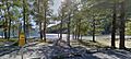
South Beach of Waterton Park townsite
-
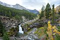
Blakiston Falls (upper)
-
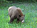
Cinnamon-coloured Black Bear eating dandelions, in Akamina Parkway.
-
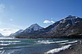
View of the mountains surrounding the Waterton Lake.
-
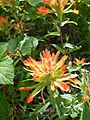
Castilleja miniata Indian Paintbrush on the Bears Hump
-
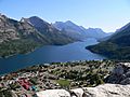
View from Bears Hump
-
View of Vimy Peak


.jpg)
.jpg)
See also
 In Spanish: Parque nacional Waterton Lakes para niños
