Waterton Park facts for kids
Quick facts for kids
Waterton Park
|
|
|---|---|

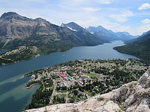
View from above of Waterton Park
|
|
| Country | Canada |
| Province | Alberta |
| Census division | No. 3 |
| Improvement District | Improvement District No. 4 Waterton |
| Government | |
| • Type | Unincorporated |
| Area
(2021)
|
|
| • Land | 482.54 km2 (186.31 sq mi) |
| Elevation | 1,280 m (4,200 ft) |
| Population
(2021)
|
|
| • Total | 132 |
| Time zone | UTC−7 (MST) |
| • Summer (DST) | UTC−6 (MDT) |
| Area code(s) | 403 / 587 |
| highways | |
Waterton Park, often called Waterton, is a small community in southwestern Alberta, Canada. It's located inside Waterton Lakes National Park, which is a special protected area.
This hamlet is found at the end of Highway 5. It's about 54 kilometers (34 miles) west of Cardston and 55 kilometers (34 miles) south of Pincher Creek. Waterton is also just north of Glacier National Park in Montana, USA. The community sits at an elevation of 1,280 meters (4,199 feet) above sea level.
Waterton Park is part of a larger area known as Census Division No. 3. It is also within the federal voting district called Lethbridge.
People Living in Waterton Park
|
|||||||||||||||||||||||||||||||||||||||||||||||||||
In 2021, the Canadian government counted the population of Waterton Park. There were 132 people living there. They lived in 54 homes out of 195 available houses. This was an increase of about 25% from 2016, when 105 people lived there.
The land area of Waterton Park is about 482.54 square kilometers (186.31 square miles). This means there were about 0.3 people living per square kilometer in 2021.
Weather in Waterton Park
Waterton Park has a type of weather called a humid continental climate. This means it has four distinct seasons. Summers are usually mild, with cool nights. Winters are cold, but temperatures often stay around freezing.
It rains or snows fairly consistently throughout the year. However, the most rain usually falls in May and June.
| Climate data for Waterton Park | |||||||||||||
|---|---|---|---|---|---|---|---|---|---|---|---|---|---|
| Month | Jan | Feb | Mar | Apr | May | Jun | Jul | Aug | Sep | Oct | Nov | Dec | Year |
| Record high °C (°F) | 15 (59) |
17 (63) |
20 (68) |
26.5 (79.7) |
30 (86) |
31 (88) |
34.5 (94.1) |
34 (93) |
32.8 (91.0) |
29 (84) |
19 (66) |
20 (68) |
34.5 (94.1) |
| Mean daily maximum °C (°F) | 0.3 (32.5) |
1.3 (34.3) |
5.3 (41.5) |
10 (50) |
15 (59) |
19 (66) |
22.5 (72.5) |
22 (72) |
17.3 (63.1) |
11.8 (53.2) |
3.1 (37.6) |
−0.3 (31.5) |
10.6 (51.1) |
| Mean daily minimum °C (°F) | −10.6 (12.9) |
−9.8 (14.4) |
−5.5 (22.1) |
−1.5 (29.3) |
2.8 (37.0) |
6.1 (43.0) |
7.9 (46.2) |
6.9 (44.4) |
3.4 (38.1) |
0.6 (33.1) |
−5.8 (21.6) |
−9.7 (14.5) |
−1.3 (29.7) |
| Record low °C (°F) | −40.5 (−40.9) |
−50 (−58) |
−34.4 (−29.9) |
−24.4 (−11.9) |
−11 (12) |
−6 (21) |
−3 (27) |
−5 (23) |
−12 (10) |
−27 (−17) |
−34 (−29) |
−44.5 (−48.1) |
−50 (−58) |
| Average precipitation mm (inches) | 59.3 (2.33) |
46.3 (1.82) |
69.3 (2.73) |
64.5 (2.54) |
94.5 (3.72) |
80.8 (3.18) |
70.8 (2.79) |
69 (2.7) |
60.8 (2.39) |
65.1 (2.56) |
68.7 (2.70) |
58.4 (2.30) |
807.6 (31.80) |
| Source: Environment Canada | |||||||||||||
More About Communities
If you want to learn more about places like Waterton Park, check out these lists:
- List of communities in Alberta
- List of designated places in Alberta
- List of hamlets in Alberta
 | Bessie Coleman |
 | Spann Watson |
 | Jill E. Brown |
 | Sherman W. White |


