Glacier County, Montana facts for kids
Quick facts for kids
Glacier County
|
|
|---|---|

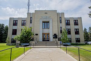
Glacier County Courthouse in Cut Bank
|
|

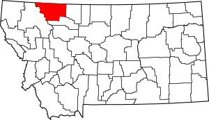
Location within the U.S. state of Montana
|
|
 Montana's location within the U.S. |
|
| Country | |
| State | |
| Founded | 1919 |
| Named for | The glaciers in Glacier National Park |
| Seat | Cut Bank |
| Largest city | Cut Bank |
| Area | |
| • Total | 3,037 sq mi (7,870 km2) |
| • Land | 2,996 sq mi (7,760 km2) |
| • Water | 41 sq mi (110 km2) 1.40% |
| Population
(2020)
|
|
| • Total | 13,778 |
| • Estimate
(2022)
|
13,681 |
| • Density | 4.5367/sq mi (1.7516/km2) |
| Time zone | UTC−7 (Mountain) |
| • Summer (DST) | UTC−6 (MDT) |
| Congressional district | 1st |
|
|
Glacier County is a special place in the state of Montana, USA. In 2020, about 13,778 people lived here. It's located in northwestern Montana, right where the wide-open Great Plains meet the tall Rocky Mountains. The Blackfeet people call the Rocky Mountains the "Backbone of the World."
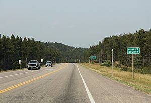
This county is full of different landscapes and cultures. It includes the Blackfeet Indian Reservation, parts of Glacier National Park, and parts of Lewis and Clark National Forest. Glacier County also shares a 75-mile border with Alberta, Canada. There are two border crossings open all year and one that opens seasonally.
Towns and Communities
Glacier County has several small communities. Some are unincorporated, meaning they don't have their own local government. Others are incorporated towns or cities with their own local rules.
Cut Bank: The County Seat
Cut Bank is the main town in Glacier County, called the county seat. About 3,000 people live here. It's located in the eastern part of the county, on the edge of the Great Plains.
Cut Bank grew because of the railway and farming needs of the area. It also became bigger during an oil boom in the 1920s. The town has a mix of different people because of its history. You can find a hospital, a clinic, and an airport here. There's also a nine-hole golf course and a swimming pool. You can visit nearby historical sites from the Lewis and Clark Expedition. The Glacier County Museum has old tools, historic buildings, and information about the early history of the area, including a lot about Blackfeet history.
Browning: Home of the Blackfeet Tribe
Browning is the main town and government center for the Blackfeet Tribe. About 1,400 people live in the official town area. However, the wider community has about 7,000 people. Most of these are members of the Blackfeet Tribe. Their history in this area goes back over 400 years.
Browning has many businesses and resources. These include a federal building, a community college, and a Native American Museum and Heritage Center. There's also a casino, fairgrounds, a racetrack, and a special camp area. This camp area hosts an annual Native American celebration and powwow. Many events happen here in the summer. You can also find permits for Blackfeet tribal fishing, hunting, and other outdoor activities.
Babb: Gateway to Glacier National Park
Babb is a small farming and ranching community. It is located on the Blackfeet Indian Reservation. Many tourists visit Babb in the summer. This is because it's the main way to get to the Many Glacier area of Glacier National Park.
Babb has a school, a post office, a fire station, and a general store. You can also find a motel, a gas station, several restaurants, and two churches. Nearby attractions include Glacier National Park and the historic Many Glacier Hotel. You can also see the St. Mary River and Chief Mountain. Two border crossings into Canada, Piegan and Chief Mountain, are also close by.
East Glacier Park Village: A Summer Hub
East Glacier Park Village is a small community in winter. But it gets very busy in the summertime. Many visitors come, and people from all over the world work here to help the larger summer population. This village is home to the biggest of Glacier Park's historic hotels. It also has a fleet of famous "red buses." You can enjoy a nine-hole golf course, campgrounds, trail rides, and boat rides here. There are also tours that teach about Native American culture.
St. Mary: On the Park's Edge
St. Mary is a community right next to Glacier National Park. It's on the western edge of the Blackfeet Native American Reservation. This village is where the Going-to-the-Sun Road begins on the east side. This famous road goes through the park for about 53 miles.
Fewer than 50 people live in St. Mary all year. But on a busy summer evening, the population can grow ten times larger! The village has several places to stay, restaurants, and cafes. There's also a small grocery store, two gas stations, and campgrounds. A large area for National Park Service workers is located near the village, inside the park. U.S. Route 89 goes through St. Mary. The village is located between Saint Mary Lake in Glacier National Park and Lower St. Mary Lake on the Blackfeet Native American Reservation.
Geography
Glacier County covers a total area of about 3,037 square miles. About 2,996 square miles of this is land, and 41 square miles (about 1.3%) is water. A large part of the county, about 71% of its land, is within the Blackfeet Indian Reservation. Another 21% of the county is inside Glacier National Park.
Neighboring Areas
- Flathead County - west
- Pondera County - south
- Toole County - east
- Cardston County, Alberta - north
- Improvement District No. 4, Alberta (Waterton Lakes National Park) - northwest
- County of Warner No. 5, Alberta - northeast
Protected Natural Areas
- Glacier National Park (part)
- Lewis and Clark National Forest (part)
Population Information
| Historical population | |||
|---|---|---|---|
| Census | Pop. | %± | |
| 1920 | 4,178 | — | |
| 1930 | 5,297 | 26.8% | |
| 1940 | 9,034 | 70.5% | |
| 1950 | 9,645 | 6.8% | |
| 1960 | 11,565 | 19.9% | |
| 1970 | 10,783 | −6.8% | |
| 1980 | 10,628 | −1.4% | |
| 1990 | 12,121 | 14.0% | |
| 2000 | 13,247 | 9.3% | |
| 2010 | 13,447 | 1.5% | |
| 2020 | 13,778 | 2.5% | |
| 2022 (est.) | 13,681 | 1.7% | |
| U.S. Decennial Census 1790–1960, 1900–1990, 1990–2000, 2010–2020 |
|||
2020 Census Details
In 2020, the census showed that 13,778 people lived in Glacier County.
2010 Census Details
According to the 2010 census, there were 13,399 people living in the county. Most people identified as Native American or white. A small number of people were from other racial backgrounds. About 1.8% of the population was of Hispanic or Latino origin.
Many households had children under 18 living with them. The average household had about 2.91 people.
Communities List

City
- Cut Bank (county seat)
Census-Designated Places (CDPs)
- Babb
- Big Sky Colony
- Blackfoot
- East Glacier Park Village
- Glacier Colony
- Glendale Colony
- Hidden Lake Colony
- Horizon Colony
- Little Browning
- North Browning
- Santa Rita
- Seville Colony
- South Browning
- St. Mary
- Starr School
- Zenith Colony
Unincorporated Communities
- Bison
- False Summit
- Fort Piegan
- Gunsight
- Kiowa
- Meriwether
- Piegan
- Rising Sun
- Star
- Summit
- Sundance
- Swift Current
- Browning
Education
Glacier County has several school districts for both high school and elementary school students.
High School Districts
- Browning High School District
- Cut Bank High School District
Elementary School Districts
- Browning Elementary School District
- Cut Bank Elementary School District
- East Glacier Park Elementary School District
- Mountain View Elementary School District
See also
 In Spanish: Condado de Glacier para niños
 | Aurelia Browder |
 | Nannie Helen Burroughs |
 | Michelle Alexander |

