Browning, Montana facts for kids
Quick facts for kids
Browning, Montana
|
|
|---|---|
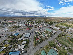
Downtown Browning in September 2022. Photo by Lukas Eddy
|
|
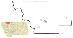
Location of Browning, Montana
|
|
| Country | United States |
| State | Montana |
| County | Glacier |
| Area | |
| • Total | 0.28 sq mi (0.72 km2) |
| • Land | 0.28 sq mi (0.72 km2) |
| • Water | 0.00 sq mi (0.00 km2) |
| Elevation | 4,377 ft (1,334 m) |
| Population
(2020)
|
|
| • Total | 1,018 |
| • Density | 3,688.41/sq mi (1,422.32/km2) |
| Time zone | UTC-7 (Mountain (MST)) |
| • Summer (DST) | UTC-6 (MDT) |
| ZIP code |
59417
|
| Area code(s) | 406 |
| FIPS code | 30-10375 |
| GNIS feature ID | 2831321 |
Browning is a special kind of community in Glacier County, Montana, United States. It's called a Census-designated place, which means it's a community that the government counts for population, but it doesn't have its own city government.
Browning is very important because it's the main center for the Blackfeet Indian Reservation. It used to be the only official town on the Reservation. In 2020, about 1,018 people lived there.
The community got its name in 1885 from Daniel M. Browning, who was in charge of Indian Affairs at the time. The local post office opened in 1895. Browning stopped being an official town on September 26, 2018, because its local government had money problems.
Contents
Geography and Climate
Browning is a small area, covering about 0.27 square miles (0.72 square kilometers) of land.
Browning's Weather
Browning has a unique climate. It's often cold and can be quite dry. It's known for a world record temperature drop! From January 23 to January 24, 1916, the temperature fell an amazing 100°F (56°C). It went from 44°F (7°C) to a freezing -56°F (-49°C) in just one day.
Temperatures can change a lot, especially in fall, winter, and spring. Cold air from Canada can cause sudden drops. But warm winds called "chinooks" can make temperatures rise quickly.
It rains or snows about 14 inches (35 cm) each year. Most of the snow falls from November to April. June is usually the wettest month, with many showers and thunderstorms.
| Climate data for Browning (1894-1989) | |||||||||||||
|---|---|---|---|---|---|---|---|---|---|---|---|---|---|
| Month | Jan | Feb | Mar | Apr | May | Jun | Jul | Aug | Sep | Oct | Nov | Dec | Year |
| Record high °F (°C) | 66 (19) |
68 (20) |
72 (22) |
91 (33) |
93 (34) |
100 (38) |
99 (37) |
102 (39) |
94 (34) |
83 (28) |
72 (22) |
69 (21) |
102 (39) |
| Mean daily maximum °F (°C) | 28.2 (−2.1) |
31.9 (−0.1) |
38.0 (3.3) |
50.5 (10.3) |
60.7 (15.9) |
68.1 (20.1) |
77.8 (25.4) |
76.0 (24.4) |
65.4 (18.6) |
55.2 (12.9) |
40.2 (4.6) |
32.2 (0.1) |
52.0 (11.1) |
| Mean daily minimum °F (°C) | 8.0 (−13.3) |
11.2 (−11.6) |
16.9 (−8.4) |
27.3 (−2.6) |
35.5 (1.9) |
41.8 (5.4) |
46.1 (7.8) |
44.4 (6.9) |
37.5 (3.1) |
30.9 (−0.6) |
19.9 (−6.7) |
13.3 (−10.4) |
27.7 (−2.4) |
| Record low °F (°C) | −56 (−49) |
−46 (−43) |
−38 (−39) |
−14 (−26) |
1 (−17) |
21 (−6) |
24 (−4) |
19 (−7) |
0 (−18) |
−17 (−27) |
−39 (−39) |
−47 (−44) |
−56 (−49) |
| Average precipitation inches (mm) | 0.81 (21) |
0.70 (18) |
0.81 (21) |
1.09 (28) |
2.00 (51) |
2.77 (70) |
1.51 (38) |
1.39 (35) |
1.53 (39) |
0.83 (21) |
0.81 (21) |
0.72 (18) |
14.97 (381) |
| Average snowfall inches (cm) | 9.5 (24) |
8.3 (21) |
8.9 (23) |
6.6 (17) |
2.3 (5.8) |
0.4 (1.0) |
0.1 (0.25) |
0.1 (0.25) |
2.6 (6.6) |
4.2 (11) |
7.4 (19) |
9.1 (23) |
59.5 (151.9) |
People of Browning
| Historical population | |||
|---|---|---|---|
| Census | Pop. | %± | |
| 1920 | 986 | — | |
| 1930 | 1,172 | 18.9% | |
| 1940 | 1,825 | 55.7% | |
| 1950 | 1,691 | −7.3% | |
| 1960 | 2,011 | 18.9% | |
| 1970 | 1,700 | −15.5% | |
| 1980 | 1,226 | −27.9% | |
| 1990 | 1,170 | −4.6% | |
| 2000 | 1,065 | −9.0% | |
| 2010 | 1,016 | −4.6% | |
| 2020 | 1,018 | 0.2% | |
| U.S. Decennial Census | |||
2010 Census Information
In 2010, there were 1,016 people living in Browning. Most of the people (92.7%) were Native American. About 5.5% were White.
Many households (45.3%) had children under 18 living there. The average age of people in Browning was about 29.8 years old.
Education in Browning
Browning has its own public school system, called Browning Public Schools. This system includes both elementary and high schools. Students from kindergarten all the way through 12th grade attend these schools. The high school team is known as the "Indians."
Browning is also home to Blackfeet Community College. This college offers higher education opportunities.
Besides the public schools, there are other learning options:
- A language program called Cutswood Academy focuses on language immersion.
- The De La Salle Blackfeet School is a small Catholic school run by the De La Salle Christian Brothers.
Media and News
Browning has its own local radio station, KBWG-LP, which broadcasts at 107.5 FM.
For news, people in Browning and Glacier County can read The Glacier Reporter. This newspaper is available both in print and online.
Getting Around Browning
Transportation Routes
Browning is a hub for important roads:
- US Route 2 comes into Browning from the west, near East Glacier.
- US Route 89 arrives from the north, from St. Mary.
- These two major roads join up on the west side of Browning and travel together through the community. They then split again on the east side. US 2 heads east towards Cut Bank and Shelby. US 89 goes south towards Choteau and Great Falls.
- Another road, US Route 87, used to go through Browning until 1934.
Train Travel
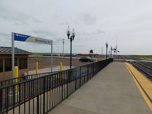
You can also reach Browning by train! The Empire Builder train, run by Amtrak, stops in Browning from October to April. This train travels between Chicago and Portland/Seattle. During the warmer months (April to October), passengers use the East Glacier station, which is just a few miles west.
Famous People from Browning
Many talented people have connections to Browning, Montana. Here are a few:
- Shannon Augare – a politician
- William Big Springs – an artist
- Michele Binkley – a politician
- Frosty Boss Ribs – a politician
- Jackie Larson Bread – known for her beadwork art
- Gladys Cardiff – a Native American poet and professor
- Elouise Pepion Cobell – a winner of the MacArthur Grant and a key person in a famous legal case
- Lila Walter Evans – a politician
- Lily Gladstone – an actress
- Bonnie HeavyRunner – a professor
- Joe Hipp – a professional boxer
- Carol Juneau – a politician and teacher
- Denise Juneau – a politician
- Darrell Kipp – a teacher, filmmaker, and historian
- Terran Last Gun – an artist
- Stuart Long – a Roman Catholic priest who served in Browning
- Zahn McClarnon – an actor
- Earl Old Person – an honorary lifetime chief of the Blackfeet Nation
- Albert Racine – an artist
- Steve Reevis – an actor
- Hart Merriam Schultz – an artist
- Robert Scriver – a sculptor and museum owner
- Marvin Weatherwax Jr. – a politician
- James Welch – a poet and author
- Tyson Running Wolf – a member of the Montana House of Representatives
- Alfred Young Man – an artist, writer, and teacher
See also
 In Spanish: Browning (Montana) para niños
 | Percy Lavon Julian |
 | Katherine Johnson |
 | George Washington Carver |
 | Annie Easley |


