North Browning, Montana facts for kids
Quick facts for kids
North Browning, Montana
|
|
|---|---|

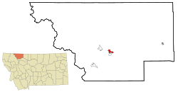
Location of North Browning, Montana
|
|
| Country | United States |
| State | Montana |
| County | Glacier |
| Area | |
| • Total | 2.90 sq mi (7.51 km2) |
| • Land | 2.89 sq mi (7.49 km2) |
| • Water | 0.01 sq mi (0.02 km2) |
| Elevation | 4,367 ft (1,331 m) |
| Population
(2020)
|
|
| • Total | 2,653 |
| • Density | 917.68/sq mi (354.32/km2) |
| Time zone | UTC-7 (Mountain (MST)) |
| • Summer (DST) | UTC-6 (MDT) |
| Area code(s) | 406 |
| FIPS code | 30-54510 |
| GNIS feature ID | 1867341 |
North Browning is a special kind of community in Glacier County, Montana, United States. It's called a census-designated place (CDP). This means it's an area that looks like a town but isn't officially set up as one with its own local government. In 2010, about 2,408 people lived there. By 2020, the population grew to 2,653.
Contents
Where is North Browning Located?
North Browning is found at coordinates 48.567499 degrees north and -113.017871 degrees west. It sits right next to the town of Browning to its south. This area is also part of the Blackfeet Indian Reservation.
Land and Water Area
According to the United States Census Bureau, North Browning covers a total area of about 9.9 square kilometers (or 3.8 square miles). Most of this area is land. Only a very small part, about 0.02 square kilometers (0.01 square miles), is water.
Who Lives in North Browning?
| Historical population | |||
|---|---|---|---|
| Census | Pop. | %± | |
| 2020 | 2,653 | — | |
| U.S. Decennial Census | |||
In the year 2000, there were 2,200 people living in North Browning. These people lived in 600 different homes, and 495 of these were families.
Population Makeup
Most people in North Browning are Native American, making up about 93.73% of the population in 2000. A smaller number of people were White (4.64%), and very few were African American, Asian, or Pacific Islander. About 1.41% of the population identified as being from two or more races. Also, about 1.23% of the people were Hispanic or Latino.
Age Groups
The population in North Browning is quite young. In 2000, about 38.7% of the people were under 18 years old. About 11.2% were between 18 and 24 years old. The median age was 25 years, which means half the people were younger than 25 and half were older.
Household Income
In 2000, the average income for a household in North Browning was about $24,399 per year. For families, the average income was around $26,071. It's important to know that about 35.7% of all people, and 41.4% of those under 18, lived below the poverty line at that time.
Schools in North Browning
The schools in this area are part of the Browning Public Schools district. This district includes both the Browning Elementary School District and the Browning High School District, serving students from kindergarten all the way through high school.
See also
 In Spanish: North Browning (Montana) para niños
 | James B. Knighten |
 | Azellia White |
 | Willa Brown |

